Sunset Lake Floating Bridge

Log in to your account

AroundUs is a community-driven map of interesting places, built by curious explorers like you. It grows with every review, story, and photo you share.
Connect to save your favorite spots, contribute locations, and create personalized routes.
Continue with Google
Continue with Apple
Continue with X
Continue with Facebook
Continue with email
By continuing, you accept our Terms and Conditions and our Privacy Policy
Create an account
Add to collection
Map
Suggest a change
Share

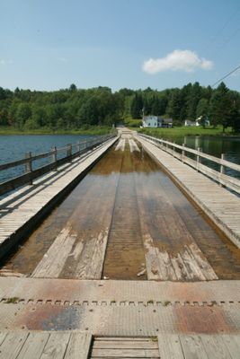
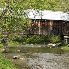
Sunset Lake Floating Bridge, Floating road bridge in Brookfield, Vermont, US.

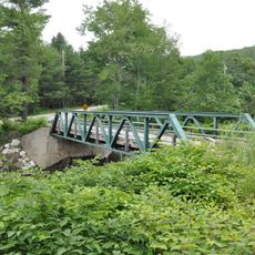
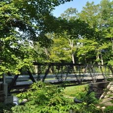
Sunset Lake Floating Bridge is a pontoon-based road crossing that carries Vermont Route 65 across the water and spans approximately 318 feet. It accommodates regular vehicle traffic with pedestrian walkways on each side, all supported by fiber-reinforced polymer floats that provide structural stability.

The first structure was built in 1820 when residents realized that standard pilings would not work because of the lake's depth. Over roughly two centuries, eight different versions were constructed as builders adapted to changing needs and engineering advances.

The bridge serves as a gathering point where locals and visitors fish from the railings and enjoy the water below throughout the seasons. Its role as a social hub reflects how the community has integrated this engineering solution into daily life and recreation.

The bridge accommodates both vehicle and pedestrian traffic with dedicated walkways on each side for safer passage. Visitors should be prepared for varied weather, as the floating structure can experience windier conditions than the surrounding landscape.

This is the only floating bridge east of the Mississippi River in the United States and represents an unusual engineering solution for this region. The fact that eight different versions were built at this location shows how engineers continuously tried and refined new approaches over time.

Location: Brookfield

Official opening: 1820

GPS coordinates: 44.04250,-72.60470

Latest update: December 11, 2025 11:08

Photos
Hidden places in Vermont: granite quarries, covered bridges, historic villages

Vermont hides historic places away from main roads, often forgotten by hurried travelers. Here you find granite quarries still working or long abandoned, small rural schools from the 1800s where children learned together, wooden covered bridges, and waterfalls flowing through thick forests. Trails...

Around this place
Barre Granite
United States of America

Barre Granite

15.6 km
Allis State Park
United States of America

Allis State Park

2.5 km
Northfield Falls Covered Bridge
United States of America

Northfield Falls Covered Bridge

14.9 km
Slaughter House Covered Bridge
United States of America

Slaughter House Covered Bridge

14.6 km
Randolph Center Historic District
United States of America

Randolph Center Historic District

11.6 km
Braley Covered Bridge
United States of America

Braley Covered Bridge

13.3 km
Flint Covered Bridge
United States of America

Flint Covered Bridge

15.7 km
Gifford Covered Bridge
United States of America

Gifford Covered Bridge

14.6 km
Stony Brook Covered Bridge
United States of America

Stony Brook Covered Bridge

11 km
Lower Cox Brook Covered Bridge
United States of America

Lower Cox Brook Covered Bridge

15 km
Lover's Lane Bridge
United States of America

Lover's Lane Bridge

16.6 km
Kingsbury Covered Bridge
United States of America

Kingsbury Covered Bridge

18.1 km
Moxley Covered Bridge
United States of America

Moxley Covered Bridge

14.8 km
Chandler Music Hall
United States of America

Chandler Music Hall

13.9 km
Mari-Castle
United States of America

Mari-Castle

14.8 km
Upper Cox Brook Covered Bridge
United States of America

Upper Cox Brook Covered Bridge

15.1 km
Marvin Newton House
United States of America

Marvin Newton House

2.1 km
Kimball Public Library
United States of America

Kimball Public Library

13.9 km
Foundry Bridge
United States of America

Foundry Bridge

17.5 km
Larkin Covered Bridge
United States of America

Larkin Covered Bridge

17.4 km
Nichols House
United States of America

Nichols House

16.7 km
Brookfield Village Historic District
United States of America

Brookfield Village Historic District

229 m
Brown Public Library
United States of America

Brown Public Library

12.4 km
Mayo Building
United States of America

Mayo Building

12.5 km
Chelsea Village Historic District
United States of America

Chelsea Village Historic District

13.9 km
Depot Square Historic District
United States of America

Depot Square Historic District

14.1 km
Old Red Mill
United States of America

Old Red Mill

9.5 km
Rock of Ages Granite Quarry
United States of America

Rock of Ages Granite Quarry

18.6 km
Show the full map
Reviews

Visited this place? Tap the stars to rate it and share your experience / photos with the community! Try now! You can cancel it anytime.

« Sunset Lake Floating Bridge - Floating road bridge in Brookfield, Vermont, US » is provided by Around Us (aroundus.com). Images and texts are derived from Wikimedia project under a Creative Commons license. You are allowed to copy, distribute, and modify copies of this page, under the conditions set by the license, as long as this note is clearly visible.

Discover hidden gems everywhere you go!

From secret cafés to breathtaking viewpoints, skip the crowded tourist spots and find places that match your style. Our app makes it easy with voice search, smart filtering, route optimization, and insider tips from travelers worldwide. Download now for the complete mobile experience.

Around Us App Screenshot

A unique approach to discovering new places

Le Figaro

All the places worth exploring

France Info

A tailor-made excursion in just a few clicks

20 Minutes