Log in to your account

AroundUs is a community-driven map of interesting places, built by curious explorers like you. It grows with every review, story, and photo you share.
Connect to save your favorite spots, contribute locations, and create personalized routes.
Continue with Google
Continue with Apple
Continue with X
Continue with Facebook
Continue with email
By continuing, you accept our Terms and Conditions and our Privacy Policy
Create an account

Wapanocca National Wildlife Refuge

Add to collection
Map
Suggest a change
Share

Wapanocca National Wildlife Refuge, National Wildlife Refuge in Crittenden County, Arkansas.

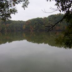
Wapanocca National Wildlife Refuge is a protected area of wetlands, forests, and grasslands located about four miles west of the Mississippi River near Turrell. The property covers more than 5,400 acres and includes a large system of lakes and ponds essential for waterfowl.

The land was acquired in 1961 from the Wapanocca Outing Club, a hunting organization founded in 1886. The conversion of the hunting grounds into a wildlife refuge marked a shift in how this valuable land was managed.

The refuge serves as a place where visitors connect with nature through watching birds and exploring wild habitats. The setting encourages people to understand how wetlands support life and communities depend on these natural areas.

Visitors can explore the grounds via marked trails and observation platforms to watch birds in their natural setting. The best times to visit are fall and spring when migratory birds are passing through or resting.

The large lake in the refuge originated from an ancient bend of the Mississippi River and provides special habitats for migratory birds. This natural formation is uncommonly found and makes the area ecologically valuable in a distinctive way.

Location: Crittenden County

Inception: 1961

Website: https://fws.gov/refuge/wapanocca

GPS coordinates: 35.34580,-90.21670

Latest update: December 11, 2025 18:10

Photos
Around this place
Hernando de Soto Bridge
United States of America

Hernando de Soto Bridge

25.6 km
Memphis Suspension Railway
United States of America

Memphis Suspension Railway

26.2 km
Memphis International Raceway
United States of America

Memphis International Raceway

25.4 km
100 North Main
United States of America

100 North Main

26.7 km
Burkle Estate
United States of America

Burkle Estate

25.6 km
Meeman-Shelby Forest State Park
United States of America

Meeman-Shelby Forest State Park

14.2 km
Morgan Keegan Tower
United States of America

Morgan Keegan Tower

26.7 km
Fire Museum of Memphis
United States of America

Fire Museum of Memphis

26.7 km
Earle High School
United States of America

Earle High School

24.6 km
Adams Avenue Historic District
United States of America

Adams Avenue Historic District

26.7 km
The Renaissance Apartments
United States of America

The Renaissance Apartments

26.6 km
Crittenden County Courthouse
United States of America

Crittenden County Courthouse

14.6 km
Slave Haven Underground Railroad Museum
United States of America

Slave Haven Underground Railroad Museum

25.6 km
Berry Cemetery
United States of America

Berry Cemetery

23.4 km
Hamilton Apartments
United States of America

Hamilton Apartments

22 km
Tyronza Water Tower
United States of America

Tyronza Water Tower

20.5 km
Lawrie House
United States of America

Lawrie House

21.8 km
West Memphis City Hall
United States of America

West Memphis City Hall

22.5 km
Marion Colored High School
United States of America

Marion Colored High School

13.9 km
Porter-Leath House
United States of America

Porter-Leath House

26.2 km
Crittenden County Bank and Trust Company
United States of America

Crittenden County Bank and Trust Company

14.8 km
Johnson-Portis House
United States of America

Johnson-Portis House

21.8 km
Greenlaw Addition Historic District
United States of America

Greenlaw Addition Historic District

26.1 km
Tyronza Methodist Episcopal Church, South
United States of America

Tyronza Methodist Episcopal Church, South

20.6 km
Wilson Power and Light Company Ice Plant
United States of America

Wilson Power and Light Company Ice Plant

22.4 km
Old Turrell City Hall
United States of America

Old Turrell City Hall

5.1 km
George Collins Love House
United States of America

George Collins Love House

26.3 km
A Tour of Possibilities
United States of America

A Tour of Possibilities

26.4 km
Show the full map
Reviews

Visited this place? Tap the stars to rate it and share your experience / photos with the community! Try now! You can cancel it anytime.

« Wapanocca National Wildlife Refuge - National Wildlife Refuge in Crittenden County, Arkansas » is provided by Around Us (aroundus.com). Images and texts are derived from Wikimedia project under a Creative Commons license. You are allowed to copy, distribute, and modify copies of this page, under the conditions set by the license, as long as this note is clearly visible.

Discover hidden gems everywhere you go!

From secret cafés to breathtaking viewpoints, skip the crowded tourist spots and find places that match your style. Our app makes it easy with voice search, smart filtering, route optimization, and insider tips from travelers worldwide. Download now for the complete mobile experience.

Around Us App Screenshot

A unique approach to discovering new places

Le Figaro

All the places worth exploring

France Info

A tailor-made excursion in just a few clicks

20 Minutes