Zook's Mill Covered Bridge

Log in to your account

AroundUs is a community-driven map of interesting places, built by curious explorers like you. It grows with every review, story, and photo you share.
Connect to save your favorite spots, contribute locations, and create personalized routes.
Continue with Google
Continue with Apple
Continue with X
Continue with Facebook
Continue with email
By continuing, you accept our Terms and Conditions and our Privacy Policy
Create an account
Add to collection
Map
Suggest a change
Share

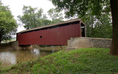
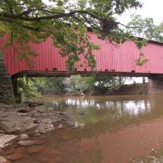
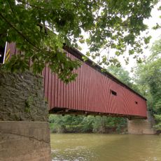
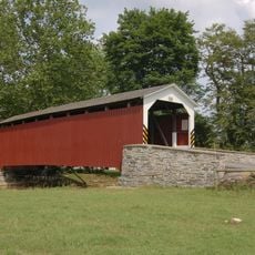
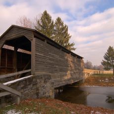
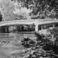
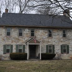
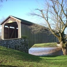
Zook's Mill Covered Bridge, Covered bridge in Lancaster County, Pennsylvania.

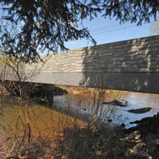
Zook's Mill Covered Bridge is a wooden covered bridge over Cocalico Creek built with a double arch truss design and painted red with white trim details. The structure measures about 74 feet across and has an overhead clearance of approximately 11 feet 6 inches for passing vehicles.

Miller Henry Zook built the bridge in 1849 to connect his mill property across Cocalico Creek. The structure gained recognition by the National Register of Historic Places in 1980 for its historical importance and preserved engineering methods.

The bridge carries the name of Miller Henry Zook who built it and displays the construction skills that early settlers in Pennsylvania developed and passed on. Visitors can see the wooden beams and metal reinforcements visible throughout the structure, showing how builders created lasting bridges without modern equipment.

The bridge is located west of Brownstown on Route T 797 connecting Warwick and West Earl Townships. Visitors should proceed slowly whether driving or walking, as the passage is narrow and visibility around the corners can be limited.

During Hurricane Agnes in 1972, the bridge displayed remarkable resistance when water levels surged to extreme heights during the storm. Despite this severe test, it sustained only minimal damage and proved that its solid 19th-century construction could withstand modern natural disasters.

Location: Warwick Township

Location: West Earl Township

GPS coordinates: 40.13020,-76.23180

Latest update: December 14, 2025 14:20

Photos
Around this place
Ephrata Cloister
United States of America

Ephrata Cloister

6.9 km
The Hess Homestead
United States of America

The Hess Homestead

5.3 km
Landis Valley Museum
United States of America

Landis Valley Museum

5.8 km
Bitzer's Mill Covered Bridge
United States of America

Bitzer's Mill Covered Bridge

6.9 km
Lititz Moravian Historic District
United States of America

Lititz Moravian Historic District

6.5 km
Keller's Mill Covered Bridge
United States of America

Keller's Mill Covered Bridge

3.8 km
Pinetown Bushong's Mill Covered Bridge
United States of America

Pinetown Bushong's Mill Covered Bridge

3.1 km
Erb's Covered Bridge
United States of America

Erb's Covered Bridge

4.3 km
Johann Agust Sutter House
United States of America

Johann Agust Sutter House

7 km
Buck Hill Farm Covered Bridge
United States of America

Buck Hill Farm Covered Bridge

5.9 km
Conestoga Creek Viaduct
United States of America

Conestoga Creek Viaduct

9.8 km
Shreiner Farm
United States of America

Shreiner Farm

2.4 km
Ephrata Commercial Historic District
United States of America

Ephrata Commercial Historic District

7.1 km
Connell Mansion
United States of America

Connell Mansion

7.1 km
Bridge in West Earl Township
United States of America

Bridge in West Earl Township

2.7 km
William Werner House
United States of America

William Werner House

6.9 km
Jacob Keller Farm
United States of America

Jacob Keller Farm

5 km
Windom Mill Farm
United States of America

Windom Mill Farm

2.4 km
Hibshman Farm
United States of America

Hibshman Farm

9.6 km
Eby Shoe Corporation buildings
United States of America

Eby Shoe Corporation buildings

7.4 km
Brunnerville Road Bridge over Hammer Creek
United States of America

Brunnerville Road Bridge over Hammer Creek

8.4 km
Christian Stauffer House
United States of America

Christian Stauffer House

8.1 km
Christian and Emma Herr Farm
United States of America

Christian and Emma Herr Farm

2.4 km
Peter and Catherine Reyer Farmhouse
United States of America

Peter and Catherine Reyer Farmhouse

8.4 km
Lititz Historical Foundation
United States of America

Lititz Historical Foundation

6.7 km
Hunsecker's Mill Covered Bridge
United States of America

Hunsecker's Mill Covered Bridge

5 km
Oregon Mill Complex
United States of America

Oregon Mill Complex

2.4 km
Mentzer Building
United States of America

Mentzer Building

7.1 km
Show the full map
Reviews

Visited this place? Tap the stars to rate it and share your experience / photos with the community! Try now! You can cancel it anytime.

« Zook's Mill Covered Bridge - Covered bridge in Lancaster County, Pennsylvania » is provided by Around Us (aroundus.com). Images and texts are derived from Wikimedia project under a Creative Commons license. You are allowed to copy, distribute, and modify copies of this page, under the conditions set by the license, as long as this note is clearly visible.

Discover hidden gems everywhere you go!

From secret cafés to breathtaking viewpoints, skip the crowded tourist spots and find places that match your style. Our app makes it easy with voice search, smart filtering, route optimization, and insider tips from travelers worldwide. Download now for the complete mobile experience.

Around Us App Screenshot

A unique approach to discovering new places

Le Figaro

All the places worth exploring

France Info

A tailor-made excursion in just a few clicks

20 Minutes