Enable Location

We need your location to show you interesting places around you

Discover nearby places

Find interesting locations and hidden gems around you

Precise directions

Get accurate directions and distances to places

Your location is never shared with other users. It's only used when you tap the location button.

Erb's Covered Bridge

Log in to your account

Start exploring — it's free

Trusted by 61,562 travelers worldwide

Continue with Google
Continue with Apple
or

We will send you a code to connect

By continuing, you accept our Terms and Conditions and our Privacy Policy

Check your inbox

We've sent a pincode in your inbox. Please enter the code below.

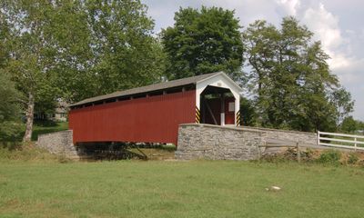
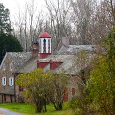
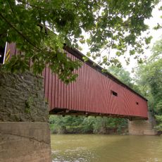
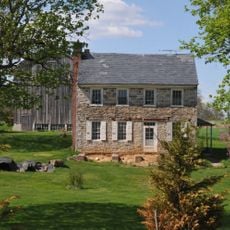
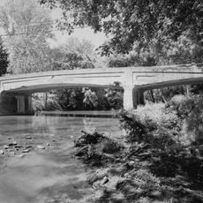
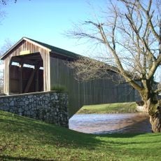
Erb's Covered Bridge, Covered bridge at Rothsville, United States.

Description

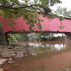
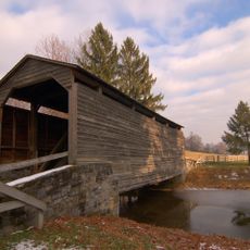
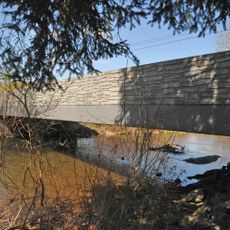
Erb's Covered Bridge crosses Hammer Creek with a wooden arch structure reinforced by steel supports, creating a sturdy crossing. The structure spans about 80 feet and has a deck width of about 13 feet, making it passable for local traffic.

History

The bridge was built in 1849 and later completely rebuilt in 1887, reflecting the evolution of local engineering and growing infrastructure needs. These reconstruction efforts show how the region adapted its crossings to serve changing demands.

Culture

The bridge displays the characteristic red exterior typical of Lancaster County crossings, making it visually distinctive as you approach from either side of Hammer Creek.

Practical

The bridge is accessible via Erb's Bridge Road north of Picnic Woods Road and offers a direct crossing over Hammer Creek on a local route. Visitors should drive carefully since the crossing is narrow and lacks modern safety features.

Did you know?

The structure was added to the National Register of Historic Places in 1980 with registration number 80003536, formally recognizing its status as a landmark. This designation means the bridge is protected and maintained as evidence of local construction history.

Location
Location
GPS coordinates
40.16780,-76.24390
Latest update
December 14, 2025 17:02

AroundUs brings together thousands of curated places, local tips, and hidden gems, enriched daily by 60,000 contributors worldwide. Discover all places nearby (Ephrata Township).

Around this place
Ephrata Cloister
United States of America

Ephrata Cloister

5 km
The Hess Homestead
United States of America

The Hess Homestead

3.9 km
Landis Valley Museum
United States of America

Landis Valley Museum

8.8 km
Clay Township
United States of America

Clay Township

7.8 km
Bitzer's Mill Covered Bridge
United States of America

Bitzer's Mill Covered Bridge

8.4 km
Lititz Moravian Historic District
United States of America

Lititz Moravian Historic District

5.1 km
Keller's Mill Covered Bridge
United States of America

Keller's Mill Covered Bridge

1 km
Stiegel-Coleman House
United States of America

Stiegel-Coleman House

9 km
Zook's Mill Covered Bridge
United States of America

Zook's Mill Covered Bridge

4.3 km
Pinetown Bushong's Mill Covered Bridge
United States of America

Pinetown Bushong's Mill Covered Bridge

7 km
Johann Agust Sutter House
United States of America

Johann Agust Sutter House

5.5 km
Buck Hill Farm Covered Bridge
United States of America

Buck Hill Farm Covered Bridge

6.3 km
Shreiner Farm
United States of America

Shreiner Farm

6.1 km
Ephrata Commercial Historic District
United States of America

Ephrata Commercial Historic District

5.8 km
Connell Mansion
United States of America

Connell Mansion

5.5 km
Bridge in West Earl Township
United States of America

Bridge in West Earl Township

5.8 km
William Werner House
United States of America

William Werner House

5.4 km
Jacob Keller Farm
United States of America

Jacob Keller Farm

3.3 km
Windom Mill Farm
United States of America

Windom Mill Farm

6.1 km
Hibshman Farm
United States of America

Hibshman Farm

7.1 km
Eby Shoe Corporation buildings
United States of America

Eby Shoe Corporation buildings

6.1 km
Brunnerville Road Bridge over Hammer Creek
United States of America

Brunnerville Road Bridge over Hammer Creek

4.4 km
Christian and Emma Herr Farm
United States of America

Christian and Emma Herr Farm

6.1 km
Peter and Catherine Reyer Farmhouse
United States of America

Peter and Catherine Reyer Farmhouse

6.2 km
Lititz Historical Foundation
United States of America

Lititz Historical Foundation

5.2 km
Hunsecker's Mill Covered Bridge
United States of America

Hunsecker's Mill Covered Bridge

9 km
Oregon Mill Complex
United States of America

Oregon Mill Complex

6.1 km
Mentzer Building
United States of America

Mentzer Building

5.7 km
Show the full map
« Erb's Covered Bridge - Covered bridge at Rothsville, United States » is provided by Around Us (aroundus.com). Images and texts are derived from Wikimedia project under a Creative Commons license. You are allowed to copy, distribute, and modify copies of this page, under the conditions set by the license, as long as this note is clearly visible.

Discover hidden gems everywhere you go!

From secret cafés to breathtaking viewpoints, skip the crowded tourist spots and find places that match your style. Our app makes it easy with voice search, smart filtering, route optimization, and insider tips from travelers worldwide. Download now for the complete mobile experience.

Around Us App Screenshot

A unique approach to discovering new places

Le Figaro

All the places worth exploring

France Info

A tailor-made excursion in just a few clicks

20 Minutes

Around Us
Travel Guide & Maps
Download

Send to your phone

QR Code
1

Open the camera app on your mobile.

2

Point at the QR code with your camera. A notification will appear.

3

Tap the notification to open the link.