Enable Location

We need your location to show you interesting places around you

Discover nearby places

Find interesting locations and hidden gems around you

Precise directions

Get accurate directions and distances to places

Your location is never shared with other users. It's only used when you tap the location button.

Cleydael

Log in to your account

Start exploring — it's free

Trusted by 61,981 travelers worldwide

Continue with Google
Continue with Apple
or

We will send you a code to connect

By continuing, you accept our Terms and Conditions and our Privacy Policy

Check your inbox

We've sent a pincode in your inbox. Please enter the code below.

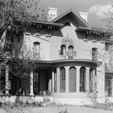
Cleydael, Historic plantation house in King George County, Virginia, United States.

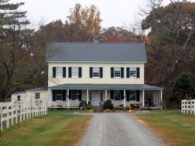
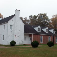
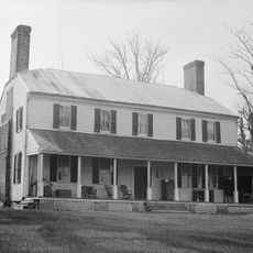
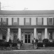
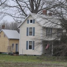
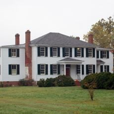
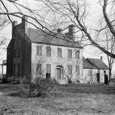
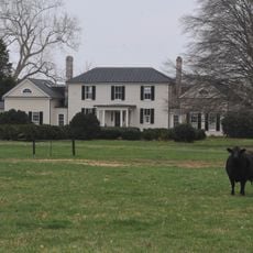
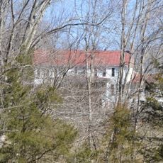
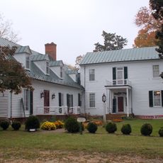
Cleydael is a two-story timber dwelling with five bays, a metal gable roof, and a wraparound porch situated on a rural property near Weedonville in King George County. The house sits visible from VA 206 and maintains its original structural character from the period in which it was built.

The house was built in 1859 as a summer home for Dr. Richard Stuart and gained importance during the Civil War years. It became a refuge for notable figures during that era and played a role in the broader events of the conflict.

The Virginia Department of Historic Resources registered Cleydael in 1986, recognizing its architectural features and connection to significant Civil War period events.

The residence is privately owned and closed to public access but can be viewed from the roadside. Visitors should maintain a respectful distance from the property and observe it from nearby road areas.

In April 1865 John Wilkes Booth came to the property seeking medical care, but Dr. Stuart refused to treat him. This encounter happened just days after President Lincoln's death and remains an overlooked detail in postwar history.

The community of curious travelers

AroundUs brings together thousands of curated places, local tips, and hidden gems, enriched daily by 60,000 contributors worldwide.

Start exploring
Location
GPS coordinates
38.31310,-77.13390
Latest update
December 14, 2025 18:02
Around this place
Morgantown Generating Station
United States of America

Morgantown Generating Station

15.1 km
Bell House
United States of America

Bell House

17.3 km
Caledon State Park
United States of America

Caledon State Park

4.4 km
James Monroe Family Home Site
United States of America

James Monroe Family Home Site

14.8 km
Crow's Nest Natural Area Preserve
United States of America

Crow's Nest Natural Area Preserve

18.4 km
Chapel Point State Park
United States of America

Chapel Point State Park

20.3 km
Camden
United States of America

Camden

16.9 km
Belle Plains, Virginia
United States of America

Belle Plains, Virginia

17.5 km
St. Paul's Episcopal Church
United States of America

St. Paul's Episcopal Church

2.2 km
Emmanuel Episcopal Church
United States of America

Emmanuel Episcopal Church

15.6 km
Christ Church
United States of America

Christ Church

19.8 km
Marmion
United States of America

Marmion

6.8 km
Gay Mont
United States of America

Gay Mont

18.1 km
Powhatan Rural Historic District
United States of America

Powhatan Rural Historic District

9.9 km
Rokeby
United States of America

Rokeby

10.9 km
Mathias Point Light
United States of America

Mathias Point Light

13 km
Eagle's Nest
United States of America

Eagle's Nest

7 km
Woodlawn Historic and Archeological District
United States of America

Woodlawn Historic and Archeological District

14.8 km
St. Peter's Episcopal Church
United States of America

St. Peter's Episcopal Church

18.9 km
Lower Cedar Point Light
United States of America

Lower Cedar Point Light

12.7 km
Upper Cedar Point Light
United States of America

Upper Cedar Point Light

10.9 km
Riverview
United States of America

Riverview

16.5 km
Waverley
United States of America

Waverley

15.5 km
Millbank (Port Conway, Virginia)
United States of America

Millbank (Port Conway, Virginia)

14.2 km
Clifton
United States of America

Clifton

18.1 km
Townfield
United States of America

Townfield

16.6 km
Dahlgren Heritage Museum
United States of America

Dahlgren Heritage Museum

11.3 km
Mallows Bay – Potomac River National Marine Sanctuary
United States of America

Mallows Bay – Potomac River National Marine Sanctuary

20.1 km
Show the full map
« Cleydael - Historic plantation house in King George County, Virginia, United States » is provided by Around Us (aroundus.com). Images and texts are derived from Wikimedia project under a Creative Commons license. You are allowed to copy, distribute, and modify copies of this page, under the conditions set by the license, as long as this note is clearly visible.

Discover hidden gems everywhere you go!

From secret cafés to breathtaking viewpoints, skip the crowded tourist spots and find places that match your style. Our app makes it easy with voice search, smart filtering, route optimization, and insider tips from travelers worldwide. Download now for the complete mobile experience.

Around Us App Screenshot

A unique approach to discovering new places

Le Figaro

All the places worth exploring

France Info

A tailor-made excursion in just a few clicks

20 Minutes

Around Us
Travel Guide & Maps
Download

Send to your phone

QR Code
1

Open the camera app on your mobile.

2

Point at the QR code with your camera. A notification will appear.

3

Tap the notification to open the link.