Trempealeau Mountain State Natural Area

Log in to your account

AroundUs is a community-driven map of interesting places, built by curious explorers like you. It grows with every review, story, and photo you share.
Connect to save your favorite spots, contribute locations, and create personalized routes.
Continue with Google
Continue with Apple
Continue with X
Continue with Facebook
Continue with email
By continuing, you accept our Terms and Conditions and our Privacy Policy
Create an account

Trempealeau Mountain State Natural Area

Add to collection
Map
Suggest a change
Share

Trempealeau Mountain State Natural Area, Protected natural area on a rock mound in Trempealeau County, Wisconsin, US.

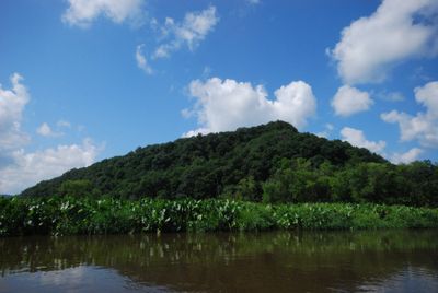
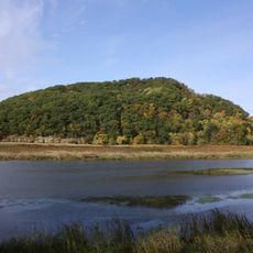
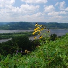
Trempealeau Mountain is a cone-shaped rocky formation rising about 425 feet above the flat surrounding landscape, completely surrounded by the Mississippi and Trempealeau Rivers in western Wisconsin. The 90-acre natural area features marked hiking trails that wind through forests and meadows with diverse plant communities.

French explorers gave this place its name, meaning 'mountain whose foot is bathed in water', when they traveled the Mississippi River in the early colonial period. The area was inhabited by indigenous peoples for centuries before European contact, as evidenced by archaeological remains throughout the location.

The mountain served as a sacred place for Native American peoples who left behind burial grounds that visitors can still observe today across the area. This landscape held spiritual and practical meaning as a gathering point connected to the two surrounding rivers.

The natural area is most easily accessed by water routes through the rivers or by approaching from nearby roads on the surrounding mainland. Wear sturdy footwear for hiking on the forest trails and plan time to explore the different pathways at a comfortable pace.

This mountain stands as one of only three solid rock islands found anywhere along the entire Mississippi River system. Its geological formation makes it particularly rare and noteworthy among river landmarks.

GPS coordinates: 44.02140,-91.49420

Latest update: December 14, 2025 09:40

Photos
Around this place
Perrot State Park
United States of America

Perrot State Park

2.2 km
Great River Bluffs State Park
United States of America

Great River Bluffs State Park

11.3 km
Basilica of Saint Stanislaus Kostka
United States of America

Basilica of Saint Stanislaus Kostka

10.6 km
Merchants National Bank
United States of America

Merchants National Bank

11.8 km
Gale College
United States of America

Gale College

12 km
Willard Bunnell House
United States of America

Willard Bunnell House

5.2 km
Lock and Dam No. 6
United States of America

Lock and Dam No. 6

5.1 km
Cathedral of the Sacred Heart
United States of America

Cathedral of the Sacred Heart

12 km
Trempealeau National Wildlife Refuge
United States of America

Trempealeau National Wildlife Refuge

6.6 km
Watkins Manor House
United States of America

Watkins Manor House

11.7 km
Winona Masonic Temple
United States of America

Winona Masonic Temple

12.1 km
Pickwick Mill
United States of America

Pickwick Mill

4.6 km
Winona Savings Bank Building
United States of America

Winona Savings Bank Building

12 km
Winona Rail Bridge
United States of America

Winona Rail Bridge

9.1 km
Laird, Norton Company Building
United States of America

Laird, Norton Company Building

12.1 km
Fort Trempealeau
United States of America

Fort Trempealeau

1.8 km
Latsch Building
United States of America

Latsch Building

11.7 km
Brady's Bluff Prairie State Natural Area
United States of America

Brady's Bluff Prairie State Natural Area

862 m
Choate Department Store
United States of America

Choate Department Store

11.9 km
Grain and Lumber Exchange Building
United States of America

Grain and Lumber Exchange Building

11.9 km
Coman House
United States of America

Coman House

5.2 km
Schlitz Hotel
United States of America

Schlitz Hotel

12.1 km
Winona City Hall
United States of America

Winona City Hall

11.8 km
Washington–Kosciusko Elementary School
United States of America

Washington–Kosciusko Elementary School

10.3 km
Polish Cultural Institute and Museum
United States of America

Polish Cultural Institute and Museum

11.2 km
Anger's Block
United States of America

Anger's Block

11.7 km
Main Street Historic District
United States of America

Main Street Historic District

4.5 km
Pickwick Mill Inc
United States of America

Pickwick Mill Inc

4.6 km
Show the full map
Reviews

Visited this place? Tap the stars to rate it and share your experience / photos with the community! Try now! You can cancel it anytime.

« Trempealeau Mountain State Natural Area - Protected natural area on a rock mound in Trempealeau County, Wisconsin, US » is provided by Around Us (aroundus.com). Images and texts are derived from Wikimedia project under a Creative Commons license. You are allowed to copy, distribute, and modify copies of this page, under the conditions set by the license, as long as this note is clearly visible.

Discover hidden gems everywhere you go!

From secret cafés to breathtaking viewpoints, skip the crowded tourist spots and find places that match your style. Our app makes it easy with voice search, smart filtering, route optimization, and insider tips from travelers worldwide. Download now for the complete mobile experience.

Around Us App Screenshot

A unique approach to discovering new places

Le Figaro

All the places worth exploring

France Info

A tailor-made excursion in just a few clicks

20 Minutes