Chest opened
+${chestReward.xp} XP
Explorer
NOUVEAU ×${chestReward.collectible.quantity}
tapez pour fermer
Chest locked

Open chests in the app

Around Us is built for your phone — chests unlock when you walk, explore and capture nearby places.

Enable Location

We need your location to show you interesting places around you

Discover nearby places

Find interesting locations and hidden gems around you

Precise directions

Get accurate directions and distances to places

Your location is never shared with other users. It's only used when you tap the location button.

Log in to your account

Start exploring — it's free

Trusted by 73,018 travelers worldwide

Continue with Google
Continue with Apple
or

We will send you a code to connect

By continuing, you accept our Terms and Conditions and our Privacy Policy

Check your inbox

We've sent a pincode in your inbox. Please enter the code below.

Scroggins Draw, Reeves County, Texas
Discussion Reviews Photo
30+ Popularity

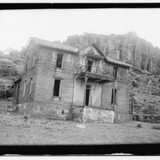
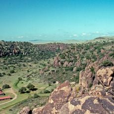
Scroggins Draw, Reeves County, Texas, Natural stream valley in Reeves County, Texas.

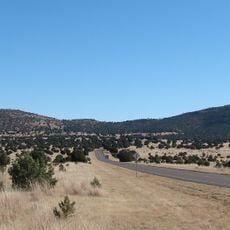
Scroggins Draw is a natural stream valley in Reeves County that cuts through the desert landscape of West Texas, functioning as a drainage system for runoff water. The valley forms a visible channel in the otherwise flat terrain, where occasional rainfall collects and flows through before soaking into the ground.

The draw has been a water source for ranching since the early settlement of Reeves County, helping cattle operations thrive in an otherwise arid region. It served as a natural stopping point for herds and provided crucial moisture during dry seasons.

The draw is woven into how local residents talk about their land and its features, serving as a reference point in everyday conversations about the region. Ranchers and families who work in the area view it as part of their connection to this corner of West Texas.

The valley can be reached by driving along rural roads from the town of Balmorhea to the east, which is the nearest populated area with services and supplies. Visitors should bring plenty of water and sun protection, as the area offers no facilities or shade.

The valley supports plant and animal species adapted to occasional water flow, creating a small but distinct ecosystem that stands out from the surrounding desert. This seasonal water presence allows vegetation to thrive in pockets along the channel, attracting wildlife that would not survive in the drier areas nearby.

The community of curious travelers

AroundUs brings together thousands of curated places, local tips, and hidden gems, enriched daily by 60,000 contributors worldwide.

Start exploring
GPS coordinates
31.09250,-104.05250
Latest update
December 11, 2025 18:03
Around this place
McDonald Observatory
United States of America

McDonald Observatory

47 km
Balmorhea State Park
United States of America

Balmorhea State Park

30.5 km
Davis Mountains State Park
United States of America

Davis Mountains State Park

56.5 km
Hobby–Eberly Telescope
United States of America

Hobby–Eberly Telescope

45.9 km
Harlan J. Smith Telescope
United States of America

Harlan J. Smith Telescope

46.9 km
Otto Struve Telescope
United States of America

Otto Struve Telescope

46.9 km
United States of America

Limpia Canyon

45.8 km
Frank N. Bash Visitors Center
United States of America

Frank N. Bash Visitors Center

46 km
United States of America

Red Point

17.4 km
United States of America

Deep Sky Observatory Collaborative

56.2 km
Fort Davis VLBA station
United States of America

Fort Davis VLBA station

52 km
United States of America

McDonald Observatory-LCO ELP

46.1 km
United States of America

McDonald Observatory-LCO ELP Aqawan A #1

46 km
United States of America

McDonald Observatory-LCO ELP B

46.1 km
United States of America

Prude Ranch observatory

54.5 km
United States of America

Divine Creation Observatory

56.2 km
Rebecca Gale Telescope Park Amphitheater
United States of America

Rebecca Gale Telescope Park Amphitheater

46.1 km
Fort Davis Quarters HB-14
United States of America

Fort Davis Quarters HB-14

56.9 km
Fort Davis Magazine
United States of America

Fort Davis Magazine

56.9 km
Fort Davis Post Chapel
United States of America

Fort Davis Post Chapel

56.9 km
United States of America

Balmorhea water tower

32 km
United States of America

Scenic viewpoint

56.8 km
United States of America

Scenic viewpoint

56.6 km
United States of America

Scenic viewpoint

56.7 km
United States of America

Limpia Creek Vista

55.5 km
United States of America

Scenic viewpoint

56.7 km
United States of America

Scenic viewpoint

30.4 km
United States of America

Waterfall

15.6 km
Show the full map
Reviews
Share your experience

No review yet

Discussions
Start a discussion...

No discussion yet

« Scroggins Draw, Reeves County, Texas - Natural stream valley in Reeves County, Texas » is provided by Around Us (aroundus.com). Images and texts are derived from Wikimedia project under a Creative Commons license. You are allowed to copy, distribute, and modify copies of this page, under the conditions set by the license, as long as this note is clearly visible.

Discover hidden gems everywhere you go!

From secret cafés to breathtaking viewpoints, skip the crowded tourist spots and find places that match your style. Our app makes it easy with voice search, smart filtering, route optimization, and insider tips from travelers worldwide. Download now for the complete mobile experience.

Around Us App Screenshot

A unique approach to discovering new places

Le Figaro

All the places worth exploring

France Info

A tailor-made excursion in just a few clicks

20 Minutes

Around Us
Travel Guide & Maps
Download

Send to your phone

QR Code
1

Open the camera app on your mobile.

2

Point at the QR code with your camera. A notification will appear.

3

Tap the notification to open the link.