·

Enable Location

We need your location to show you interesting places around you

Discover nearby places

Find interesting locations and hidden gems around you

Precise directions

Get accurate directions and distances to places

Your location is never shared with other users. It's only used when you tap the location button.

Steuben County

Log in to your account

Start exploring — it's free

Trusted by 62,678 travelers worldwide

Continue with Google
Continue with Apple
or

We will send you a code to connect

By continuing, you accept our Terms and Conditions and our Privacy Policy

Check your inbox

We've sent a pincode in your inbox. Please enter the code below.

Steuben County

Steuben County, County in northeastern Indiana, United States

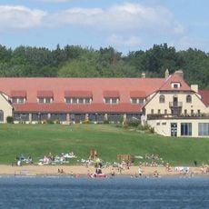
Steuben County is a county in northeastern Indiana with a landscape shaped by numerous lakes and woodlands. The area contains more than 100 lakes, several of which are part of the Pigeon River State Fish and Wildlife Area, offering opportunities for outdoor activities.

The county was established on February 7, 1835, and named after Friedrich Wilhelm von Steuben, a Prussian military officer who served in the American Revolutionary War. His name honors his role in training American army forces during that conflict.

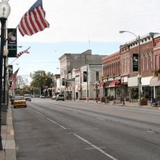
The county seat of Angola hosts regular community gatherings at the downtown square, maintaining local traditions through seasonal festivals and weekly farmers markets.

The county offers visitors good access to lakes and natural areas through multiple public parks and boat ramps throughout the region. The best time to visit is from late spring through early fall when conditions are ideal for water recreation and hiking.

The intersection of Interstate 69 and the Indiana Toll Road creates a major transportation hub, connecting the county to Chicago, Detroit, and Indianapolis.

The community of curious travelers

AroundUs brings together thousands of curated places, local tips, and hidden gems, enriched daily by 60,000 contributors worldwide.

Start exploring
Location
Inception
February 7, 1835
Capital city
Angola
Shares border with
Branch County, Hillsdale County, Williams County, DeKalb County, Noble County, LaGrange County
GPS coordinates
41.64000,-85.00000
Latest update
December 15, 2025 13:21
Around this place
Pokagon State Park
United States of America

Pokagon State Park

7.8 km
Auburn Cord Duesenberg Automobile Museum
United States of America

Auburn Cord Duesenberg Automobile Museum

32 km
Afterburner
United States of America

Afterburner

4.9 km
Powers Church
United States of America

Powers Church

13.5 km
Cornish Griffin Round Barn
United States of America

Cornish Griffin Round Barn

4.5 km
Wing House Museum
United States of America

Wing House Museum

33.3 km
Steuben County Courthouse
United States of America

Steuben County Courthouse

653 m
Eckhart Public Library and Park
United States of America

Eckhart Public Library and Park

31.1 km
Enos Michael House
United States of America

Enos Michael House

11.6 km
Downtown Auburn Historic District
United States of America

Downtown Auburn Historic District

30.8 km
Lanphere-Pratt House
United States of America

Lanphere-Pratt House

33.1 km
Kendallville Downtown Historic District
United States of America

Kendallville Downtown Historic District

31.1 km
Auburn Community Mausoleum
United States of America

Auburn Community Mausoleum

30.8 km
Angola Commercial Historic District
United States of America

Angola Commercial Historic District

588 m
Waterloo Community Mausoleum
United States of America

Waterloo Community Mausoleum

22.7 km
Abram C. Fisk House
United States of America

Abram C. Fisk House

33 km
Collins School
United States of America

Collins School

12.9 km
William L. Lords House
United States of America

William L. Lords House

17.7 km
Joseph Bowman Farmhouse
United States of America

Joseph Bowman Farmhouse

30 km
Downtown Butler Historic District
United States of America

Downtown Butler Historic District

25.8 km
Maria and Franklin Wiltrout Polygonal Barn
United States of America

Maria and Franklin Wiltrout Polygonal Barn

24.6 km
DeKalb County Home and Barn
United States of America

DeKalb County Home and Barn

29.7 km
Ezra E. and Florence Beardsley House
United States of America

Ezra E. and Florence Beardsley House

31.4 km
Pokagon Nature Center
United States of America

Pokagon Nature Center

8 km
Rakestraw House
United States of America

Rakestraw House

31.2 km
Little River Railroad
United States of America

Little River Railroad

32.8 km
Nettle Lake Mound Group
United States of America

Nettle Lake Mound Group

23 km
Strand Theatre
United States of America

Strand Theatre

614 m
Show the full map
Administrative divisions
« Steuben County - County in northeastern Indiana, United States » is provided by Around Us (aroundus.com). Images and texts are derived from Wikimedia project under a Creative Commons license. You are allowed to copy, distribute, and modify copies of this page, under the conditions set by the license, as long as this note is clearly visible.

Discover hidden gems everywhere you go!

From secret cafés to breathtaking viewpoints, skip the crowded tourist spots and find places that match your style. Our app makes it easy with voice search, smart filtering, route optimization, and insider tips from travelers worldwide. Download now for the complete mobile experience.

Around Us App Screenshot

A unique approach to discovering new places

Le Figaro

All the places worth exploring

France Info

A tailor-made excursion in just a few clicks

20 Minutes

Around Us
Travel Guide & Maps
Download

Send to your phone

QR Code
1

Open the camera app on your mobile.

2

Point at the QR code with your camera. A notification will appear.

3

Tap the notification to open the link.