Enable Location

We need your location to show you interesting places around you

Discover nearby places

Find interesting locations and hidden gems around you

Precise directions

Get accurate directions and distances to places

Your location is never shared with other users. It's only used when you tap the location button.

Old Plata Bridge

Log in to your account

Start exploring — it's free

Trusted by 63,226 travelers worldwide

Continue with Google
Continue with Apple
or

We will send you a code to connect

By continuing, you accept our Terms and Conditions and our Privacy Policy

Check your inbox

We've sent a pincode in your inbox. Please enter the code below.

Discussion Reviews 1 Photos
1.4k Popularity

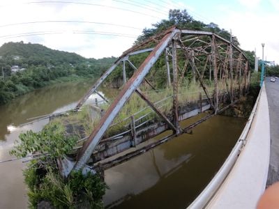
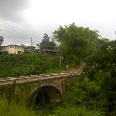
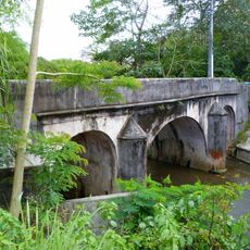
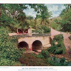
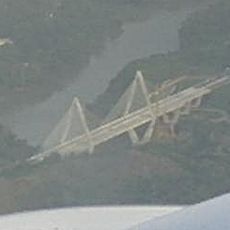
Old Plata Bridge, Road bridge between Bayamón and Naranjito, Puerto Rico

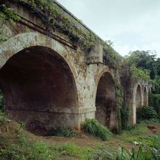
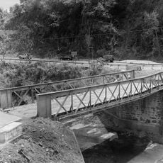
The Old Plata Bridge is a road bridge spanning the Rio La Plata between Bayamón and Naranjito, featuring two steel truss spans resting on massive masonry supports. These supports rise prominently from the riverbed and form the structural foundation for the crossing.

The bridge was built in 1908 by the American Bridge Company to connect mountain towns with the coastal road network. It remained in service for over a century, becoming part of Puerto Rico's early infrastructure development.

The bridge represents the last remaining large multi-span truss bridge in Puerto Rico and received recognition on the National Register of Historic Places in 1995.

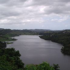
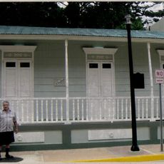
The bridge site is viewable from the Rio La Plata area and was historically an important crossing point between the two municipalities. Visitors can examine the structure today, though direct passage across it is no longer available.

The bridge construction formed part of Puerto Rico's first public works bond issue, which raised $1 million for infrastructure improvements in 1908.

The community of curious travelers

AroundUs brings together thousands of curated places, local tips, and hidden gems, enriched daily by 60,000 contributors worldwide.

Start exploring
Location
Location
GPS coordinates
18.30528,-66.21167
Latest update
December 14, 2025 17:02
Around this place
El Yunque National Forest
United States of America

El Yunque National Forest

45.3 km
Hiram Bithorn Stadium
Puerto Rico

Hiram Bithorn Stadium

19.2 km
Roberto Clemente Coliseum
United States of America

Roberto Clemente Coliseum

18.9 km
Caparra Ruins
United States of America

Caparra Ruins

15.2 km
Puerto Rico National Cemetery
United States of America

Puerto Rico National Cemetery

12.8 km
San Juan Botanical Garden
United States of America

San Juan Botanical Garden

19 km
El Cañuelo
United States of America

El Cañuelo

19.6 km
United States of America

San Patricio State Forest

17.1 km
La Plata Lake
United States of America

La Plata Lake

3.1 km
Bayamón Soccer Complex
United States of America

Bayamón Soccer Complex

8.3 km
Mavilla Bridge
United States of America

Mavilla Bridge

10.4 km
United States of America

Old Piedras River Aqueduct

18.6 km
Inmaculada Concepción Church
United States of America

Inmaculada Concepción Church

17.4 km
General Norzagaray Bridge
United States of America

General Norzagaray Bridge

13.7 km
Vega State Forest
United States of America

Vega State Forest

19.2 km
Museum of Transportation of Puerto Rico
United States of America

Museum of Transportation of Puerto Rico

11.8 km
William Miranda Marín Botanical and Cultural Garden
United States of America

William Miranda Marín Botanical and Cultural Garden

20 km
Dr. Agustín Stahl Stamm House
United States of America

Dr. Agustín Stahl Stamm House

12 km
Río Piedras Bridge
United States of America

Río Piedras Bridge

19.2 km
Bayamón City Hall
United States of America

Bayamón City Hall

11.7 km
José Celso Barbosa House Museum
United States of America

José Celso Barbosa House Museum

12.1 km
Puente No. 6
United States of America

Puente No. 6

18 km
Casa Natal de Luis Muñoz Rivera
United States of America

Casa Natal de Luis Muñoz Rivera

16.5 km
Río Hondo Bridge
United States of America

Río Hondo Bridge

11.2 km
Al-Faruq Mosque
United States of America

Al-Faruq Mosque

20 km
Cascada Charco Prieto
Puerto Rico

Cascada Charco Prieto

3.8 km
Jesús Izcoa Moure Bridge
United States of America

Jesús Izcoa Moure Bridge

2.1 km
Our Lady of the Pillar Church
United States of America

Our Lady of the Pillar Church

19.8 km
Show the full map
Reviews
Share your experience

No review yet

Discussions
Start a discussion...

No discussion yet

« Old Plata Bridge - Road bridge between Bayamón and Naranjito, Puerto Rico » is provided by Around Us (aroundus.com). Images and texts are derived from Wikimedia project under a Creative Commons license. You are allowed to copy, distribute, and modify copies of this page, under the conditions set by the license, as long as this note is clearly visible.

Discover hidden gems everywhere you go!

From secret cafés to breathtaking viewpoints, skip the crowded tourist spots and find places that match your style. Our app makes it easy with voice search, smart filtering, route optimization, and insider tips from travelers worldwide. Download now for the complete mobile experience.

Around Us App Screenshot

A unique approach to discovering new places

Le Figaro

All the places worth exploring

France Info

A tailor-made excursion in just a few clicks

20 Minutes

Around Us
Travel Guide & Maps
Download

Send to your phone

QR Code
1

Open the camera app on your mobile.

2

Point at the QR code with your camera. A notification will appear.

3

Tap the notification to open the link.