Enable Location

We need your location to show you interesting places around you

Discover nearby places

Find interesting locations and hidden gems around you

Precise directions

Get accurate directions and distances to places

Your location is never shared with other users. It's only used when you tap the location button.

Fort Saratoga

Log in to your account

Start exploring — it's free

Trusted by 61,654 travelers worldwide

Continue with Google
Continue with Apple
or

We will send you a code to connect

By continuing, you accept our Terms and Conditions and our Privacy Policy

Check your inbox

We've sent a pincode in your inbox. Please enter the code below.

Fort Saratoga

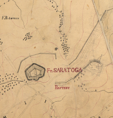
Fort Saratoga, Civil War fort in Northeast Washington, D.C., United States

Description

Fort Saratoga was a military fort in Northeast Washington, D.C., built as part of the defensive ring protecting the capital during the Civil War. The installation stood on high ground between two neighboring forts and was equipped with earthen ramparts and artillery pieces to defend against attack.

History

The fort was built in August 1861 by the 112th Pennsylvania volunteer infantry as part of hasty fortification efforts to protect Washington from attack. It was one of dozens of forts constructed in the early war years to create a defensive line around the city.

Culture

Several military units, including the Pennsylvania Regiment, District of Columbia Infantry, and New Hampshire Heavy Artillery, maintained the fort's defensive capabilities.

Practical

No structures or visible remains of the fort survive today, as the site is now part of a residential neighborhood near Rhode Island Avenue. Visitors interested in exploring the location should be aware there are no original structures or visitor facilities on the grounds.

Did you know?

The fort was armed with a mix of cannons including older smoothbore models and newer rifled artillery pieces. This hodgepodge of weapons shows how hastily the Union had to improvise its defenses, often using whatever equipment was available from existing supplies.

Location
Inception
1861
Part of
Civil War defenses of Washington, D.C.
GPS coordinates
38.92944,-76.97833
Latest update
December 14, 2025 09:42

AroundUs brings together thousands of curated places, local tips, and hidden gems, enriched daily by 60,000 contributors worldwide. Discover all places nearby (Washington, D.C.).

Around this place
Basilica of the National Shrine of the Immaculate Conception
United States of America

Basilica of the National Shrine of the Immaculate Conception

2 km
United States National Arboretum
United States of America

United States National Arboretum

2.4 km
National Capitol Columns
United States of America

National Capitol Columns

2.3 km
Northeast
United States of America

Northeast

1.9 km
Goshin
United States of America

Goshin

2.3 km
Mount St. Sepulchre Franciscan Monastery
United States of America

Mount St. Sepulchre Franciscan Monastery

1.1 km
Edgewood
United States of America

Edgewood

2 km
Newton Theater
United States of America

Newton Theater

1.3 km
Hecht Company Warehouse
United States of America

Hecht Company Warehouse

1.8 km
Fort Bunker Hill
United States of America

Fort Bunker Hill

1.1 km
St. Paul's College, Washington, D.C.
United States of America

St. Paul's College, Washington, D.C.

1.8 km
Saint Anselm's Abbey
United States of America

Saint Anselm's Abbey

1.9 km
Dance Place
United States of America

Dance Place

1.4 km
Slowe-Burrill House
United States of America

Slowe-Burrill House

927 m
Holy Redeemer College
United States of America

Holy Redeemer College

1.6 km
Brooks Mansion
United States of America

Brooks Mansion

1.4 km
Maloney Hall
United States of America

Maloney Hall

1.6 km
Alexander Crummell School
United States of America

Alexander Crummell School

1.9 km
Gibbons Hall
United States of America

Gibbons Hall

1.8 km
Ralph Bunche House
United States of America

Ralph Bunche House

482 m
Caldwell Hall
United States of America

Caldwell Hall

2 km
St Anthony of Padua Church, Washington D.C.
United States of America

St Anthony of Padua Church, Washington D.C.

1.2 km
Dahlgreen Courts
United States of America

Dahlgreen Courts

1.5 km
Children's Country Home
United States of America

Children's Country Home

1.3 km
Woodridge Neighborhood Library
United States of America

Woodridge Neighborhood Library

217 m
Mount Rainier Historic District
United States of America

Mount Rainier Historic District

1.8 km
Charles Richard Drew Memorial Bridge
United States of America

Charles Richard Drew Memorial Bridge

1.5 km
National Bonsai and Penjing Museum
United States of America

National Bonsai and Penjing Museum

2.1 km
Show the full map
« Fort Saratoga - Civil War fort in Northeast Washington, D.C., United States » is provided by Around Us (aroundus.com). Images and texts are derived from Wikimedia project under a Creative Commons license. You are allowed to copy, distribute, and modify copies of this page, under the conditions set by the license, as long as this note is clearly visible.

Discover hidden gems everywhere you go!

From secret cafés to breathtaking viewpoints, skip the crowded tourist spots and find places that match your style. Our app makes it easy with voice search, smart filtering, route optimization, and insider tips from travelers worldwide. Download now for the complete mobile experience.

Around Us App Screenshot

A unique approach to discovering new places

Le Figaro

All the places worth exploring

France Info

A tailor-made excursion in just a few clicks

20 Minutes

Around Us
Travel Guide & Maps
Download

Send to your phone

QR Code
1

Open the camera app on your mobile.

2

Point at the QR code with your camera. A notification will appear.

3

Tap the notification to open the link.