Enable Location

We need your location to show you interesting places around you

Discover nearby places

Find interesting locations and hidden gems around you

Precise directions

Get accurate directions and distances to places

Your location is never shared with other users. It's only used when you tap the location button.

Northwest Cannabis Solutions Satsop facility

Log in to your account

Start exploring — it's free

Trusted by 61,551 travelers worldwide

Continue with Google
Continue with Apple
or

We will send you a code to connect

By continuing, you accept our Terms and Conditions and our Privacy Policy

Check your inbox

We've sent a pincode in your inbox. Please enter the code below.

Northwest Cannabis Solutions Satsop facility

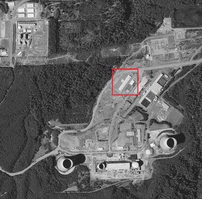
Northwest Cannabis Solutions Satsop facility, Industrial building in Satsop, United States

Description

Northwest Cannabis Solutions operates within a converted industrial park that was once designed for nuclear power development. The two-story facility utilizes existing infrastructure originally built to support large-scale energy production.

History

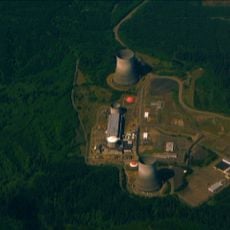
This site was part of the Washington Nuclear Project 3, which stopped construction in 1983 after reaching about three-quarters completion due to budget constraints. The location remained largely inactive for decades before being redeveloped for commercial use.

Culture

The shift from nuclear operations to cannabis production shows how Washington state's industry has changed after marijuana became legal. This reuse of an old site reflects the region's approach to breathing new life into abandoned industrial spaces.

Practical

The facility is located within an established business park with industrial infrastructure and security systems already in place. Access is typically restricted since this is a private operating site.

Did you know?

The production facility operates inside concrete structures that were originally designed to survive nuclear reactions, giving the space exceptional structural strength. This robust construction provides long-term reliability for ongoing operations.

Inception
1980
Floors above the ground
2
GPS coordinates
46.96550,-123.46860
Latest update
December 12, 2025 17:44

AroundUs brings together thousands of curated places, local tips, and hidden gems, enriched daily by 60,000 contributors worldwide. Discover all places nearby (United States of America).

Around this place
WNP-3 and WNP-5
United States of America

WNP-3 and WNP-5

735 m
Mima Mounds
United States of America

Mima Mounds

32.7 km
Young Street Bridge
United States of America

Young Street Bridge

25.6 km
Capitol State Forest
United States of America

Capitol State Forest

22.7 km
Mima Mounds Natural Area Preserve
United States of America

Mima Mounds Natural Area Preserve

32.7 km
Lake Sylvia State Park
United States of America

Lake Sylvia State Park

10 km
Summit Lake
United States of America

Summit Lake

29.5 km
Schafer State Park
United States of America

Schafer State Park

14.5 km
Grays Harbor National Wildlife Refuge
United States of America

Grays Harbor National Wildlife Refuge

35.1 km
Hoquiam's Castle
United States of America

Hoquiam's Castle

31.9 km
Kennedy Creek Natural Area Preserve
United States of America

Kennedy Creek Natural Area Preserve

33.2 km
7th Street Theatre
United States of America

7th Street Theatre

31.7 km
Capitol Peak
United States of America

Capitol Peak

25.1 km
Mud Bay Indian Shaker Church
United States of America

Mud Bay Indian Shaker Church

35.9 km
Joseph Lytle House
United States of America

Joseph Lytle House

32.1 km
Carnegie Library
United States of America

Carnegie Library

31.7 km
Sierra
United States of America

Sierra

25.2 km
Masonic Temple-Hoquiam
United States of America

Masonic Temple-Hoquiam

31.8 km
Raymond Theatre
United States of America

Raymond Theatre

36.9 km
Wishkah River Bridge
United States of America

Wishkah River Bridge

26.1 km
Riverside Avenue Bridge
United States of America

Riverside Avenue Bridge

31.6 km
Satsop River Bridges
United States of America

Satsop River Bridges

4.2 km
Chehalis River Bridge
United States of America

Chehalis River Bridge

25.9 km
Olympic Stadium
United States of America

Olympic Stadium

29.7 km
Elma Theater
United States of America

Elma Theater

6.5 km
D & R Theatre
United States of America

D & R Theatre

26.5 km
Montesano Theater
United States of America

Montesano Theater

10.3 km
Schafer State Park Day-Use Area Comfort Station
United States of America

Schafer State Park Day-Use Area Comfort Station

14.7 km
Show the full map
« Northwest Cannabis Solutions Satsop facility - Industrial building in Satsop, United States » is provided by Around Us (aroundus.com). Images and texts are derived from Wikimedia project under a Creative Commons license. You are allowed to copy, distribute, and modify copies of this page, under the conditions set by the license, as long as this note is clearly visible.

Discover hidden gems everywhere you go!

From secret cafés to breathtaking viewpoints, skip the crowded tourist spots and find places that match your style. Our app makes it easy with voice search, smart filtering, route optimization, and insider tips from travelers worldwide. Download now for the complete mobile experience.

Around Us App Screenshot

A unique approach to discovering new places

Le Figaro

All the places worth exploring

France Info

A tailor-made excursion in just a few clicks

20 Minutes

Around Us
Travel Guide & Maps
Download

Send to your phone

QR Code
1

Open the camera app on your mobile.

2

Point at the QR code with your camera. A notification will appear.

3

Tap the notification to open the link.