Enable Location

We need your location to show you interesting places around you

Discover nearby places

Find interesting locations and hidden gems around you

Precise directions

Get accurate directions and distances to places

Your location is never shared with other users. It's only used when you tap the location button.

New Hampton Pony Pratt Truss Bridge

Log in to your account

Start exploring — it's free

Trusted by 62,347 travelers worldwide

Continue with Google
Continue with Apple
or

We will send you a code to connect

By continuing, you accept our Terms and Conditions and our Privacy Policy

Check your inbox

We've sent a pincode in your inbox. Please enter the code below.

New Hampton Pony Pratt Truss Bridge

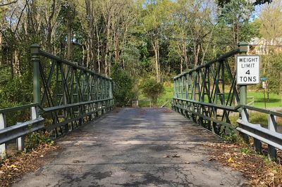
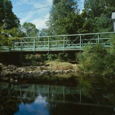
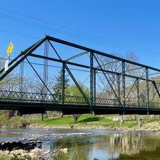
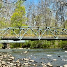
New Hampton Pony Pratt Truss Bridge, Iron road bridge in Lebanon Township, US

The New Hampton Pony Pratt Truss Bridge is a single-span iron structure crossing the Musconetcong River between two townships. Its latticework frame design represents a common construction method used for bridges built during that era.

Francis C. Lowthorp designed this iron bridge in 1868, and William Cowin from Lambertville constructed it using methods typical of that era. The bridge emerged at a time when local craftsmanship and industrial materials first came together.

The bridge represents a period when engineering skill and local craftsmanship came together to connect communities. People in the area recognize it as a functional landmark that has served its purpose for more than 150 years.

The bridge spans across the river between two municipalities and is passable on foot or by vehicle. It helps to check a local map since the crossing sits on a back road rather than a main highway.

The structure features distinctive vertical end posts made from octagonal iron tubes topped with square decorative caps. This detail shows how even purely functional elements of a bridge received careful design attention.

The community of curious travelers

AroundUs brings together thousands of curated places, local tips, and hidden gems, enriched daily by 60,000 contributors worldwide.

Start exploring
Location
Inception
1868
GPS coordinates
40.72056,-74.96361
Latest update
December 14, 2025 18:46
Around this place
Spruce Run Recreation Area
United States of America

Spruce Run Recreation Area

6.8 km
Voorhees State Park
United States of America

Voorhees State Park

7 km
United States of America

Musconetcong Mountain

7.9 km
Ken Lockwood Gorge Bridge
United States of America

Ken Lockwood Gorge Bridge

8.1 km
Oxford Furnace
United States of America

Oxford Furnace

9.7 km
Perryville Tavern
United States of America

Perryville Tavern

9.8 km
Asbury Historic District
United States of America

Asbury Historic District

4.9 km
Port Murray Historic District
United States of America

Port Murray Historic District

9 km
Paul Robinson Observatory
United States of America

Paul Robinson Observatory

7 km
Port Colden Historic District
United States of America

Port Colden Historic District

5 km
Glen Gardner Pony Pratt Truss Bridge
United States of America

Glen Gardner Pony Pratt Truss Bridge

2.7 km
First Methodist Episcopal Church
United States of America

First Methodist Episcopal Church

4.4 km
Hoffman's Crossing Road Bridge
United States of America

Hoffman's Crossing Road Bridge

8.8 km
Imlaydale Historic District
United States of America

Imlaydale Historic District

935 m
Miller Farmstead
United States of America

Miller Farmstead

9.3 km
Spruce Run Evangelical Lutheran Zion Church
United States of America

Spruce Run Evangelical Lutheran Zion Church

3.7 km
New Hampton Historic District
United States of America

New Hampton Historic District

278 m
Oxford Industrial Historic District
United States of America

Oxford Industrial Historic District

9.1 km
Asbury United Methodist Church
United States of America

Asbury United Methodist Church

4.8 km
Union Forge Bridge
United States of America

Union Forge Bridge

8.6 km
Spruce Run Reservoir
United States of America

Spruce Run Reservoir

8 km
1760 Joseph Turner House
United States of America

1760 Joseph Turner House

7.1 km
Lake Solitude
United States of America

Lake Solitude

8.4 km
Readingsburg Historic District
United States of America

Readingsburg Historic District

8.4 km
Van Syckel Corner District
United States of America

Van Syckel Corner District

8 km
Pleasant Valley Historic District
United States of America

Pleasant Valley Historic District

4.8 km
Bowerstown Historic District
United States of America

Bowerstown Historic District

6.5 km
Solitude House
United States of America

Solitude House

8.5 km
Show the full map
« New Hampton Pony Pratt Truss Bridge - Iron road bridge in Lebanon Township, US » is provided by Around Us (aroundus.com). Images and texts are derived from Wikimedia project under a Creative Commons license. You are allowed to copy, distribute, and modify copies of this page, under the conditions set by the license, as long as this note is clearly visible.

Discover hidden gems everywhere you go!

From secret cafés to breathtaking viewpoints, skip the crowded tourist spots and find places that match your style. Our app makes it easy with voice search, smart filtering, route optimization, and insider tips from travelers worldwide. Download now for the complete mobile experience.

Around Us App Screenshot

A unique approach to discovering new places

Le Figaro

All the places worth exploring

France Info

A tailor-made excursion in just a few clicks

20 Minutes

Around Us
Travel Guide & Maps
Download

Send to your phone

QR Code
1

Open the camera app on your mobile.

2

Point at the QR code with your camera. A notification will appear.

3

Tap the notification to open the link.