Houghton Lake Flats Flooding State Wildlife Management Area

Log in to your account

AroundUs is a community-driven map of interesting places, built by curious explorers like you. It grows with every review, story, and photo you share.
Connect to save your favorite spots, contribute locations, and create personalized routes.
By continuing, you accept our Terms and Conditions and our Privacy Policy

Houghton Lake Flats Flooding State Wildlife Management Area

Add to collection
Map
Suggest a change
Share

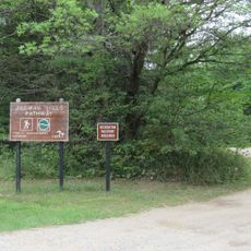
Houghton Lake Flats Flooding State Wildlife Management Area, Wildlife management area in Lake Township, Michigan, US

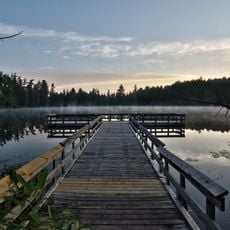
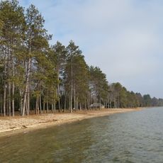
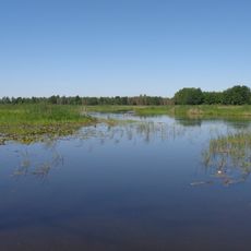
The Houghton Lake Flats Flooding State Wildlife Management Area is a protected region of restored marshes and wetlands separated into northern and southern sections. The landscape features open water bodies, reeds, and grasslands that create diverse habitats for birds and fish.

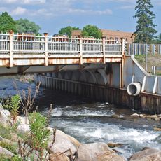
The area was formed when the Reedsburg Dam was constructed in 1940, creating a reservoir called Dead Stream Flooding in this location. The restoration of wetlands in later years transformed it into a dedicated wildlife protection area.

This protected land serves as a vital stopover and home for migratory birds and waterfowl that depend on its seasonally changing habitat. The observation deck allows visitors to witness the seasonal movement of birds without disturbing their natural behaviors.

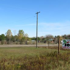
Access this area via U.S. Route 127 exits at 194 and 201, with parking available near the observation decks. Spring and fall offer the best viewing times when bird activity is most active.

The site operates through a controlled flooding system that adjusts water levels strategically to support fish populations like northern pike and largemouth bass. This active water management approach shows how land can be shaped to benefit wildlife populations.

GPS coordinates: 44.37167,-84.80806

Latest update: December 14, 2025 17:02

Photos
Around this place
Hartwick Pines State Park
United States of America

Hartwick Pines State Park

43.2 km
South Higgins Lake State Park
United States of America

South Higgins Lake State Park

12.6 km
North Higgins Lake State Park
United States of America

North Higgins Lake State Park

16.3 km
Mitchell State Park
United States of America

Mitchell State Park

53.4 km
Dead Stream Flooding State Wildlife Management Area
United States of America

Dead Stream Flooding State Wildlife Management Area

3 km
Roscommon Zoo
United States of America

Roscommon Zoo

30 km
Cadillac-Soo Lumber Company 3
United States of America

Cadillac-Soo Lumber Company 3

49.1 km
Charles T. Mitchell House
United States of America

Charles T. Mitchell House

48.9 km
Cadillac Public Library
United States of America

Cadillac Public Library

48.9 km
Frank J. Cobbs House
United States of America

Frank J. Cobbs House

48.6 km
Eggleston School
United States of America

Eggleston School

32.7 km
Edward E. Hartwick Memorial Building
United States of America

Edward E. Hartwick Memorial Building

42.8 km
Douglas House
United States of America

Douglas House

54.4 km
Elks Temple Building
United States of America

Elks Temple Building

49 km
Cobbs and Mitchell Building
United States of America

Cobbs and Mitchell Building

48.9 km
Ogemaw Hills Pathway
United States of America

Ogemaw Hills Pathway

46.4 km
M-72–Au Sable River Bridge
United States of America

M-72–Au Sable River Bridge

33 km
Masonic Temple Building
United States of America

Masonic Temple Building

49 km
Fife Lake–Union District No. 1 Schoolhouse
United States of America

Fife Lake–Union District No. 1 Schoolhouse

51 km
Ogemaw Lanes & Lounge
United States of America

Ogemaw Lanes & Lounge

48.6 km
Hi-Skore Lanes & Bar
United States of America

Hi-Skore Lanes & Bar

46.3 km
Snowbird Lanes
United States of America

Snowbird Lanes

37.6 km
CoopersVille USA
United States of America

CoopersVille USA

54.3 km
Twin Birch Golf Course
United States of America

Twin Birch Golf Course

48.9 km
Cobbs and Mitchell Mill No 1 Historical Marker
United States of America

Cobbs and Mitchell Mill No 1 Historical Marker

49.1 km
Cadillac Wexford Public Library
United States of America

Cadillac Wexford Public Library

49.1 km
Missaukee County Historical Society Museum
United States of America

Missaukee County Historical Society Museum

33.2 km
Missaukee County Veterans Memorial Park
United States of America

Missaukee County Veterans Memorial Park

32.6 km
Show the full map
Reviews

Visited this place? Tap the stars to rate it and share your experience / photos with the community! Try now! You can cancel it anytime.

« Houghton Lake Flats Flooding State Wildlife Management Area - Wildlife management area in Lake Township, Michigan, US » is provided by Around Us (aroundus.com). Images and texts are derived from Wikimedia project under a Creative Commons license. You are allowed to copy, distribute, and modify copies of this page, under the conditions set by the license, as long as this note is clearly visible.

Discover hidden gems everywhere you go!

From secret cafés to breathtaking viewpoints, skip the crowded tourist spots and find places that match your style. Our app makes it easy with voice search, smart filtering, route optimization, and insider tips from travelers worldwide. Download now for the complete mobile experience.

Around Us App Screenshot

A unique approach to discovering new places

Le Figaro

All the places worth exploring

France Info

A tailor-made excursion in just a few clicks

20 Minutes