Enable Location

We need your location to show you interesting places around you

Discover nearby places

Find interesting locations and hidden gems around you

Precise directions

Get accurate directions and distances to places

Your location is never shared with other users. It's only used when you tap the location button.

Green Lane Bridge

Log in to your account

Start exploring — it's free

Trusted by 61,668 travelers worldwide

Continue with Google
Continue with Apple
or

We will send you a code to connect

By continuing, you accept our Terms and Conditions and our Privacy Policy

Check your inbox

We've sent a pincode in your inbox. Please enter the code below.

Green Lane Bridge

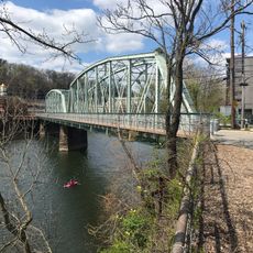
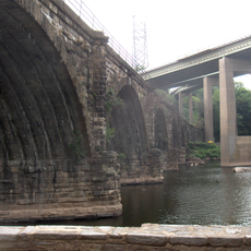
Green Lane Bridge, Concrete arch bridge in Manayunk, United States

Description

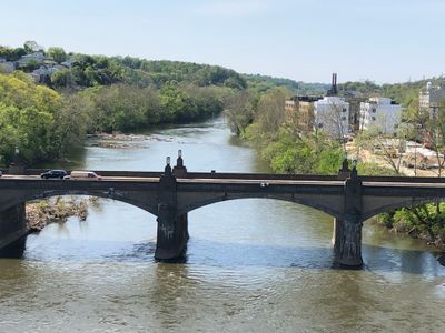
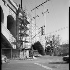
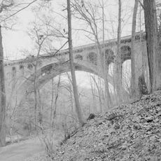
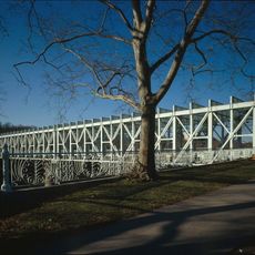
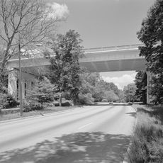
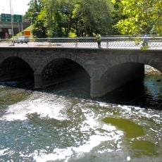
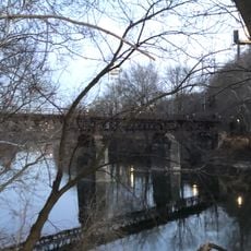
Green Lane Bridge is a concrete arch structure spanning the Schuylkill River and joining Manayunk with Belmont Hills. Its 36-foot (11-meter) wide roadway carries traffic across the water in a distinctive arched form that has become a recognizable part of the landscape.

History

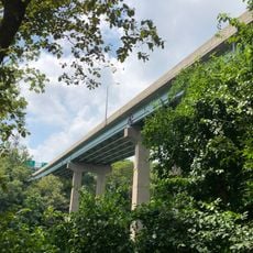
Architect Paul Philippe Cret designed the bridge in 1928 using advanced concrete arch technology that was cutting-edge for its time. The design represented modern engineering methods that helped shape transportation infrastructure across the region during that era.

Culture

The bridge anchors the Manayunk area as a landmark from the era when this neighborhood thrived as an industrial and transportation hub. Today it remains a visual reminder of how the community developed and connected across the river.

Practical

The bridge carries substantial daily traffic connecting Philadelphia to Lower Merion Township, so congestion varies depending on the time of day. Pedestrians and cyclists should be aware that this is a busy roadway and care should be taken when crossing or using nearby paths.

Did you know?

The structure crosses the river while also spanning railroad tracks, a canal, and recreational paths all in a single engineering solution. This layering of multiple transportation routes beneath the roadway makes it a notable example of how infrastructure can serve different purposes simultaneously.

Location
Inception
1928
GPS coordinates
40.02623,-75.22792
Latest update
December 14, 2025 17:04

AroundUs brings together thousands of curated places, local tips, and hidden gems, enriched daily by 60,000 contributors worldwide. Discover all places nearby (Philadelphia).

Around this place
Wissahickon Valley Park
United States of America

Wissahickon Valley Park

2.2 km
Historic RittenhouseTown
United States of America

Historic RittenhouseTown

3.1 km
Wissahickon Memorial Bridge
United States of America

Wissahickon Memorial Bridge

2.7 km
Manayunk Bridge
United States of America

Manayunk Bridge

166 m
Alden Park Manor
United States of America

Alden Park Manor

3.6 km
Walnut Lane Bridge
United States of America

Walnut Lane Bridge

2.5 km
Ravenhill
United States of America

Ravenhill

2.9 km
Falls Bridge
United States of America

Falls Bridge

3.2 km
Temple Adath Israel of the Main Line
United States of America

Temple Adath Israel of the Main Line

3 km
Wynnestay
United States of America

Wynnestay

3.6 km
Chain Bridge at Falls of Schuylkill
United States of America

Chain Bridge at Falls of Schuylkill

3.7 km
Paper Mill Run
United States of America

Paper Mill Run

3.4 km
Arboretum of the Barnes Foundation
United States of America

Arboretum of the Barnes Foundation

3.4 km
Livezey House
United States of America

Livezey House

2.9 km
Walnut Lane Memorial Bridge
United States of America

Walnut Lane Memorial Bridge

3.5 km
United States of America

Paul J. Gutman Library

3.2 km
The Monastery
United States of America

The Monastery

2.3 km
Pencoyd Bridge
United States of America

Pencoyd Bridge

1.6 km
Twin Bridges
United States of America

Twin Bridges

3.7 km
St. Josaphat Roman Catholic Church in Philadelphia
United States of America

St. Josaphat Roman Catholic Church in Philadelphia

565 m
Mayfair House
United States of America

Mayfair House

3.3 km
Ridge Avenue Bridge in Philadelphia
United States of America

Ridge Avenue Bridge in Philadelphia

2.2 km
United States of America

Bala Theatre

2.4 km
City Avenue Bridges
United States of America

City Avenue Bridges

2.5 km
McCallum Manor
United States of America

McCallum Manor

3.7 km
Church of St. Alban, Roxborough
United States of America

Church of St. Alban, Roxborough

2 km
Mule Bridge
United States of America

Mule Bridge

872 m
Falls of Schuylkill Branch Library
United States of America

Falls of Schuylkill Branch Library

3.3 km
Show the full map
« Green Lane Bridge - Concrete arch bridge in Manayunk, United States » is provided by Around Us (aroundus.com). Images and texts are derived from Wikimedia project under a Creative Commons license. You are allowed to copy, distribute, and modify copies of this page, under the conditions set by the license, as long as this note is clearly visible.

Discover hidden gems everywhere you go!

From secret cafés to breathtaking viewpoints, skip the crowded tourist spots and find places that match your style. Our app makes it easy with voice search, smart filtering, route optimization, and insider tips from travelers worldwide. Download now for the complete mobile experience.

Around Us App Screenshot

A unique approach to discovering new places

Le Figaro

All the places worth exploring

France Info

A tailor-made excursion in just a few clicks

20 Minutes

Around Us
Travel Guide & Maps
Download

Send to your phone

QR Code
1

Open the camera app on your mobile.

2

Point at the QR code with your camera. A notification will appear.

3

Tap the notification to open the link.