Chest opened
+${chestReward.xp} XP
Explorer
NOUVEAU ×${chestReward.collectible.quantity}
tapez pour fermer
Chest locked

Open chests in the app

Around Us is built for your phone — chests unlock when you walk, explore and capture nearby places.

Enable Location

We need your location to show you interesting places around you

Discover nearby places

Find interesting locations and hidden gems around you

Precise directions

Get accurate directions and distances to places

Your location is never shared with other users. It's only used when you tap the location button.

Log in to your account

Start exploring — it's free

Trusted by 72,938 travelers worldwide

Continue with Google
Continue with Apple
or

We will send you a code to connect

By continuing, you accept our Terms and Conditions and our Privacy Policy

Check your inbox

We've sent a pincode in your inbox. Please enter the code below.

Bristol Cliffs Wilderness
Discussion Reviews Photo
1.2k Popularity

Bristol Cliffs Wilderness, Protected wilderness area in Addison County, Vermont, United States.

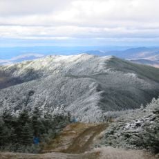
Bristol Cliffs Wilderness is a protected natural area in Vermont with steep rock formations and two secluded ponds tucked within its interior. The land is densely forested and undeveloped, with no marked trails, only faint footpaths for visitors to follow.

The area received federal protection in 1975 through wilderness legislation and underwent a major boundary change the following year. These legal steps established the protected landscape that exists today.

The quartzite formation at Devil's Pulpit held importance for Native American toolmakers who worked with this material. This connection to early human activity remains part of how people understand the place today.

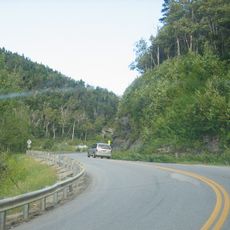
Visitors should bring maps and compass or GPS tools since the terrain is very undeveloped and navigation is challenging. Reaching the cliffs requires good fitness and preparation, particularly during wet or muddy conditions.

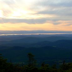
From the summit, visitors can see across the Champlain Valley to Lake Champlain and the Adirondack Mountains in New York. This expansive view connects the local wilderness to the larger landscape of the region.

The community of curious travelers

AroundUs brings together thousands of curated places, local tips, and hidden gems, enriched daily by 60,000 contributors worldwide.

Start exploring
GPS coordinates
44.10000,-73.05000
Latest update
December 14, 2025 18:40
Around this place
Mount Abraham
United States of America

Mount Abraham

9.4 km
Mount Ellen
United States of America

Mount Ellen

11.8 km
Buels Gore
United States of America

Buels Gore

14.5 km
Pulp Mill Covered Bridge
United States of America

Pulp Mill Covered Bridge

13.2 km
Emma Willard House
United States of America

Emma Willard House

14.3 km
United States of America

Breadloaf Wilderness

14.1 km
United States of America

Lincoln Peak

10.2 km
Youngman Field at Alumni Stadium
United States of America

Youngman Field at Alumni Stadium

14.9 km
Henry Sheldon Museum of Vermont History
United States of America

Henry Sheldon Museum of Vermont History

13.7 km
Halpin Covered Bridge
United States of America

Halpin Covered Bridge

9.2 km
Vermont Experimental Cold-Hardy Cactus Garden
United States of America

Vermont Experimental Cold-Hardy Cactus Garden

15.3 km
Old Stone Row
United States of America

Old Stone Row

14.3 km
Lampson School
United States of America

Lampson School

4.8 km
Middlebury Gorge Concrete Arch Bridge
United States of America

Middlebury Gorge Concrete Arch Bridge

14.8 km
Stone Mill
United States of America

Stone Mill

13.3 km
South Starksboro Friends Meeting House and Cemetery
United States of America

South Starksboro Friends Meeting House and Cemetery

8 km
Wesleyan Methodist Church
United States of America

Wesleyan Methodist Church

13.8 km
Bridge 26
United States of America

Bridge 26

11.9 km
Union Church
United States of America

Union Church

4.8 km
Brooksville Advent Church
United States of America

Brooksville Advent Church

10.6 km
The Heights
United States of America

The Heights

14.9 km
Starksboro Village Meeting House
United States of America

Starksboro Village Meeting House

14 km
Bristol Downtown Historic District
United States of America

Bristol Downtown Historic District

4.2 km
Cotton Free Library
United States of America

Cotton Free Library

13.8 km
Middlebury to Her Soldiers
United States of America

Middlebury to Her Soldiers

13.4 km
Ripton Community House
United States of America

Ripton Community House

14 km
Fenn Farm
United States of America

Fenn Farm

14.1 km
Bottum Farm
United States of America

Bottum Farm

10 km
Show the full map
Reviews
Share your experience

No review yet

Discussions
Start a discussion...

No discussion yet

« Bristol Cliffs Wilderness - Protected wilderness area in Addison County, Vermont, United States » is provided by Around Us (aroundus.com). Images and texts are derived from Wikimedia project under a Creative Commons license. You are allowed to copy, distribute, and modify copies of this page, under the conditions set by the license, as long as this note is clearly visible.

Discover hidden gems everywhere you go!

From secret cafés to breathtaking viewpoints, skip the crowded tourist spots and find places that match your style. Our app makes it easy with voice search, smart filtering, route optimization, and insider tips from travelers worldwide. Download now for the complete mobile experience.

Around Us App Screenshot

A unique approach to discovering new places

Le Figaro

All the places worth exploring

France Info

A tailor-made excursion in just a few clicks

20 Minutes

Around Us
Travel Guide & Maps
Download

Send to your phone

QR Code
1

Open the camera app on your mobile.

2

Point at the QR code with your camera. A notification will appear.

3

Tap the notification to open the link.