Enable Location

We need your location to show you interesting places around you

Discover nearby places

Find interesting locations and hidden gems around you

Precise directions

Get accurate directions and distances to places

Your location is never shared with other users. It's only used when you tap the location button.

Log in to your account

Start exploring — it's free

Trusted by 61,899 travelers worldwide

Continue with Google
Continue with Apple
or

We will send you a code to connect

By continuing, you accept our Terms and Conditions and our Privacy Policy

Check your inbox

We've sent a pincode in your inbox. Please enter the code below.

Lincoln Peak

Lincoln Peak, Mountain summit in Green Mountains, Vermont, United States

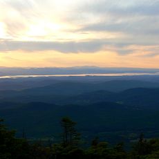
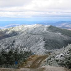
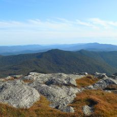
Lincoln Peak rises to 3,975 feet (1,211 meters) in the Green Mountains and features steep slopes covered in dense coniferous forest. The terrain offers several hiking routes of varying difficulty that wind through the woodland.

The mountain was named after Major General Benjamin Lincoln, who led American forces to victory at the Battle of Saratoga in 1777. His name honors his military contribution to American independence.

The Long Trail passes through Lincoln Peak and connects with several hiking routes that attract outdoor enthusiasts year-round. The mountain holds meaning for hikers as part of Vermont's hiking heritage and community traditions.

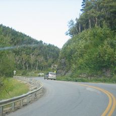
Hikers reach the summit via the Lincoln Gap Trail, a 6.3-mile (10-kilometer) route with moderate to difficult conditions and significant elevation gain. The terrain requires good footing and appropriate gear for changing seasonal conditions.

The northeast slope houses Sugarbush Resort, a popular winter sports destination. At the same time, water from the mountain feeds into the brook and river system that flows toward Lake Champlain.

The community of curious travelers

AroundUs brings together thousands of curated places, local tips, and hidden gems, enriched daily by 60,000 contributors worldwide.

Start exploring
Location
GPS coordinates
44.12697,-72.92794
Latest update
December 14, 2025 12:22
Around this place
Mount Abraham
United States of America

Mount Abraham

986 m
Mount Ellen
United States of America

Mount Ellen

3.7 km
Robert Frost Farm
United States of America

Robert Frost Farm

18.9 km
Buels Gore
United States of America

Buels Gore

9.2 km
United States of America

Breadloaf Wilderness

12.3 km
Great Eddy Covered Bridge
United States of America

Great Eddy Covered Bridge

10.9 km
Warren Covered Bridge
United States of America

Warren Covered Bridge

5.9 km
Halpin Covered Bridge
United States of America

Halpin Covered Bridge

19.1 km
Pine Brook Covered Bridge
United States of America

Pine Brook Covered Bridge

14 km
Camels Hump State Forest
United States of America

Camels Hump State Forest

7.8 km
Knoll Farm
United States of America

Knoll Farm

9.9 km
Stony Brook Covered Bridge
United States of America

Stony Brook Covered Bridge

19.1 km
Lampson School
United States of America

Lampson School

15 km
Joslin Farm
United States of America

Joslin Farm

10.5 km
South Starksboro Friends Meeting House and Cemetery
United States of America

South Starksboro Friends Meeting House and Cemetery

8.3 km
Warren Village Historic District
United States of America

Warren Village Historic District

5.9 km
Union Church
United States of America

Union Church

15 km
Mad River Valley Rural Historic District
United States of America

Mad River Valley Rural Historic District

15.1 km
Starksboro Village Meeting House
United States of America

Starksboro Village Meeting House

15.1 km
Hoag Gristmill and Knight House Complex
United States of America

Hoag Gristmill and Knight House Complex

17.2 km
Bristol Downtown Historic District
United States of America

Bristol Downtown Historic District

12 km
Ripton Community House
United States of America

Ripton Community House

19 km
Bottum Farm
United States of America

Bottum Farm

18.5 km
Remington-Williamson Farm
United States of America

Remington-Williamson Farm

19.5 km
Waitsfield Village Historic District
United States of America

Waitsfield Village Historic District

11 km
Waitsfield Common Historic District
United States of America

Waitsfield Common Historic District

12.5 km
Jones-Pestle Farmstead
United States of America

Jones-Pestle Farmstead

10.9 km
Moss Glen Falls
United States of America

Moss Glen Falls

13.6 km
Show the full map
« Lincoln Peak - Mountain summit in Green Mountains, Vermont, United States » is provided by Around Us (aroundus.com). Images and texts are derived from Wikimedia project under a Creative Commons license. You are allowed to copy, distribute, and modify copies of this page, under the conditions set by the license, as long as this note is clearly visible.

Discover hidden gems everywhere you go!

From secret cafés to breathtaking viewpoints, skip the crowded tourist spots and find places that match your style. Our app makes it easy with voice search, smart filtering, route optimization, and insider tips from travelers worldwide. Download now for the complete mobile experience.

Around Us App Screenshot

A unique approach to discovering new places

Le Figaro

All the places worth exploring

France Info

A tailor-made excursion in just a few clicks

20 Minutes

Around Us
Travel Guide & Maps
Download

Send to your phone

QR Code
1

Open the camera app on your mobile.

2

Point at the QR code with your camera. A notification will appear.

3

Tap the notification to open the link.