Enable Location

We need your location to show you interesting places around you

Discover nearby places

Find interesting locations and hidden gems around you

Precise directions

Get accurate directions and distances to places

Your location is never shared with other users. It's only used when you tap the location button.

Warren Covered Bridge

Log in to your account

Start exploring — it's free

Trusted by 61,360 travelers worldwide

Continue with Google
Continue with Apple
or

We will send you a code to connect

By continuing, you accept our Terms and Conditions and our Privacy Policy

Check your inbox

We've sent a pincode in your inbox. Please enter the code below.

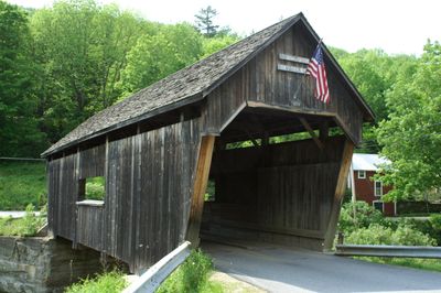
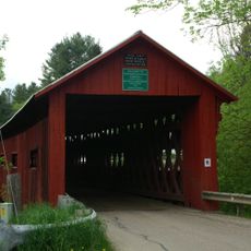
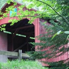
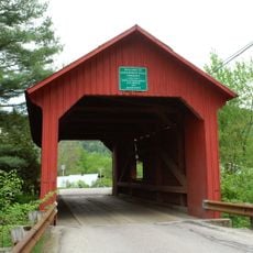
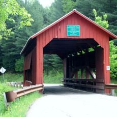
Warren Covered Bridge, Historic covered bridge in Warren, Vermont.

Description

Warren Covered Bridge is a wooden structure crossing the Mad River in Vermont with walls on both sides that protect the interior framework. The queen post truss design distributes weight and has remained intact for over a century.

History

Walter Bagley built this crossing over the Mad River in 1880 using techniques common to the era. Official recognition of its historical importance came in 1974 when it joined the National Register.

Culture

The bridge shows how the region valued practical wooden construction and protected important routes through daily use. Travelers passing through recognized the skilled craftsmanship built into local structures.

Practical

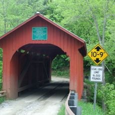
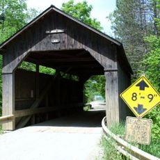
Find the bridge on Covered Bridge Road with parking near the western entrance, making it easy to access. Keep in mind the 8-ton weight limit and 10-foot clearance if driving a vehicle across.

Did you know?

The eastern end extends further over the approach road than the western end, a distinctive feature. Only one other surviving bridge in Vermont shares this asymmetrical design.

Location
GPS coordinates
44.11111,-72.85694
Latest update
December 14, 2025 13:03

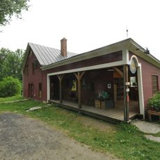
AroundUs brings together thousands of curated places, local tips, and hidden gems, enriched daily by 60,000 contributors worldwide. Discover all places nearby (Warren).

Around this place
Mount Abraham
United States of America

Mount Abraham

6.4 km
Mount Ellen
United States of America

Mount Ellen

7.9 km
Buels Gore
United States of America

Buels Gore

13.1 km
United States of America

Breadloaf Wilderness

11.5 km
Great Eddy Covered Bridge
United States of America

Great Eddy Covered Bridge

9.1 km
United States of America

Lincoln Peak

5.9 km
Allis State Park
United States of America

Allis State Park

19.1 km
Northfield Falls Covered Bridge
United States of America

Northfield Falls Covered Bridge

17.8 km
Slaughter House Covered Bridge
United States of America

Slaughter House Covered Bridge

17.4 km
Pine Brook Covered Bridge
United States of America

Pine Brook Covered Bridge

11.8 km
Camels Hump State Forest
United States of America

Camels Hump State Forest

6.3 km
Knoll Farm
United States of America

Knoll Farm

9.2 km
Stony Brook Covered Bridge
United States of America

Stony Brook Covered Bridge

13.4 km
Lower Cox Brook Covered Bridge
United States of America

Lower Cox Brook Covered Bridge

17.7 km
Lover's Lane Bridge
United States of America

Lover's Lane Bridge

19.3 km
Joslin Farm
United States of America

Joslin Farm

7.4 km
South Starksboro Friends Meeting House and Cemetery
United States of America

South Starksboro Friends Meeting House and Cemetery

14.1 km
Upper Cox Brook Covered Bridge
United States of America

Upper Cox Brook Covered Bridge

17.5 km
Warren Village Historic District
United States of America

Warren Village Historic District

279 m
Mad River Valley Rural Historic District
United States of America

Mad River Valley Rural Historic District

13.3 km
Brown Public Library
United States of America

Brown Public Library

16.6 km
Bristol Downtown Historic District
United States of America

Bristol Downtown Historic District

17.8 km
Mayo Building
United States of America

Mayo Building

16.6 km
Old Red Mill
United States of America

Old Red Mill

16 km
Waitsfield Village Historic District
United States of America

Waitsfield Village Historic District

9.3 km
Waitsfield Common Historic District
United States of America

Waitsfield Common Historic District

9.8 km
Jones-Pestle Farmstead
United States of America

Jones-Pestle Farmstead

8.9 km
Moss Glen Falls
United States of America

Moss Glen Falls

10.4 km
Show the full map
« Warren Covered Bridge - Historic covered bridge in Warren, Vermont » is provided by Around Us (aroundus.com). Images and texts are derived from Wikimedia project under a Creative Commons license. You are allowed to copy, distribute, and modify copies of this page, under the conditions set by the license, as long as this note is clearly visible.

Discover hidden gems everywhere you go!

From secret cafés to breathtaking viewpoints, skip the crowded tourist spots and find places that match your style. Our app makes it easy with voice search, smart filtering, route optimization, and insider tips from travelers worldwide. Download now for the complete mobile experience.

Around Us App Screenshot

A unique approach to discovering new places

Le Figaro

All the places worth exploring

France Info

A tailor-made excursion in just a few clicks

20 Minutes

Around Us
Travel Guide & Maps
Download

Send to your phone

QR Code
1

Open the camera app on your mobile.

2

Point at the QR code with your camera. A notification will appear.

3

Tap the notification to open the link.