Enable Location

We need your location to show you interesting places around you

Discover nearby places

Find interesting locations and hidden gems around you

Precise directions

Get accurate directions and distances to places

Your location is never shared with other users. It's only used when you tap the location button.

Mount Ellen

Log in to your account

Start exploring — it's free

Trusted by 61,370 travelers worldwide

Continue with Google
Continue with Apple
or

We will send you a code to connect

By continuing, you accept our Terms and Conditions and our Privacy Policy

Check your inbox

We've sent a pincode in your inbox. Please enter the code below.

Mount Ellen

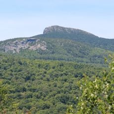
Mount Ellen, Mountain summit in Warren, Vermont

Description

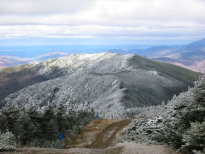
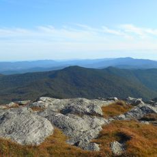
Mount Ellen rises to 1,245 meters (4,083 feet) in the Green Mountains and features forested slopes with trails connecting Lincoln Gap and Appalachian Gap. Multiple access routes lead to the summit, with the Jerusalem Trail from Starksboro offering a direct approach.

History

The name comes from either a character in Joseph Battell's 1903 novel or from Ellen Douglas in Sir Walter Scott's 1810 poem. The naming reflects literary influences that shaped mountain names throughout Vermont.

Culture

The Long Trail runs across the summit and connects Mount Ellen to a hiking network that links multiple peaks throughout the region.

Practical

The best time for hiking is during warmer months when trails are easily walkable and views from the summit are optimal. Plan extra time since sections are steep and sturdy footwear is essential.

Did you know?

A Cessna airplane crashed near the slopes in 1973, with the pilot surviving after hitting trees in cloudy conditions. The wreckage and survival story remain a quiet reminder of aviation hazards in this mountainous region.

Location
GPS coordinates
44.16013,-72.92887
Latest update
December 10, 2025 16:23

AroundUs brings together thousands of curated places, local tips, and hidden gems, enriched daily by 60,000 contributors worldwide. Discover all places nearby (Warren).

Around this place
Camel's Hump
United States of America

Camel's Hump

18.1 km
Mount Abraham
United States of America

Mount Abraham

4.5 km
Buels Gore
United States of America

Buels Gore

5.6 km
United States of America

Breadloaf Wilderness

16 km
Great Eddy Covered Bridge
United States of America

Great Eddy Covered Bridge

9 km
United States of America

Lincoln Peak

3.7 km
Warren Covered Bridge
United States of America

Warren Covered Bridge

7.9 km
Pine Brook Covered Bridge
United States of America

Pine Brook Covered Bridge

12.1 km
Camels Hump State Forest
United States of America

Camels Hump State Forest

6.4 km
Knoll Farm
United States of America

Knoll Farm

7.6 km
Lampson School
United States of America

Lampson School

16.3 km
Joslin Farm
United States of America

Joslin Farm

9.5 km
South Starksboro Friends Meeting House and Cemetery
United States of America

South Starksboro Friends Meeting House and Cemetery

6.9 km
Warren Village Historic District
United States of America

Warren Village Historic District

7.8 km
Union Church
United States of America

Union Church

16.3 km
Mad River Valley Rural Historic District
United States of America

Mad River Valley Rural Historic District

12.9 km
Huntington Lower Village Church
United States of America

Huntington Lower Village Church

19.1 km
Starksboro Village Meeting House
United States of America

Starksboro Village Meeting House

12.6 km
Hoag Gristmill and Knight House Complex
United States of America

Hoag Gristmill and Knight House Complex

14.5 km
Bristol Downtown Historic District
United States of America

Bristol Downtown Historic District

12.3 km
Bottum Farm
United States of America

Bottum Farm

18.4 km
Remington-Williamson Farm
United States of America

Remington-Williamson Farm

15.9 km
Waitsfield Village Historic District
United States of America

Waitsfield Village Historic District

9.1 km
Monkton Town Hall
United States of America

Monkton Town Hall

18.8 km
Waitsfield Common Historic District
United States of America

Waitsfield Common Historic District

11 km
Jones-Pestle Farmstead
United States of America

Jones-Pestle Farmstead

9.2 km
Moss Glen Falls
United States of America

Moss Glen Falls

17 km
Monkton Borough Baptist Church
United States of America

Monkton Borough Baptist Church

18.4 km
Show the full map
« Mount Ellen - Mountain summit in Warren, Vermont » is provided by Around Us (aroundus.com). Images and texts are derived from Wikimedia project under a Creative Commons license. You are allowed to copy, distribute, and modify copies of this page, under the conditions set by the license, as long as this note is clearly visible.

Discover hidden gems everywhere you go!

From secret cafés to breathtaking viewpoints, skip the crowded tourist spots and find places that match your style. Our app makes it easy with voice search, smart filtering, route optimization, and insider tips from travelers worldwide. Download now for the complete mobile experience.

Around Us App Screenshot

A unique approach to discovering new places

Le Figaro

All the places worth exploring

France Info

A tailor-made excursion in just a few clicks

20 Minutes

Around Us
Travel Guide & Maps
Download

Send to your phone

QR Code
1

Open the camera app on your mobile.

2

Point at the QR code with your camera. A notification will appear.

3

Tap the notification to open the link.