Moss Glen Falls

Log in to your account

AroundUs is a community-driven map of interesting places, built by curious explorers like you. It grows with every review, story, and photo you share.
Connect to save your favorite spots, contribute locations, and create personalized routes.
By continuing, you accept our Terms and Conditions and our Privacy Policy
Add to collection
Map
Suggest a change
Share

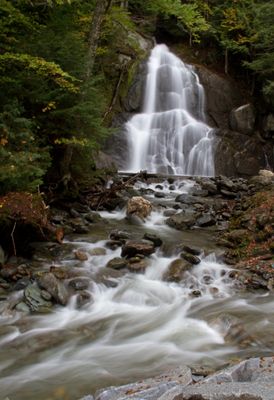
Moss Glen Falls, Waterfall in Granville, United States.

Moss Glen Falls is a waterfall with multiple cascades in the Granville Gulf Reservation along Vermont's Route 100. The water drops roughly 35 feet over a rocky face while splitting into two distinct channels as it descends.

The waterfall has served as a natural landmark along Vermont Route 100, which developed into the main north-south route through central Vermont. This road connection shaped how the region developed and was used for transportation and commerce.

The split water channels draw photographers seeking to capture flowing water against changing seasonal backgrounds. Visitors are drawn here especially during spring and autumn when natural light and colors enhance the scene.

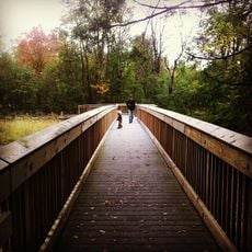
Access to the falls comes through a short wooden boardwalk from the parking area, making the visit straightforward for most visitors. The best visiting conditions occur between April and November when water flow and sight lines are most favorable.

Another waterfall with the same name exists in nearby Stowe, which sometimes confuses visitors seeking the right location. The two falls have different shapes and sit in completely separate areas, yet they often get mentioned in the same travel guides.

Location: Granville

Part of: Deer Hollow Brook

GPS coordinates: 44.01802,-72.85007

Latest update: December 6, 2025 19:01

Photos
Hidden places in Vermont: granite quarries, covered bridges, historic villages

Vermont hides historic places away from main roads, often forgotten by hurried travelers. Here you find granite quarries still working or long abandoned, small rural schools from the 1800s where children learned together, wooden covered bridges, and waterfalls flowing through thick forests. Trails...

Around this place
Mount Abraham
United States of America

Mount Abraham

13.3 km
Mount Ellen
United States of America

Mount Ellen

17 km
Robert Frost Farm
United States of America

Robert Frost Farm

13.7 km
Sunset Lake Floating Bridge
United States of America

Sunset Lake Floating Bridge

19.8 km
Breadloaf Wilderness
United States of America

Breadloaf Wilderness

5.3 km
Great Eddy Covered Bridge
United States of America

Great Eddy Covered Bridge

19.2 km
Lincoln Peak
United States of America

Lincoln Peak

13.6 km
Allis State Park
United States of America

Allis State Park

17.5 km
Warren Covered Bridge
United States of America

Warren Covered Bridge

10.4 km
Camels Hump State Forest
United States of America

Camels Hump State Forest

16.7 km
Knoll Farm
United States of America

Knoll Farm

19.5 km
Stony Brook Covered Bridge
United States of America

Stony Brook Covered Bridge

17.2 km
Chandler Music Hall
United States of America

Chandler Music Hall

18 km
Middlebury Gorge Concrete Arch Bridge
United States of America

Middlebury Gorge Concrete Arch Bridge

19.7 km
Mari-Castle
United States of America

Mari-Castle

18.4 km
Joslin Farm
United States of America

Joslin Farm

17.1 km
Marvin Newton House
United States of America

Marvin Newton House

19.9 km
Kimball Public Library
United States of America

Kimball Public Library

18 km
Warren Village Historic District
United States of America

Warren Village Historic District

10.7 km
Brookfield Village Historic District
United States of America

Brookfield Village Historic District

20.1 km
Fenn Farm
United States of America

Fenn Farm

20.8 km
Ripton Community House
United States of America

Ripton Community House

15.7 km
Depot Square Historic District
United States of America

Depot Square Historic District

18.2 km
Old Red Mill
United States of America

Old Red Mill

19 km
Waitsfield Village Historic District
United States of America

Waitsfield Village Historic District

19.3 km
Waitsfield Common Historic District
United States of America

Waitsfield Common Historic District

19.4 km
Jones-Pestle Farmstead
United States of America

Jones-Pestle Farmstead

18.9 km
Robert Frost Interpretive Area
United States of America

Robert Frost Interpretive Area

14.5 km
Show the full map
Reviews

Visited this place? Tap the stars to rate it and share your experience / photos with the community! Try now! You can cancel it anytime.

« Moss Glen Falls - Waterfall in Granville, United States » is provided by Around Us (aroundus.com). Images and texts are derived from Wikimedia project under a Creative Commons license. You are allowed to copy, distribute, and modify copies of this page, under the conditions set by the license, as long as this note is clearly visible.

Discover hidden gems everywhere you go!

From secret cafés to breathtaking viewpoints, skip the crowded tourist spots and find places that match your style. Our app makes it easy with voice search, smart filtering, route optimization, and insider tips from travelers worldwide. Download now for the complete mobile experience.

Around Us App Screenshot

A unique approach to discovering new places

Le Figaro

All the places worth exploring

France Info

A tailor-made excursion in just a few clicks

20 Minutes