Enable Location

We need your location to show you interesting places around you

Discover nearby places

Find interesting locations and hidden gems around you

Precise directions

Get accurate directions and distances to places

Your location is never shared with other users. It's only used when you tap the location button.

Log in to your account

Start exploring — it's free

Trusted by 62,170 travelers worldwide

Continue with Google
Continue with Apple
or

We will send you a code to connect

By continuing, you accept our Terms and Conditions and our Privacy Policy

Check your inbox

We've sent a pincode in your inbox. Please enter the code below.

Vermilion River Observatory

Vermilion River Observatory, Radio astronomy research facility in Danville, Illinois, United States

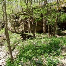
The Vermilion River Observatory was a radio astronomy research facility in Danville that used a large parabolic telescope built into a natural ravine. The structure stretched roughly 600 feet long and was covered with asphalt and wire mesh to collect signals from space.

The University of Illinois built this facility in 1959 under Professor George Swenson with support from the Office of Naval Research. The observatory operated for about 25 years before closing in 1984.

The facility attracted astronomers working to understand our galaxy's structure and cosmic phenomena through radio signals. Researchers here made discoveries that shaped how we view the universe today.

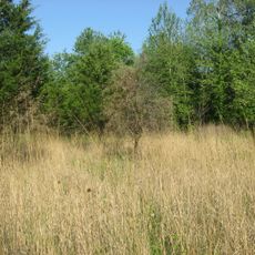
The site sits in a natural ravine outside Danville and is not easy to reach, as the facility is no longer active. Visitors should know the structure is heavily overgrown and located in a quiet, remote area.

Engineers cleverly used the natural ravine's slope to reduce construction costs and fit the telescope directly into the landscape. This resourceful approach allowed them to build a large instrument without expensive additional structures.

The community of curious travelers

AroundUs brings together thousands of curated places, local tips, and hidden gems, enriched daily by 60,000 contributors worldwide.

Start exploring
Location
Inception
1959
Official opening
1959
GPS coordinates
40.06111,-87.56111
Latest update
December 12, 2025 17:48
Around this place
Kickapoo State Recreation Area
United States of America

Kickapoo State Recreation Area

16.1 km
Portland Arch Nature Preserve
United States of America

Portland Arch Nature Preserve

26 km
Danville National Cemetery
United States of America

Danville National Cemetery

7.5 km
Fischer Theater
United States of America

Fischer Theater

9.5 km
Kennekuk Cove County Park
United States of America

Kennekuk Cove County Park

21.4 km
Fountain County Courthouse
United States of America

Fountain County Courthouse

16.3 km
Carnegie Library of Covington
United States of America

Carnegie Library of Covington

16.7 km
Danville Public Library
United States of America

Danville Public Library

9.6 km
Paris Carnegie Public Library
United States of America

Paris Carnegie Public Library

23.2 km
Mill Creek Covered Bridge
United States of America

Mill Creek Covered Bridge

24.1 km
Bowsher Ford Covered Bridge
United States of America

Bowsher Ford Covered Bridge

23.1 km
Asher Morton Farmstead
United States of America

Asher Morton Farmstead

23.2 km
Stone Arch Bridge
United States of America

Stone Arch Bridge

8.5 km
Danville Branch, National Home for Disabled Volunteer Soldiers Historic District
United States of America

Danville Branch, National Home for Disabled Volunteer Soldiers Historic District

7.4 km
Fithian House
United States of America

Fithian House

9.8 km
United States of America

First National Bank Building

9.2 km
Collins Archeological District
United States of America

Collins Archeological District

22.5 km
Holland Apartments
United States of America

Holland Apartments

9.7 km
Adams Building
United States of America

Adams Building

9.4 km
W. H. York Round Barn
United States of America

W. H. York Round Barn

19.2 km
Williams Chapel
United States of America

Williams Chapel

19.7 km
Eugene Covered Bridge
United States of America

Eugene Covered Bridge

12.7 km
Vermillion County Courthouse
United States of America

Vermillion County Courthouse

23.5 km
Fountain County Clerk's Building
United States of America

Fountain County Clerk's Building

16.4 km
Newport Covered Bridge
United States of America

Newport Covered Bridge

21.8 km
Covington Courthouse Square Historic District
United States of America

Covington Courthouse Square Historic District

16.3 km
Covington Residential Historic District
United States of America

Covington Residential Historic District

16.6 km
William C.B. Sewell House
United States of America

William C.B. Sewell House

16.6 km
Show the full map
« Vermilion River Observatory - Radio astronomy research facility in Danville, Illinois, United States » is provided by Around Us (aroundus.com). Images and texts are derived from Wikimedia project under a Creative Commons license. You are allowed to copy, distribute, and modify copies of this page, under the conditions set by the license, as long as this note is clearly visible.

Discover hidden gems everywhere you go!

From secret cafés to breathtaking viewpoints, skip the crowded tourist spots and find places that match your style. Our app makes it easy with voice search, smart filtering, route optimization, and insider tips from travelers worldwide. Download now for the complete mobile experience.

Around Us App Screenshot

A unique approach to discovering new places

Le Figaro

All the places worth exploring

France Info

A tailor-made excursion in just a few clicks

20 Minutes

Around Us
Travel Guide & Maps
Download

Send to your phone

QR Code
1

Open the camera app on your mobile.

2

Point at the QR code with your camera. A notification will appear.

3

Tap the notification to open the link.