Enable Location

We need your location to show you interesting places around you

Discover nearby places

Find interesting locations and hidden gems around you

Precise directions

Get accurate directions and distances to places

Your location is never shared with other users. It's only used when you tap the location button.

Log in to your account

Start exploring — it's free

Trusted by 61,585 travelers worldwide

Continue with Google
Continue with Apple
or

We will send you a code to connect

By continuing, you accept our Terms and Conditions and our Privacy Policy

Check your inbox

We've sent a pincode in your inbox. Please enter the code below.

Carite State Forest

Carite State Forest, State forest in southeastern Puerto Rico.

Description

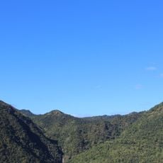
Carite State Forest covers 6,500 acres across five municipalities in the Sierra de Cayey mountain range, with subtropical moist forests and low mountain zones. The terrain contains multiple watersheds and streams that feed into the Loíza, Patillas, and La Plata river systems.

History

Protection of this forest was established in 1935 through an official proclamation to prevent erosion of the river basins. This action was taken to preserve the natural water sources that serve the surrounding communities.

Culture

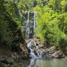
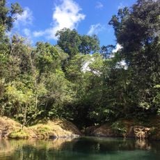
Local families come here to spend time outdoors and learn about the plants and animals that live in this region. The trails and natural pools are places where people connect with the forest in their everyday lives.

Practical

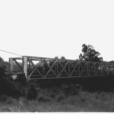
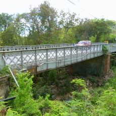
You can reach the forest by driving on Road 184 in Cayey. The Charco Azul Trail is the main path and takes you to natural swimming areas within the forest.

Did you know?

This forest is home to over 200 tree species, including the Puerto Rican magnolia and native raintrees. You might spot the Puerto Rican broad-winged hawk soaring through the canopy, a bird of prey that hunts in this region.

Location
GPS coordinates
18.10583,-66.05167
Latest update
December 12, 2025 17:42

AroundUs brings together thousands of curated places, local tips, and hidden gems, enriched daily by 60,000 contributors worldwide. Discover all places nearby (Puerto Rico).

Around this place
Monumento al Jíbaro Puertorriqueño
United States of America

Monumento al Jíbaro Puertorriqueño

17.9 km
Casa Cautiño
United States of America

Casa Cautiño

14.9 km
Punta Tuna Light
United States of America

Punta Tuna Light

21.9 km
Casa Roig Museum
United States of America

Casa Roig Museum

24.4 km
Arenas Bridge
United States of America

Arenas Bridge

9.7 km
United States of America

La Robleda Natural Protected Area

10.7 km
Punta de las Figuras Light
United States of America

Punta de las Figuras Light

16.8 km
William Miranda Marín Botanical and Cultural Garden
United States of America

William Miranda Marín Botanical and Cultural Garden

14 km
Cayey Bridge
United States of America

Cayey Bridge

13.3 km
Planadas-Yeyesa Nature Reserve
United States of America

Planadas-Yeyesa Nature Reserve

17.8 km
José Ignacio Quintón Center for Creole Music
United States of America

José Ignacio Quintón Center for Creole Music

14.5 km
La Liendre Bridge
United States of America

La Liendre Bridge

9.1 km
Caguas Museum of Art
United States of America

Caguas Museum of Art

14.5 km
Aguayo Aldea Vocational High School
United States of America

Aguayo Aldea Vocational High School

14.3 km
Caguas Museum of Folk Arts
United States of America

Caguas Museum of Folk Arts

14.4 km
Puente No. 6
United States of America

Puente No. 6

20.1 km
Caguas Museum of History
United States of America

Caguas Museum of History

14.5 km
Caguas Museum of Tobacco
United States of America

Caguas Museum of Tobacco

14.4 km
Eleuterio Derkes Grammar School
United States of America

Eleuterio Derkes Grammar School

15.2 km
Río Hondo Bridge
United States of America

Río Hondo Bridge

23.3 km
Hacienda Los Maldonado
Puerto Rico

Hacienda Los Maldonado

20.5 km
Cascada Charco Prieto
Puerto Rico

Cascada Charco Prieto

24.2 km
Charco Azul
Puerto Rico

Charco Azul

2.6 km
La Casa del Cuento y de la Historia Cayeyana Ramón "Moncho" Gómez
United States of America

La Casa del Cuento y de la Historia Cayeyana Ramón "Moncho" Gómez

12 km
La Casa de la Navidad
Puerto Rico

La Casa de la Navidad

15.3 km
Casa y Museo del Poeta Luis Palés Matos
Puerto Rico

Casa y Museo del Poeta Luis Palés Matos

15 km
Maunabo City Hall
United States of America

Maunabo City Hall

19.5 km
Lago Patillas
United States of America

Lago Patillas

9.6 km
Show the full map
« Carite State Forest - State forest in southeastern Puerto Rico » is provided by Around Us (aroundus.com). Images and texts are derived from Wikimedia project under a Creative Commons license. You are allowed to copy, distribute, and modify copies of this page, under the conditions set by the license, as long as this note is clearly visible.

Discover hidden gems everywhere you go!

From secret cafés to breathtaking viewpoints, skip the crowded tourist spots and find places that match your style. Our app makes it easy with voice search, smart filtering, route optimization, and insider tips from travelers worldwide. Download now for the complete mobile experience.

Around Us App Screenshot

A unique approach to discovering new places

Le Figaro

All the places worth exploring

France Info

A tailor-made excursion in just a few clicks

20 Minutes

Around Us
Travel Guide & Maps
Download

Send to your phone

QR Code
1

Open the camera app on your mobile.

2

Point at the QR code with your camera. A notification will appear.

3

Tap the notification to open the link.