Enable Location

We need your location to show you interesting places around you

Discover nearby places

Find interesting locations and hidden gems around you

Precise directions

Get accurate directions and distances to places

Your location is never shared with other users. It's only used when you tap the location button.

Arenas Bridge

Log in to your account

Start exploring — it's free

Trusted by 63,226 travelers worldwide

Continue with Google
Continue with Apple
or

We will send you a code to connect

By continuing, you accept our Terms and Conditions and our Privacy Policy

Check your inbox

We've sent a pincode in your inbox. Please enter the code below.

Discussion Reviews 1 Photos
1.5k Popularity

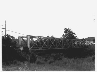
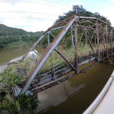
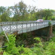
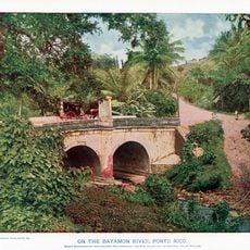
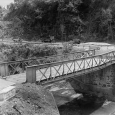
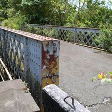
Arenas Bridge, Truss bridge between Cayey and Cidra, Puerto Rico

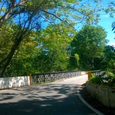
Arenas Bridge is a steel structure spanning Rio de la Plata and connecting Cayey and Cidra through Puerto Rico Highway 735. The crossing features the latticed framework typical of truss bridges from the late 1800s, with riveted steel beams forming its supporting system.

The bridge was built in 1894 during Spanish colonial rule by a Belgian engineering firm and was the longest crossing structure on the island at that time. This project marked a turning point in how the island approached its infrastructure development.

The bridge connects two neighboring municipalities and has become part of the local landscape as an engineering landmark from the colonial era. It represents the kind of infrastructure investment that shaped how communities in the island developed and interacted with one another.

The bridge carries regular vehicle traffic as part of the regional road network, so visitors should be mindful of passing cars. Finding a safe viewpoint from nearby areas will allow for better observation of the structure without interfering with traffic flow.

The steel framework was entirely fabricated overseas in Belgium because Puerto Rico had no metal manufacturing industry in the early 1890s. This made it an example of the island's reliance on foreign technical resources during this period of development.

The community of curious travelers

AroundUs brings together thousands of curated places, local tips, and hidden gems, enriched daily by 60,000 contributors worldwide.

Start exploring
Location
Location
Inception
1894
Made from material
steel
GPS coordinates
18.13433,-66.13812
Latest update
December 14, 2025 14:22
Around this place
Monumento al Jíbaro Puertorriqueño
United States of America

Monumento al Jíbaro Puertorriqueño

10.9 km
United States of America

Carite State Forest

9.7 km
Casa Cautiño
United States of America

Casa Cautiño

16.7 km
United States of America

La Robleda Natural Protected Area

5.9 km
Old Plata Bridge
United States of America

Old Plata Bridge

20.6 km
William Miranda Marín Botanical and Cultural Garden
United States of America

William Miranda Marín Botanical and Cultural Garden

15 km
Cayey Bridge
United States of America

Cayey Bridge

14.9 km
Planadas-Yeyesa Nature Reserve
United States of America

Planadas-Yeyesa Nature Reserve

10.1 km
José Ignacio Quintón Center for Creole Music
United States of America

José Ignacio Quintón Center for Creole Music

15.7 km
La Liendre Bridge
United States of America

La Liendre Bridge

684 m
Puente de las Calabazas
United States of America

Puente de las Calabazas

19.2 km
Caguas Museum of Art
United States of America

Caguas Museum of Art

15.6 km
Aguayo Aldea Vocational High School
United States of America

Aguayo Aldea Vocational High School

15.8 km
Caguas Museum of Folk Arts
United States of America

Caguas Museum of Folk Arts

15.5 km
Puente No. 6
United States of America

Puente No. 6

19.6 km
Casa Natal de Luis Muñoz Rivera
United States of America

Casa Natal de Luis Muñoz Rivera

19 km
Caguas Museum of History
United States of America

Caguas Museum of History

15.5 km
Caguas Museum of Tobacco
United States of America

Caguas Museum of Tobacco

15.5 km
Eleuterio Derkes Grammar School
United States of America

Eleuterio Derkes Grammar School

17.2 km
Río Hondo Bridge
United States of America

Río Hondo Bridge

13.8 km
Hacienda Los Maldonado
Puerto Rico

Hacienda Los Maldonado

13.7 km
Cascada Charco Prieto
Puerto Rico

Cascada Charco Prieto

17.3 km
Charco Azul
Puerto Rico

Charco Azul

12.2 km
La Casa del Cuento y de la Historia Cayeyana Ramón "Moncho" Gómez
United States of America

La Casa del Cuento y de la Historia Cayeyana Ramón "Moncho" Gómez

3.7 km
La Casa de la Navidad
Puerto Rico

La Casa de la Navidad

17.5 km
Casa y Museo del Poeta Luis Palés Matos
Puerto Rico

Casa y Museo del Poeta Luis Palés Matos

17 km
Carretera Central historic district
United States of America

Carretera Central historic district

16.4 km
Lago Patillas
United States of America

Lago Patillas

17.4 km
Show the full map
Reviews
Share your experience

No review yet

Discussions
Start a discussion...

No discussion yet

« Arenas Bridge - Truss bridge between Cayey and Cidra, Puerto Rico » is provided by Around Us (aroundus.com). Images and texts are derived from Wikimedia project under a Creative Commons license. You are allowed to copy, distribute, and modify copies of this page, under the conditions set by the license, as long as this note is clearly visible.

Discover hidden gems everywhere you go!

From secret cafés to breathtaking viewpoints, skip the crowded tourist spots and find places that match your style. Our app makes it easy with voice search, smart filtering, route optimization, and insider tips from travelers worldwide. Download now for the complete mobile experience.

Around Us App Screenshot

A unique approach to discovering new places

Le Figaro

All the places worth exploring

France Info

A tailor-made excursion in just a few clicks

20 Minutes

Around Us
Travel Guide & Maps
Download

Send to your phone

QR Code
1

Open the camera app on your mobile.

2

Point at the QR code with your camera. A notification will appear.

3

Tap the notification to open the link.