Enable Location

We need your location to show you interesting places around you

Discover nearby places

Find interesting locations and hidden gems around you

Precise directions

Get accurate directions and distances to places

Your location is never shared with other users. It's only used when you tap the location button.

Log in to your account

Start exploring — it's free

Trusted by 62,120 travelers worldwide

Continue with Google
Continue with Apple
or

We will send you a code to connect

By continuing, you accept our Terms and Conditions and our Privacy Policy

Check your inbox

We've sent a pincode in your inbox. Please enter the code below.

Martin's Point Bridge

Martin's Point Bridge, Road bridge in Portland, United States

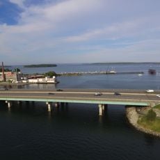
Martin's Point Bridge is a road bridge that crosses the Presumpscot River, connecting Falmouth Foreside to the East Deering neighborhood of Portland. The structure carries U.S. Route 1 and forms part of the East Coast Greenway system, offering bicycle lanes in both directions and a pedestrian walkway on its eastern side.

The original bridge was built in 1828 as a toll structure but was destroyed by ice in 1861. After this event, it was rebuilt and modernized to handle increasing traffic demands.

The bridge connects two communities and forms part of the daily commute for local residents, serving as an important link in the area's transportation network.

The crossing is open to vehicles, cyclists, and pedestrians and remains accessible under normal conditions. During maintenance work or winter weather, visitors should expect potential delays and explore alternative routes.

After removal of the Smelt Hill Dam in 2002, the Presumpscot Falls became visible, transforming the river's appearance after several centuries. These waterfalls now create a striking natural contrast to the bridge's modern infrastructure.

The community of curious travelers

AroundUs brings together thousands of curated places, local tips, and hidden gems, enriched daily by 60,000 contributors worldwide.

Start exploring
GPS coordinates
43.69167,-70.24489
Latest update
December 14, 2025 18:46
Around this place
Fort Gorges
United States of America

Fort Gorges

3.7 km
Portland High School
United States of America

Portland High School

3.8 km
Portland Observatory
United States of America

Portland Observatory

3 km
Maine Narrow Gauge Railroad Museum
United States of America

Maine Narrow Gauge Railroad Museum

3.2 km
Eastern Promenade
United States of America

Eastern Promenade

2.2 km
Abyssinian Meeting House
United States of America

Abyssinian Meeting House

3.3 km
Kotzschmar Memorial Organ
United States of America

Kotzschmar Memorial Organ

3.7 km
Eastern Cemetery
United States of America

Eastern Cemetery

3.3 km
Portland City Hall
United States of America

Portland City Hall

3.7 km
Tukey's Bridge
United States of America

Tukey's Bridge

2 km
Wendameen
United States of America

Wendameen

3.8 km
Payson Park
United States of America

Payson Park

2.1 km
Ocean Gateway International Marine Passenger Terminal
United States of America

Ocean Gateway International Marine Passenger Terminal

3.6 km
Etz Chaim Synagogue
United States of America

Etz Chaim Synagogue

3.3 km
St. Lawrence Arts Center
United States of America

St. Lawrence Arts Center

2.8 km
Chestnut Street Methodist Church
United States of America

Chestnut Street Methodist Church

3.7 km
Masonic Temple
United States of America

Masonic Temple

3.8 km
Baxter Summer Home
United States of America

Baxter Summer Home

1 km
Portland, Maine Marine Hospital
United States of America

Portland, Maine Marine Hospital

427 m
John B. Russwurm House
United States of America

John B. Russwurm House

3.2 km
Mayo Street Arts
United States of America

Mayo Street Arts

3.3 km
Schlotterbeck and Foss Building
United States of America

Schlotterbeck and Foss Building

3.8 km
Payson House at Thornhurst
United States of America

Payson House at Thornhurst

3.4 km
East End Beach
United States of America

East End Beach

2.6 km
Thomas Skelton House
United States of America

Thomas Skelton House

1.9 km
Sparrow House
United States of America

Sparrow House

3.9 km
Plummer-Motz School
United States of America

Plummer-Motz School

3.6 km
Pullen Fountain
United States of America

Pullen Fountain

3.7 km
Show the full map
« Martin's Point Bridge - Road bridge in Portland, United States » is provided by Around Us (aroundus.com). Images and texts are derived from Wikimedia project under a Creative Commons license. You are allowed to copy, distribute, and modify copies of this page, under the conditions set by the license, as long as this note is clearly visible.

Discover hidden gems everywhere you go!

From secret cafés to breathtaking viewpoints, skip the crowded tourist spots and find places that match your style. Our app makes it easy with voice search, smart filtering, route optimization, and insider tips from travelers worldwide. Download now for the complete mobile experience.

Around Us App Screenshot

A unique approach to discovering new places

Le Figaro

All the places worth exploring

France Info

A tailor-made excursion in just a few clicks

20 Minutes

Around Us
Travel Guide & Maps
Download

Send to your phone

QR Code
1

Open the camera app on your mobile.

2

Point at the QR code with your camera. A notification will appear.

3

Tap the notification to open the link.