Enable Location

We need your location to show you interesting places around you

Discover nearby places

Find interesting locations and hidden gems around you

Precise directions

Get accurate directions and distances to places

Your location is never shared with other users. It's only used when you tap the location button.

Lyme–East Thetford Bridge

Log in to your account

Start exploring — it's free

Trusted by 63,117 travelers worldwide

Continue with Google
Continue with Apple
or

We will send you a code to connect

By continuing, you accept our Terms and Conditions and our Privacy Policy

Check your inbox

We've sent a pincode in your inbox. Please enter the code below.

Lyme–East Thetford Bridge
Discussion Reviews 1 Photos
1.7k Popularity

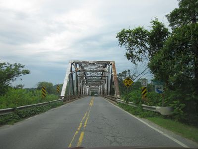
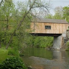
Lyme–East Thetford Bridge, Road bridge across Connecticut River between Lyme, New Hampshire and East Thetford, Vermont, United States.

The Lyme-East Thetford Bridge is a steel structure spanning the Connecticut River between New Hampshire and Vermont using a Parker truss design. Two main spans support the roadway with vertical bracing members anchored to substantial supports on each bank.

The current structure was built in 1937 using Works Progress Administration funding after its predecessor from the 1890s was destroyed by flooding in 1936. The new design incorporated advances in bridge engineering methods of that era.

The bridge serves as a physical connection point between New Hampshire and Vermont communities, facilitating regular interactions between residents of both states.

The structure is regularly inspected and maintained to meet current safety standards for ongoing vehicle traffic. Visitors should note this is an active road connection with normal traffic flow.

This bridge holds the distinction of being the longest two-span Parker truss structure in New Hampshire and is one of only five similar designs crossing the Connecticut River. The steel framework with its distinctive latticed pattern offers a direct look at early-20th-century bridge engineering techniques.

The community of curious travelers

AroundUs brings together thousands of curated places, local tips, and hidden gems, enriched daily by 60,000 contributors worldwide.

Start exploring
GPS coordinates
43.81214,-72.18310
Latest update
December 14, 2025 13:07
Around this place
Baker-Berry Library
United States of America

Baker-Berry Library

14.6 km
Vermontasaurus
United States of America

Vermontasaurus

9.8 km
Smarts Mountain
United States of America

Smarts Mountain

12.2 km
Ompompanoosuc River
United States of America

Ompompanoosuc River

7.7 km
Gile Mountain
United States of America

Gile Mountain

13.8 km
Camp Billings
United States of America

Camp Billings

9.6 km
Morey Memorial Bridge
United States of America

Morey Memorial Bridge

11.1 km
Shattuck Observatory
United States of America

Shattuck Observatory

14.5 km
Lanakila Camp
United States of America

Lanakila Camp

14.3 km
Scully-Fahey Field
United States of America

Scully-Fahey Field

14.6 km
Aloha Hive Camp
United States of America

Aloha Hive Camp

9.4 km
Thetford Hill State Park
United States of America

Thetford Hill State Park

4 km
Root School
United States of America

Root School

9.8 km
Aloha Horizons Camp
United States of America

Aloha Horizons Camp

9.6 km
Hanover Town Library
United States of America

Hanover Town Library

13.4 km
Union Village Covered Bridge
United States of America

Union Village Covered Bridge

6.3 km
Orford Street Historic District
United States of America

Orford Street Historic District

11 km
Great Hollow Road Stone Arch Bridge
United States of America

Great Hollow Road Stone Arch Bridge

14.5 km
Post Mills Church
United States of America

Post Mills Church

10 km
Thetford Center Covered Bridge
United States of America

Thetford Center Covered Bridge

6.1 km
Peabody Library
United States of America

Peabody Library

10.3 km
Fairlee Town Hall
United States of America

Fairlee Town Hall

11.2 km
Thetford Center Historic District
United States of America

Thetford Center Historic District

5.7 km
Thetford Hill Historic District
United States of America

Thetford Hill Historic District

3.7 km
Asa May House
United States of America

Asa May House

12.8 km
Lyme Common Historic District
United States of America

Lyme Common Historic District

2.1 km
Moses Kent House
United States of America

Moses Kent House

6.7 km
Orford-Fairlee Covered Bridge
United States of America

Orford-Fairlee Covered Bridge

11.1 km
Show the full map
Reviews
Share your experience

No review yet

Discussions
Start a discussion...

No discussion yet

« Lyme–East Thetford Bridge - Road bridge across Connecticut River between Lyme, New Hampshire and East Thetford, Vermont, United States » is provided by Around Us (aroundus.com). Images and texts are derived from Wikimedia project under a Creative Commons license. You are allowed to copy, distribute, and modify copies of this page, under the conditions set by the license, as long as this note is clearly visible.

Discover hidden gems everywhere you go!

From secret cafés to breathtaking viewpoints, skip the crowded tourist spots and find places that match your style. Our app makes it easy with voice search, smart filtering, route optimization, and insider tips from travelers worldwide. Download now for the complete mobile experience.

Around Us App Screenshot

A unique approach to discovering new places

Le Figaro

All the places worth exploring

France Info

A tailor-made excursion in just a few clicks

20 Minutes

Around Us
Travel Guide & Maps
Download

Send to your phone

QR Code
1

Open the camera app on your mobile.

2

Point at the QR code with your camera. A notification will appear.

3

Tap the notification to open the link.