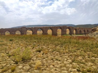
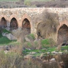
Puente de la Mesta, Medieval bridge near Villarta de los Montes, Spain
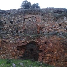
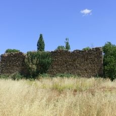
The Puente de la Mesta crosses the Guadiana River with 27 pointed arches extending 225 meters, combining stone and brick in its construction. The structure sits low to the water and displays the robust building methods of medieval times.
Built in the 14th century, the bridge enabled livestock herds to travel through the Cañada Real Segoviana. It connected Castilian territories with southern regions and played a central role in the trade routes of its era.
The bridge served as a crucial crossing for the Mesta, a medieval shepherding organization that moved livestock across Spain. Its name still reflects this historical function and the routes these herders traveled regularly.
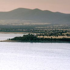
The structure becomes visible only when water levels drop in the Cíjara Reservoir. Visitors should check reservoir conditions before visiting, as water levels determine how much of the bridge can be seen.
In 2022, the bridge was added to the Red List of Heritage due to its condition deteriorating under the reservoir waters. This designation highlights how this medieval structure has become submerged and endangered by modern water management.
Location: Villarta de los Montes
GPS coordinates: 39.23570,-4.75910
Latest update: December 14, 2025 18:00
Cabañeros National Park
29.5 km
Cíjara Reservoir
15.4 km
García Sola Reservoir
38.3 km
Castle of Herrera del Duque
25.1 km
Torre de Abraham Reservoir
46 km
Cascada del Chorro
36.1 km
Cíjara reserve
26.3 km
Castle of Malamoneda
47 km
Yacimiento arqueológico de Malamoneda
47.4 km
Chorrera de Horcajo
18.7 km
Cerro de la Barca
34.2 km
Iglesia de San Juan Bautista, Herrera del Duque
26.1 km
Plaza de toros
26.1 km
Ermita de Consolación (Herrera del Duque)
28.9 km
Tower of Malamoneda
47.4 km
Iglesia de San Sebastián, Los Navalucillos
49 km
Iglesia de San Cristóbal (Castilblanco)
29.2 km
Puente medieval de Herrera del Duque
25.3 km
Iglesia de Nuestra Señora de la Consolación, Alcoba de los Montes
24.5 km
Agencia de Lectura Pública Municipal de Sancti-Spíritus - Espiritu Santo
48.2 km
Biblioteca Pública Municipal de Agudo
29.7 km
Granero de Saceruela
34.7 km
Bullring of Agudo
29.9 km
Church of the Chair of Saint Peter in Antioch
46.9 km
Silo de Alía
46.1 km
Granero de Agudo
29.6 km
Church of San Benito Abad, Agudo
29.8 km
Church of Saint Catherine of Alexandria, Alía
46.1 kmVisited this place? Tap the stars to rate it and share your experience / photos with the community! Try now! You can cancel it anytime.
Discover hidden gems everywhere you go!
From secret cafés to breathtaking viewpoints, skip the crowded tourist spots and find places that match your style. Our app makes it easy with voice search, smart filtering, route optimization, and insider tips from travelers worldwide. Download now for the complete mobile experience.
A unique approach to discovering new places❞
— Le Figaro
All the places worth exploring❞
— France Info
A tailor-made excursion in just a few clicks❞
— 20 Minutes