Enable Location

We need your location to show you interesting places around you

Discover nearby places

Find interesting locations and hidden gems around you

Precise directions

Get accurate directions and distances to places

Your location is never shared with other users. It's only used when you tap the location button.

The Kench, Hayling Island

Log in to your account

Start exploring — it's free

Trusted by 61,993 travelers worldwide

Continue with Google
Continue with Apple
or

We will send you a code to connect

By continuing, you accept our Terms and Conditions and our Privacy Policy

Check your inbox

We've sent a pincode in your inbox. Please enter the code below.

The Kench, Hayling Island

The Kench, Hayling Island, Nature reserve in Hayling Island, United Kingdom

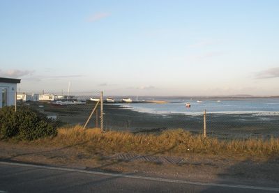
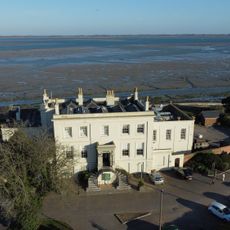
The Kench is a nature reserve on Hayling Island encompassing saltmarsh and mudflat habitats along the southern shore of Langstone Harbour. These wetland areas support numerous bird species and are crossed by pathways that allow visitors to explore the intertidal zone.

The location was rescued from planned marina development when Hampshire County Council acquired the land in the late 20th century. This protected the habitat from commercial expansion and allowed the natural systems to remain intact.

The reserve is woven into local conservation efforts along the Hampshire coast, where residents value it as a place to watch wildlife and connect with the natural environment. The sheltered location has long been important for people seeking quiet moments near the shore.

The reserve can be reached via Ferry Road, with pathways on the eastern side leading to observation points overlooking the harbour. Be prepared for muddy ground and check tide levels before visiting, as water levels can affect access to certain areas.

A collection of converted military vessels from the 1950s remains moored here as permanent houseboats. These repurposed boats tell the story of how people adapted to housing shortages by living on the water within this sheltered inlet.

The community of curious travelers

AroundUs brings together thousands of curated places, local tips, and hidden gems, enriched daily by 60,000 contributors worldwide.

Start exploring
GPS coordinates
50.79300,-1.02000
Latest update
December 14, 2025 18:06
Around this place
Royal Marines Museum
United Kingdom

Royal Marines Museum

2.6 km
Fort Cumberland
United Kingdom

Fort Cumberland

992 m
Funland
United Kingdom

Funland

2.6 km
Klondike Gold Mine
United Kingdom

Klondike Gold Mine

2.5 km
St Mary's Church, Hayling Island
United Kingdom

St Mary's Church, Hayling Island

3.1 km
Eastney Beam Engine House
United Kingdom

Eastney Beam Engine House

1.9 km
Station Theatre
United Kingdom

Station Theatre

1.8 km
Church of St Patrick
United Kingdom

Church of St Patrick

3.1 km
The Yomper
United Kingdom

The Yomper

2.6 km
Church of St James
United Kingdom

Church of St James

2.7 km
Milton Cemetery Chapel
United Kingdom

Milton Cemetery Chapel

2.9 km
Eastfield Hotel
United Kingdom

Eastfield Hotel

2.8 km
Beddow Library
United Kingdom

Beddow Library

2.8 km
Eastney Barracks, Lunsden Memorial  Eastney Barracks, Lunsden Memorial, At East End Of Former Parade Ground
United Kingdom

Eastney Barracks, Lunsden Memorial Eastney Barracks, Lunsden Memorial, At East End Of Former Parade Ground

2.4 km
Great Salterns House And Attached Walls
United Kingdom

Great Salterns House And Attached Walls

2.9 km
The Shades Public House
United Kingdom

The Shades Public House

2.2 km
St James Hospital And Attached Piers And Lamp Posts
United Kingdom

St James Hospital And Attached Piers And Lamp Posts

2.2 km
World War II Heavy Anti-aircraft gunsite (P2) at Sinah Common, 570m south east of Sinah Farm
United Kingdom

World War II Heavy Anti-aircraft gunsite (P2) at Sinah Common, 570m south east of Sinah Farm

882 m
Sea Lock And Basin
United Kingdom

Sea Lock And Basin

1.3 km
Gate Piers And Gates, Milton Cemetery
United Kingdom

Gate Piers And Gates, Milton Cemetery

2.9 km
Former Eastney House, Linking Archway And Railings  Teapot Row
United Kingdom

Former Eastney House, Linking Archway And Railings Teapot Row

2.8 km
Eastney Batteries
United Kingdom

Eastney Batteries

2.6 km
Eastney sewage pumping station
United Kingdom

Eastney sewage pumping station

1.9 km
35-53, Norfolk Crescent
United Kingdom

35-53, Norfolk Crescent

2.1 km
Former Officers Quarters, Fort Cumberland
United Kingdom

Former Officers Quarters, Fort Cumberland

964 m
Former Guard House, Fort Cumberland
United Kingdom

Former Guard House, Fort Cumberland

1 km
Lamp Columns On Promenade, South Side Of Eastney Esplanade
United Kingdom

Lamp Columns On Promenade, South Side Of Eastney Esplanade

2.4 km
Milton Cemetery War Memorial, Portsmouth
United Kingdom

Milton Cemetery War Memorial, Portsmouth

2.9 km
Show the full map
« The Kench, Hayling Island - Nature reserve in Hayling Island, United Kingdom » is provided by Around Us (aroundus.com). Images and texts are derived from Wikimedia project under a Creative Commons license. You are allowed to copy, distribute, and modify copies of this page, under the conditions set by the license, as long as this note is clearly visible.

Discover hidden gems everywhere you go!

From secret cafés to breathtaking viewpoints, skip the crowded tourist spots and find places that match your style. Our app makes it easy with voice search, smart filtering, route optimization, and insider tips from travelers worldwide. Download now for the complete mobile experience.

Around Us App Screenshot

A unique approach to discovering new places

Le Figaro

All the places worth exploring

France Info

A tailor-made excursion in just a few clicks

20 Minutes

Around Us
Travel Guide & Maps
Download

Send to your phone

QR Code
1

Open the camera app on your mobile.

2

Point at the QR code with your camera. A notification will appear.

3

Tap the notification to open the link.