Arnside Viaduct, Railway viaduct in Cumbria, England
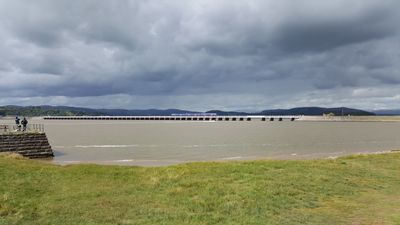
Arnside Viaduct is a railway viaduct spanning across the River Kent estuary and stretching across several hundred meters with numerous concrete piers supporting the tracks. The structure's massive pillars rise from the riverbed to carry the rails, engineered with modern materials to ensure durability across tidal conditions.
The original viaduct was built in 1857 and underwent complete reconstruction in 1915 to accommodate increased traffic during the First World War. The rebuild enabled better connections to the shipyards of Barrow, which were critical to the war effort.
The viaduct serves as a vital transport link within the Cumbrian Coast Line, connecting communities between Lancaster and Barrow-in-Furness daily. For local residents, the railway has become woven into everyday life, its passing trains a familiar rhythm of the landscape.
The viaduct is visible from the nearby road and offers good views across the estuary and surrounding landscape. Visitors should be aware that tidal patterns affect the riverbed below significantly, and the best views are at low tide when the banks are more exposed.
The viaduct pioneered the use of water jet technology for pile foundation work, a method applied for the first time globally on this type of structure. This innovative technique significantly accelerated construction and set new standards for similar engineering projects elsewhere.
The community of curious travelers
AroundUs brings together thousands of curated places, local tips, and hidden gems, enriched daily by 60,000 contributors worldwide.