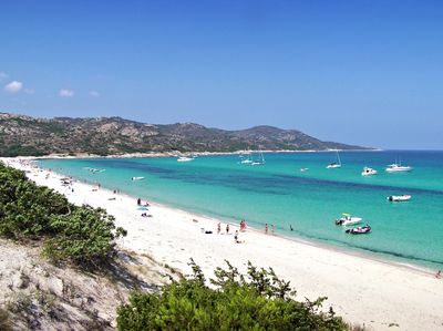
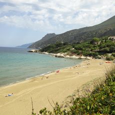
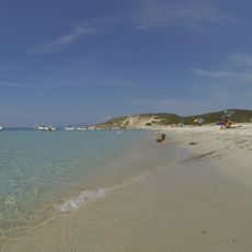
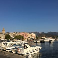
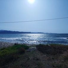
Saleccia beach, White sand beach in northern Corsica, France
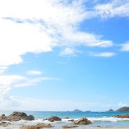
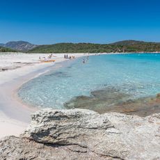
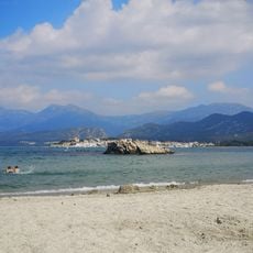
Saleccia is a beach in northern Corsica, France, stretching over 1200 meters (3900 feet). White sand forms dunes behind the turquoise water, while the mountains of Cap Corse rise in the background.
In 1943, the submarine Casabianca used this remote beach to deliver weapons to French resistance fighters. The bay offered a sheltered point for secret operations during the German occupation of Corsica.
The film The Longest Day from 1961 used this beach to shoot scenes of the Normandy landings. The location was chosen because it resembled northern French coasts.
A boat from Saint-Florent takes around 25 minutes and runs regularly during summer months. Alternatively, a long hiking trail through the Désert des Agriates or a rough track for off-road vehicles leads to the beach.
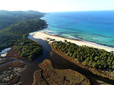
The beach has no fixed facilities like restaurants or sunshade rentals. Its location within the protected desert landscape of the Agriates preserves the original state of the coastline.
Location: Corsica
Length: 1,200 m
GPS coordinates: 42.72677,9.20550
Latest update: December 5, 2025 22:30
The French coastline stretches over more than 3,100 miles and features a notable variety of beaches. From Brittany's granite coasts to Mediterranean coves, including wide Atlantic stretches and Corsican bays with clear waters, each coastal area has its own character. This selection takes you away from crowded seaside resorts to beaches that have maintained their natural state. You will find the wild Piémanson beach in Camargue, accessible only via a dirt road and visited by pink flamingos, the discreet Nonnes beach on the Gironde estuary with its caves carved into the cliffs, or Notre-Dame beach on Porquerolles, considered one of the top spots in the Mediterranean. In Corsica, Saleccia requires an hour of walking or a boat trip to reach, while the Côte des Basques in Biarritz has attracted surfers since the 1950s. Some beaches demand effort to access, others are protected as nature reserves, but all offer a different experience from mass tourism.
Europe's most secluded beaches offer access to natural coastal environments that remain undeveloped due to their distance from major tourist centers. These locations span from the volcanic black sands of Iceland's southern shores to the pink-tinted beaches of southwestern Crete, formed from crushed seashells. Many require hiking through nature reserves or boat transfers to reach. Protected coastlines feature distinct geological characteristics: limestone cliffs eroded into natural arches along Portugal's Algarve, basalt columns rising from Norwegian fjords, and serpentine rock formations containing high magnesium content in Cornwall. The beaches exist within varied ecosystems, from Mediterranean scrubland surrounding Sicilian coves to Arctic conditions where granite mountains shelter narrow sand stretches in the Lofoten archipelago. These sites attract visitors seeking alternatives to developed resort areas. Access methods range from tidal passages through stone arches in Galicia, where water levels determine entry times, to unpaved tracks crossing the Desert of Agriates in Corsica. Several beaches change appearance based on natural forces: the Croatian peninsula of Zlatni Rat shifts its contours according to wind and wave patterns, while shallow lagoons in Greece allow wading between mainland and offshore islands. The locations provide opportunities for activities including snorkeling among underwater rock formations, observing seabird colonies nesting in coastal cliffs, and exploring cave systems revealed during low tide periods.
The Corsican coastline extends over 1,000 kilometers and features numerous sandy beaches, rocky coves and marine reserves. The waters around Porto-Vecchio in the southeast of the island display fine white sand and turquoise water. The Bonifacio region presents limestone cliffs and sheltered bays, while beaches near Calvi on the northwest coast are bordered by pine forests. The eastern shore between Bastia and Solenzara offers long sandy beaches with shallow access to the sea. The western coast reveals granite formations and small coves between Piana and Scandola. Cap Corse in the north provides pebble beaches and rocky sections. Water temperatures reach 24 to 26 degrees Celsius during summer, while the swimming season runs from June to September.
This collection connects the mountainous interior of Corsica with remote coastal sections and historical traces of early settlement. Hiking trails pass through forests and over passes to places largely untouched by mass tourism. The route includes granite formations rising from the sea and megalithic sites several thousand years old. In the mountains lie lakes of glacial origin, surrounded by pine trees and steep rock faces. Along the coast stand Genoese towers, once used for defense and now serving as landmarks. Beaches of pale sand or pebbles are often accessible only on foot or by boat. The collection leads to places such as Filitosa, where carved stelae stand among olive trees, the Calanche cliffs near Piana, whose reddish rocks are oddly shaped, and the Aiguilles de Bavella, rock spires rising above pine forests. The Scandola nature reserve extends along a jagged coastline, accessible only from the water. Monte Cinto is the island's highest peak and offers views over valleys and bays. Isolated coves such as Saleccia or Plage du Lotu lie behind hills and maquis scrubland. The collection also includes abandoned villages such as Occi, waterfalls dropping into natural pools, and trails through the Fango valley, where the river flows between granite boulders.
Torra di Mortella
4.4 km
Plage de Lotu
2.5 km
Saint-Florent Cathedral
10.1 km
Citadelle de Saint-Florent
9.3 km
Torra di Nonza
13 km
Torra di Negru
11.7 km
Plage de la Roya
8.7 km
D'olzo
10.1 km
Torra di Fornali
7.4 km
Monte Revincu dolmen
7.6 km
Grotta Scritta
13 km
Site archéologique du Monte Revincu
7.6 km
Plage de Farinole
11.4 km
Torra di Ferringule
11.2 km
Plage de Ghignu
5.5 km
Église Sainte-Julie de Nonza
13.1 km
Plage de la Roya
9.4 km
Église Sainte-Anne de Saint-Florent
9.5 km
Église Saint-Martin de Patrimonio
13.1 km
Église Saint-Côme et Saint-Damien de Farinole
12.9 km
Église Saint-François de Nonza
12.3 km
Pont de Negro
11.7 km
Chapelle des familles Martinosi, Moreschi et Acquaviva
12.8 km
Ancien couvent Saint-François de Nonza
12.3 km
Ancien couvent de Marianda
12.7 km
Chapelle Saint-Pancrace de Casta
7.2 km
Port Saint Florent
9.3 km
L'Asprelu
9.9 kmVisited this place? Tap the stars to rate it and share your experience / photos with the community! Try now! You can cancel it anytime.
Discover hidden gems everywhere you go!
From secret cafés to breathtaking viewpoints, skip the crowded tourist spots and find places that match your style. Our app makes it easy with voice search, smart filtering, route optimization, and insider tips from travelers worldwide. Download now for the complete mobile experience.
A unique approach to discovering new places❞
— Le Figaro
All the places worth exploring❞
— France Info
A tailor-made excursion in just a few clicks❞
— 20 Minutes