See the monuments around you in AROpen chests in the app
Around Us is built for your phone — point your camera at the streets and discover the monuments and places around you in augmented reality.Around Us is built for your phone — chests unlock when you walk, explore and capture nearby places.
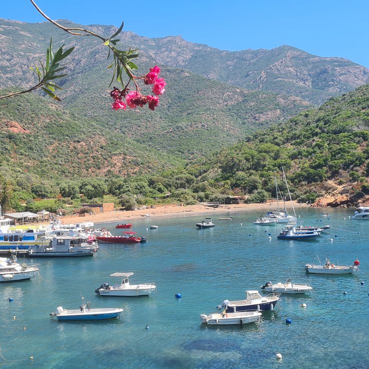
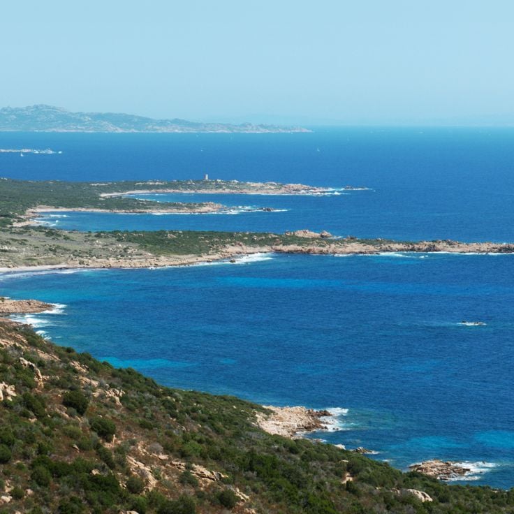
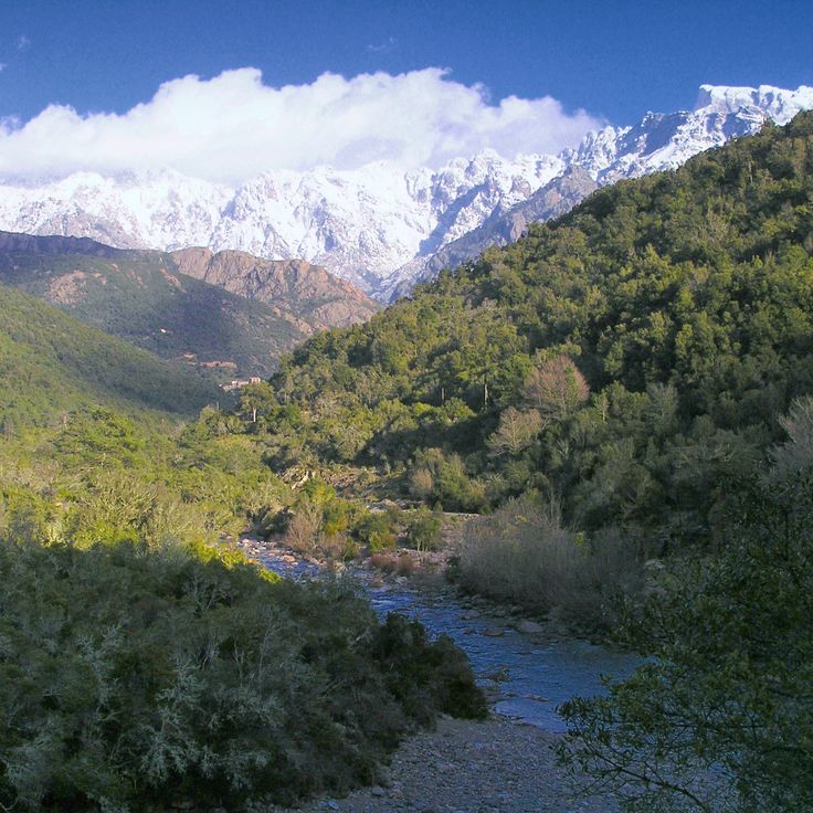
This collection connects the mountainous interior of Corsica with remote coastal sections and historical traces of early settlement. Hiking trails pass through forests and over passes to places largely untouched by mass tourism. The route includes granite formations rising from the sea and megalithic sites several thousand years old. In the mountains lie lakes of glacial origin, surrounded by pine trees and steep rock faces. Along the coast stand Genoese towers, once used for defense and now serving as landmarks. Beaches of pale sand or pebbles are often accessible only on foot or by boat. The collection leads to places such as Filitosa, where carved stelae stand among olive trees, the Calanche cliffs near Piana, whose reddish rocks are oddly shaped, and the Aiguilles de Bavella, rock spires rising above pine forests. The Scandola nature reserve extends along a jagged coastline, accessible only from the water. Monte Cinto is the island's highest peak and offers views over valleys and bays. Isolated coves such as Saleccia or Plage du Lotu lie behind hills and maquis scrubland. The collection also includes abandoned villages such as Occi, waterfalls dropping into natural pools, and trails through the Fango valley, where the river flows between granite boulders.
This collection connects the mountainous interior of Corsica with remote coastal sections and historical traces of early settlement. Hiking trails pass through forests and over passes to places largely untouched by mass tourism. The route includes granite formations rising from the sea and megalithic sites several thousand years old. In the mountains lie lakes of glacial origin, surrounded by pine trees and steep rock faces. Along the coast stand Genoese towers, once used for defense and now serving as landmarks. Beaches of pale sand or pebbles are often accessible only on foot or by boat. The collection leads to places such as Filitosa, where carved stelae stand among olive trees, the Calanche cliffs near Piana, whose reddish rocks are oddly shaped, and the Aiguilles de Bavella, rock spires rising above pine forests. The Scandola nature reserve extends along a jagged coastline, accessible only from the water. Monte Cinto is the island's highest peak and offers views over valleys and bays. Isolated coves such as Saleccia or Plage du Lotu lie behind hills and maquis scrubland. The collection also includes abandoned villages such as Occi, waterfalls dropping into natural pools, and trails through the Fango valley, where the river flows between granite boulders.
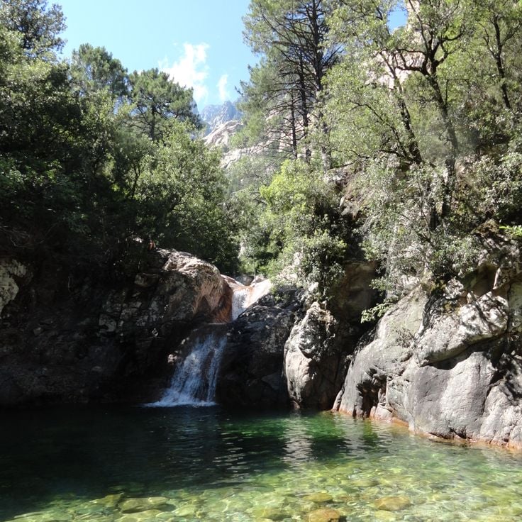
These natural pools lie in a rocky gorge in southeastern Corsica, where a stream has carved through granite. The water is cool and clear, flowing over smooth stone into several small basins. Shores of rock and low vegetation line the way. Access is by a path that crosses maquis and open ground. The pools offer shade under rock walls and are a place to bathe on warm days. The surroundings remain quiet and lightly visited, with views over rocky backcountry.
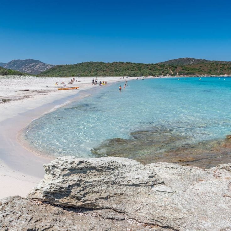
This remote beach stretches for about a kilometer along the northwestern coast, showing white sand and shallow turquoise water. Saleccia Beach sits far from any roads and can only be reached by boat or through hiking trails across dense maquis brush. The dunes behind the beach give way to low vegetation, while pine trees provide shade at the edges. The water stays clear and calm most of the day, and the few visitors usually arrive in the morning by small boats or after walking several hours.
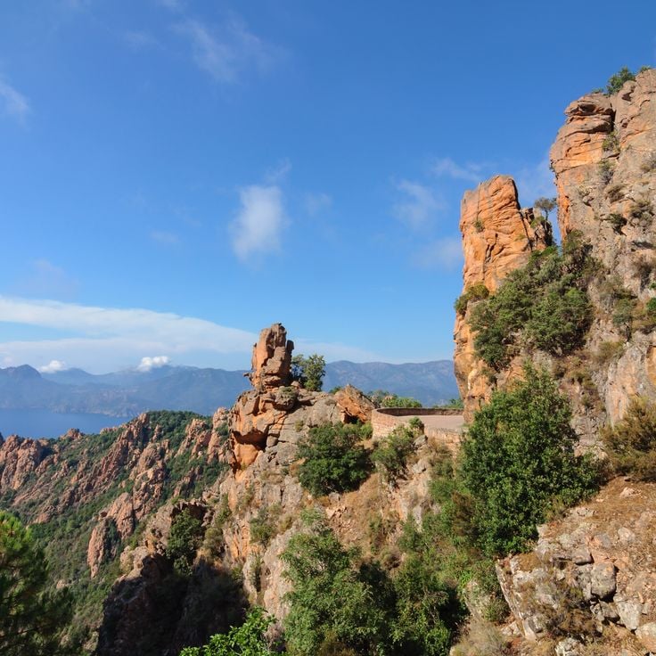
These red granite cliffs rise along the western coast and offer views over the sea. The steep rock faces show shapes formed by wind and weather. Walking trails pass between the rocks, moving through peaks and ravines. The route connects this location with other remote areas of the island.
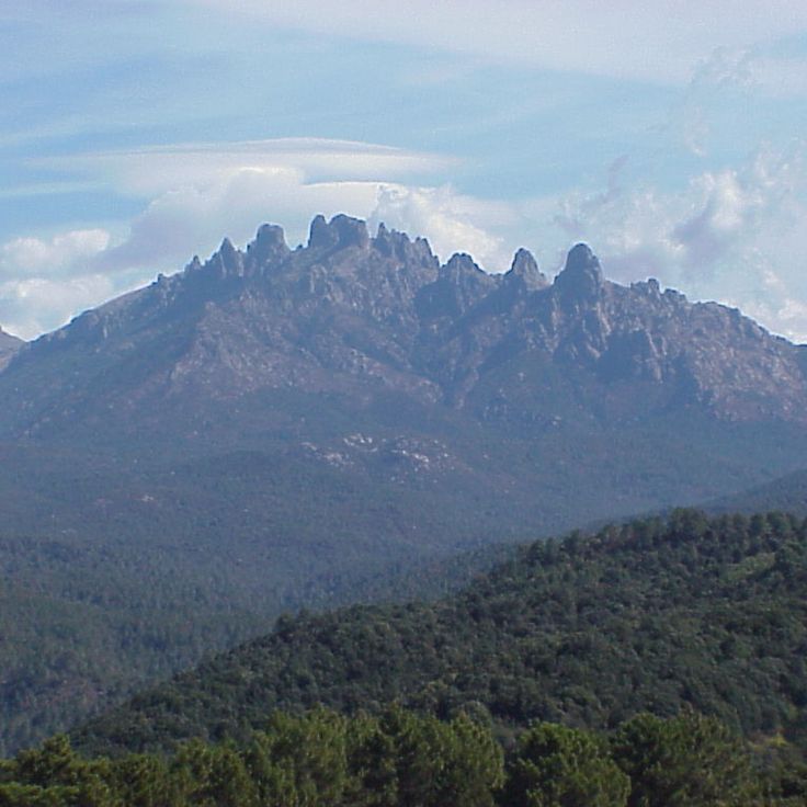
These granite peaks rise in the mountainous interior of Corsica and draw hikers through their sharp rock faces and deep gorges. The Aiguilles de Bavella form a chain of needle-like rock formations that stand above dense pine forests. The area belongs to the routes that open up the Corsican backcountry and connect prehistoric sites, Genoese towers and remote natural landscapes. Hiking paths lead through red granite rocks, past waterfalls and through mountain forests. On clear days, the view reaches the coast.
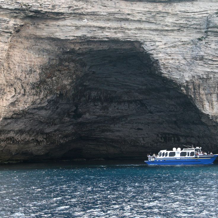
These limestone caves formed through sea erosion sit directly beneath the cliffs of Bonifacio. The water carved tunnels and chambers into the white rock over centuries. Visitors reach the caves by boat and can see the openings, narrow passages and rock formations that reflect the light of the Mediterranean in different shades of blue.
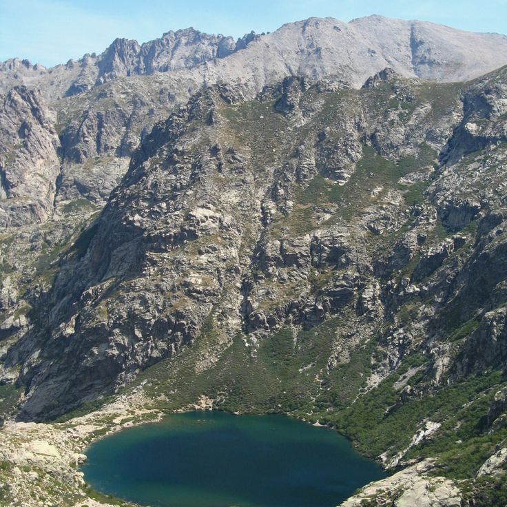
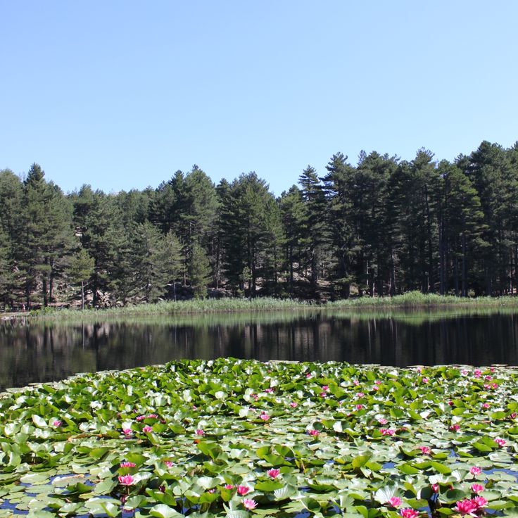
This glacial lake sits at 5612 feet (1711 meters) in the Restonica Valley, surrounded by granite rocks. The water reflects the mountains around it, while narrow trails follow the shore. Hikers reach the lake after a steep climb through pine forests and boulder fields, where the air grows cooler and the wind moves between the stones. In summer, families come here to rest by the water and dip their feet in the cold surface. The lake connects the mountain villages of Corsica with the higher peaks and serves as a stop on the way to remote mountain zones, where only rocks and patches of snow mark the land.
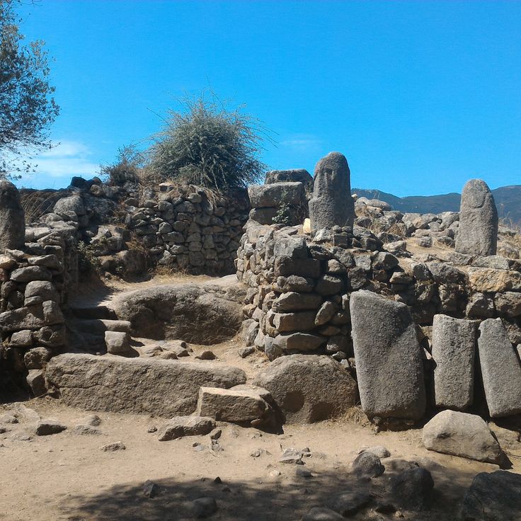
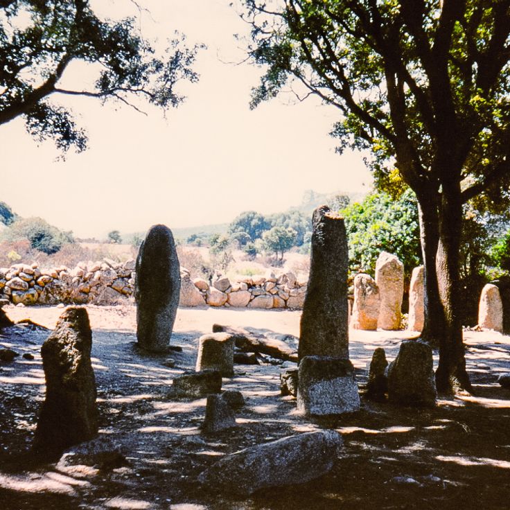
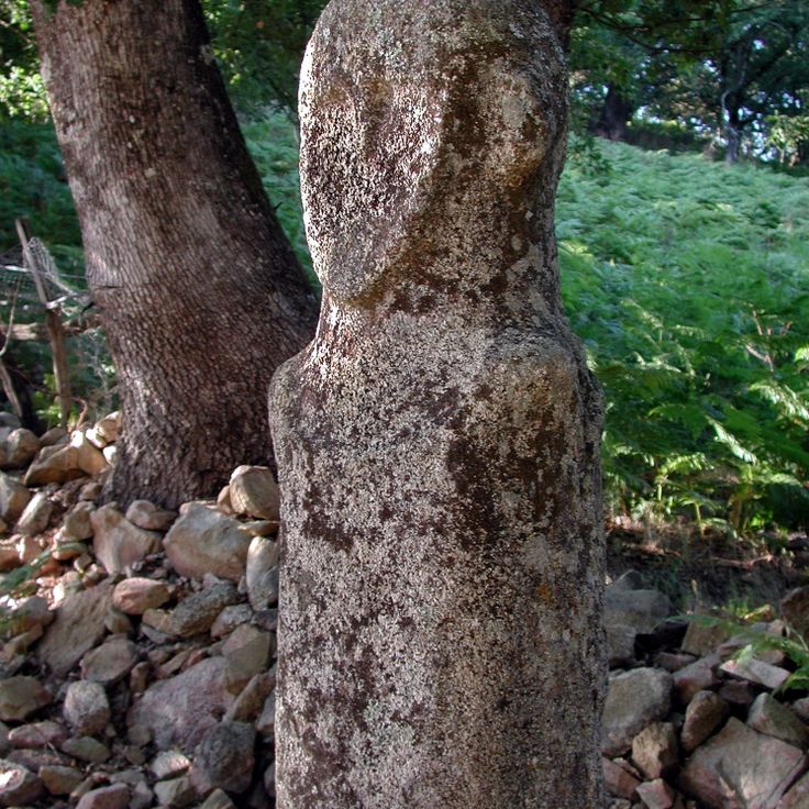
This site displays stone statues and menhirs from the Bronze Age, created between 1500 and 700 BC. Filitosa sits in a valley with old olive trees and low stone oaks. The statues carry engraved faces and weapons that you discover as you walk among the stones. The place connects prehistoric evidence with the landscape of Corsican mountains and forests, far from the coastal roads.
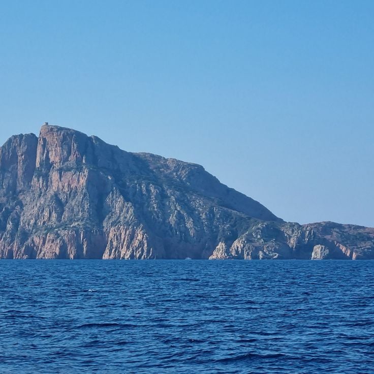
This red granite rock rises 330 meters (1,080 ft) above the sea and provides a view over the Gulf of Porto. Capu Rossu is part of the mountain landscape of Corsica, reachable from the coastal routes. The rock stands near the Genoese tower of Turghiu from the 16th century. Walking trails pass through low scrub and over smooth rock slabs. The color of the granite changes with the light of the day.
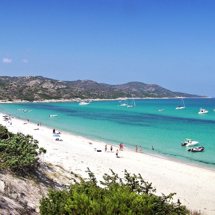
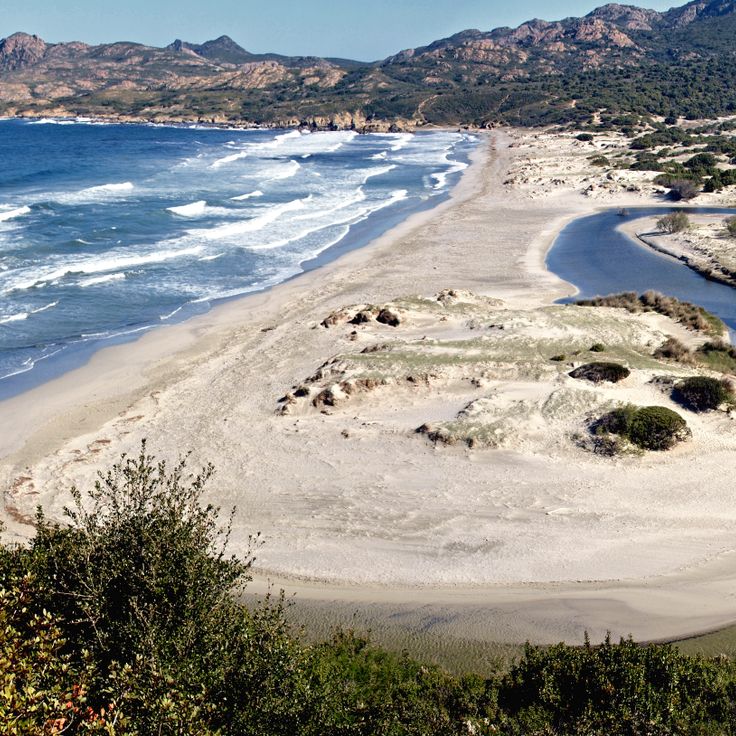
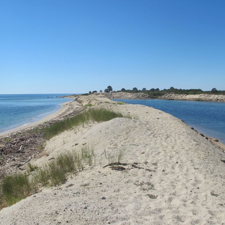
This beach runs for nearly a mile between dunes and the mouth of the Ostriconi River. The pale sand meets grassy hills in the background. Walking paths from the parking area lead through dune vegetation down to the water. At low tide, shallow pools form between sandbars. The river flows into the sea and creates a wide lagoon where birds land. In summer, families come to swim; in spring and fall, you see more walkers than bathers. Wind constantly reshapes the dunes. The color of the water shifts from green to turquoise depending on the light.
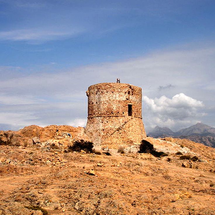
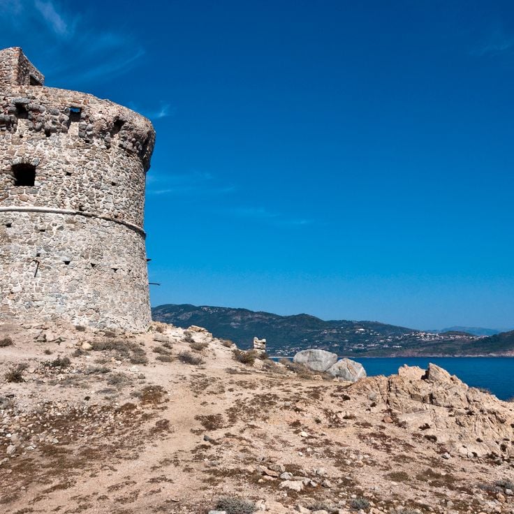
This Genoese tower from the 16th century rises from a rocky outcrop above the sea. The Tower of Senetosa served as a lookout against pirate raids and stands today as evidence of defensive architecture on the remote southwestern coast of Corsica. The path there crosses scrubland and cliffs, far from coastal roads, connecting the mountains and historical villages of the island.
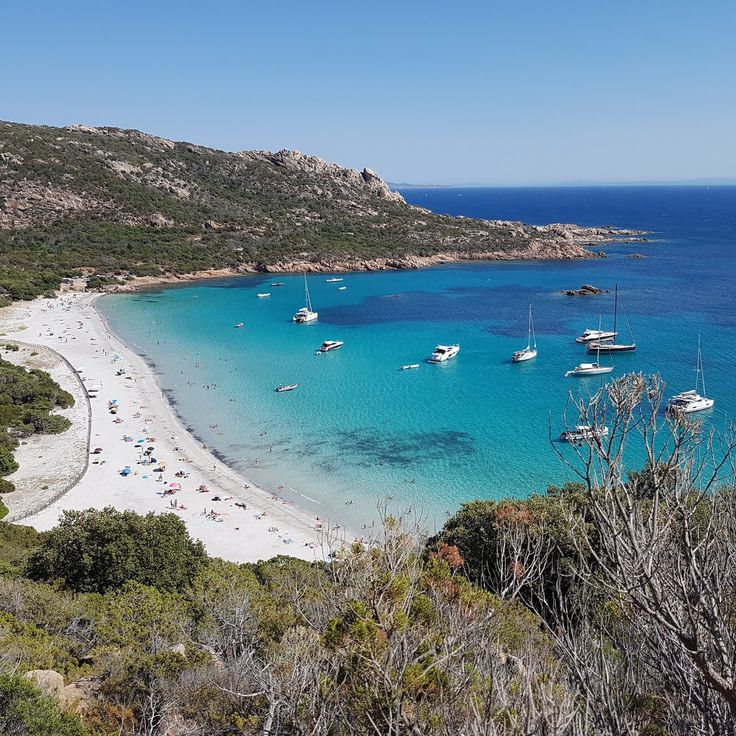
This beach lies south of Sartène and is framed by granite rocks, including a formation that resembles a lion. The sand is fine, the water clear and reaches about 75°F (24°C) in summer. The rocks provide shade in the afternoon. Access is by footpath through the maquis. The bay opens to the south and shelters from the north wind. The granite blocks in the water invite snorkeling.
This bay sits on the western side of Corsica and shelters a small fishing village with about 15 year-round residents. The Gulf of Girolata can only be reached on foot by a hiking trail of roughly three hours or by boat, which gives it a remote character. Houses stand at the edge of the water, while a Genoese tower from the 16th century watches over the village from a rock. Fishermen pull their boats onto the beach, and during summer months, excursion boats bring visitors from coastal towns. The bay is surrounded by steep slopes covered in maquis, and the clear water reflects the surrounding rocks.
The Palaggiu stone alignments stand on the hills above Sartène. This prehistoric site displays 258 upright stones from the Bronze Age. The stones form parallel rows across the field. Varied in height, they create an ancient pattern in the open landscape. The site is part of a group of important finds in this region. Access is by a short path through low scrub and grassland. These alignments connect the route to other prehistoric locations across the interior.
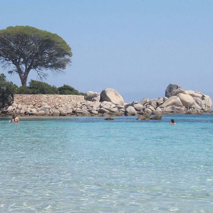
This beach sits in a sheltered cove along the eastern shore and offers visitors calm turquoise water. Granite stones line the shore and pine trees grow close to the sea. The sand is pale and fine, the water stays shallow for several yards. People come here to swim and rest in the shade of the trees. Access is through a short path across the vegetation.
This bay lies west of Ajaccio along a coastal stretch lined with steep hills and low shrub. It divides into two beaches separated by a rocky ridge. The northern part faces open water and catches wind and waves, drawing surfers who ride swells over coarse sand and rounded stones. The southern section sits more sheltered, its water calmer and its entry gentle, making it easier for swimmers. Both beaches are reached by a dirt track that winds through scrubland. In summer, cars line the track. The sea shifts through shades of blue depending on depth and light. In late afternoon the water turns golden. Some visitors stay until sunset. The coast feels raw and exposed, with little shade.
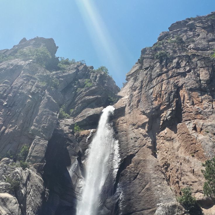
This waterfall drops about 70 meters (230 feet) through several rock levels. A marked trail leads through a pine forest to the viewpoint, offering hikers in inland Corsica a chance to experience the mountainous nature of the island.
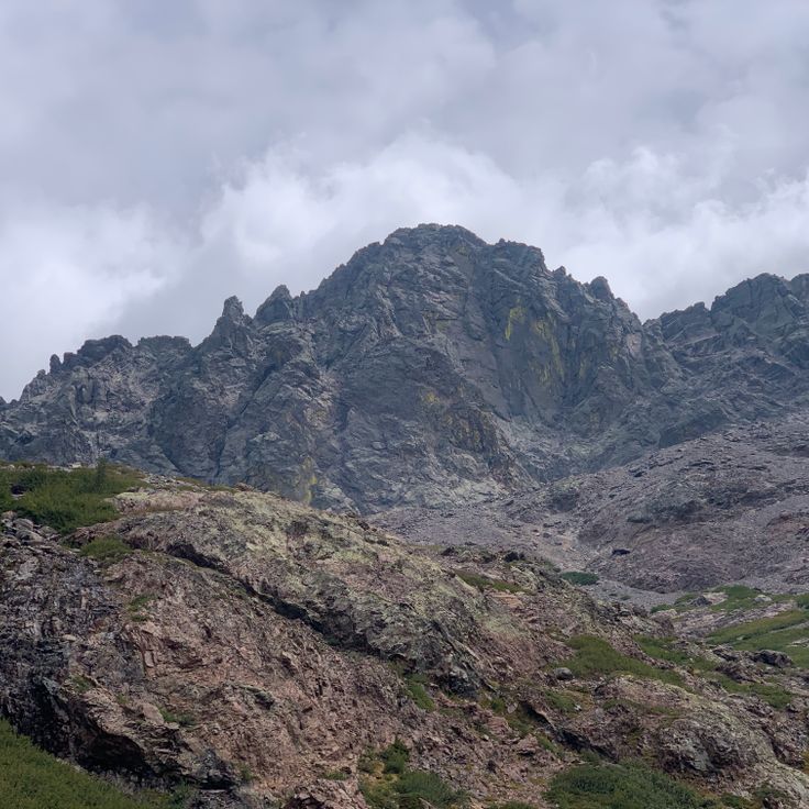
This mountain rises to 8878 feet (2706 meters), making it the highest peak in Corsica. The climb demands alpine experience and passes through rocky terrain. From the top, the whole island spreads out, from the sea to the inland valleys. The path follows stone ridges and steep slopes. In spring, snow often covers the upper sections. The final meters before the summit require sure footing and mountain navigation skills.
This granite formation shows a natural face profile in the mountains. A hiking trail leads up to the viewpoint at 1217 meters (3993 feet), where the Uomo di Cagna overlooks the valleys and forests of southern Corsica. The route connects prehistoric sites and remote places across the island.
This waterfall lies inland from Sari-Solenzara and consists of several granite basins fed by cold mountain water. The approach follows a steep path through pine forest. The natural basins offer cool swimming after the hike through the wooded slopes.
The Plage du Lotu sits on the northwestern coast of Corsica, far from paved roads and reachable only by boat or a long walking trail. This beach is among the remote places on the island, surrounded by forested hills and rocky cliffs that belong to the Désert des Agriates nature reserve. The water is clear and cold, the sand light and coarse. In summer, boats connect this beach with Saint-Florent, and during peak season the shore fills with visitors looking for quiet and untouched nature. Outside the season, the bay stays almost empty, and you hear only the sea and the wind in the maquis shrubs.
This tower from the 16th century stands on a rocky outcrop above the Gulf of Porto. The Genoese built it as part of their watch system along the Corsican coast. The cylindrical shape and thick stone walls served to protect against attacks from the sea. Signals were passed from here to other towers. The climb leads up a narrow stone staircase. At the top, a wide view opens over the cliffs and the water. The reddish color of the granite shows especially at sunset. Walking trails connect the tower with other historical sites in the mountains and valleys of the surrounding area.
This saltwater lagoon provides a complete Mediterranean wetland with typical plants. The lagoon sits away from the main roads along the coast and attracts many bird species that nest or rest in the shallow waters and reed zones. The area connects natural elements of the Corsican landscape with a quiet habitat for migratory and water birds. Visitors find a secluded environment here where water, vegetation and wildlife weave together.
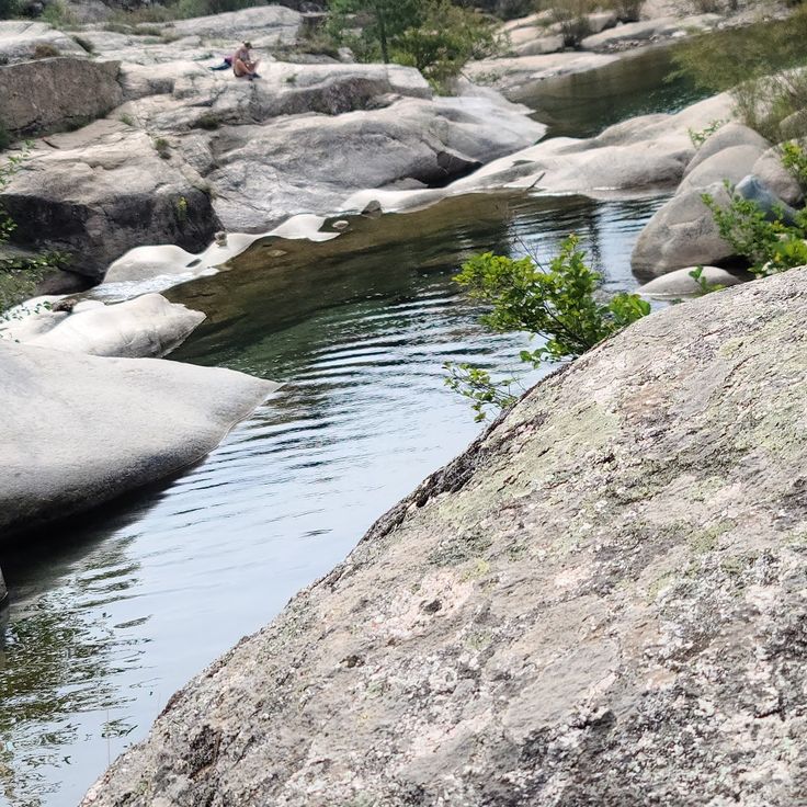
This river valley cuts through one of the wildest regions in western Corsica, with dense Mediterranean forest and gray granite boulders. The Fango flows through deep gorges, forming natural pools of clear water between the rocks. Walking trails follow the river through the nature reserve, where pigs roam freely and birds circle above the treetops. The vegetation shifts between maquis, oak and pine. Large round stones line the banks, good for resting or swimming on hot days.
This Genoese tower from the 16th century stands on a dark slate cliff above the sea. The coastline drops steeply, and the village sits on a narrow ledge above it. From here you can see far across the water and into the inland mountains. The tower was part of the coastal defense system and is now a landmark for hikers and visitors.
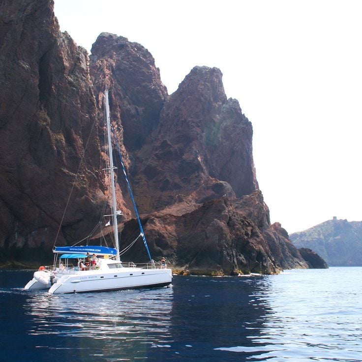
This marine protected area sits on Corsica's western coast and consists of red porphyry cliffs rising from the sea. The rocks and caves provide habitat for cormorants and other seabirds. Underwater, Posidonia seagrass meadows grow, and groupers, lobsters and octopuses move between them. The stone formed through volcanic activity and gets its color from iron oxide. You can only reach the reserve by boat, as roads do not extend this far.
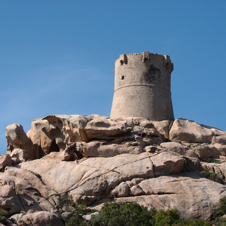
This cylindrical watchtower from the 16th century stands on a rock outcrop along the coast and once protected the area against pirates. The tower belongs to a network of Genoese fortifications on Corsica and still shows the thick stone walls and the high position that gave guards a clear view of the sea. From here, signal fires were lit to warn neighboring towers of approaching danger. The setting is quiet and the sea lies directly below the rock.
This granite headland near Ajaccio holds a lighthouse on the shore. From here you can see the red rock formations of the Sanguinaires Islands across the water. The route through Corsica's mountain terrain also leads to this spot with direct views of the Mediterranean and the offshore islands. The path crosses the cape and lets you watch the coast and open sea.
This necropolis sits on a hillside near Tavera and preserves stone tombs from the Bronze Age. The site dates to around 1500 BCE and shows how early inhabitants of Corsica buried their dead. You find burial chambers built from shaped stone blocks set into the ground. Some graves remain clearly visible while others have weathered through vegetation and erosion. Excavations uncovered pottery fragments, weapons and ornaments. The location lies away from the coastal roads in a quiet area surrounded by maquis and low trees. Those exploring the prehistoric sites of Corsica will find traces here of a community that lived in these mountains three and a half thousand years ago.
This lake sits at 4300 feet (1310 meters) among old pine trees. The water mirrors the trees and the steep slopes around it. A hiking trail leads through the forest up to the shore, where light filters through the branches and hits the surface. In summer, visitors come to sit by the edge or enjoy the quiet. The air stays cool even on warm days. Some walk on to other peaks, others stay here and watch the dark green of the pines reflected in the water.
This Genoese tower from the 16th century rises on a cliff along the western coast of Corsica. The tower was built to spot enemy ships from a distance and served as part of a communication network with neighboring watchtowers along the coast. From here, crews could observe the approach of pirates and invaders and relay warning signals by fire or smoke to other fortifications. The walls are thick and tall, typical of this kind of defensive structure. The location offers a wide view over the sea and the surrounding coves. Vegetation around the tower consists of maquis and low shrubs that withstand the wind and salty climate. On clear days, you can see far into the distance and follow the contours of the coastline.
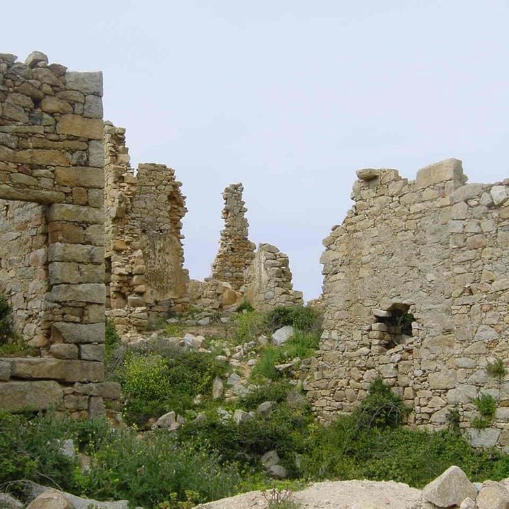
This abandoned mountain hamlet from the 13th century sits above Lumio at 377 meters (1237 feet) with open views toward the sea. Stone walls and foundations of old houses stand quietly among wild greenery that slowly reclaims the ruins. Narrow paths lead through the remains of buildings where families once lived and worked. The site lies away from the coastal roads in a quiet part of the island, where few hikers pass by. The silence and the slow return of nature give the place a particular feeling that recalls earlier times.
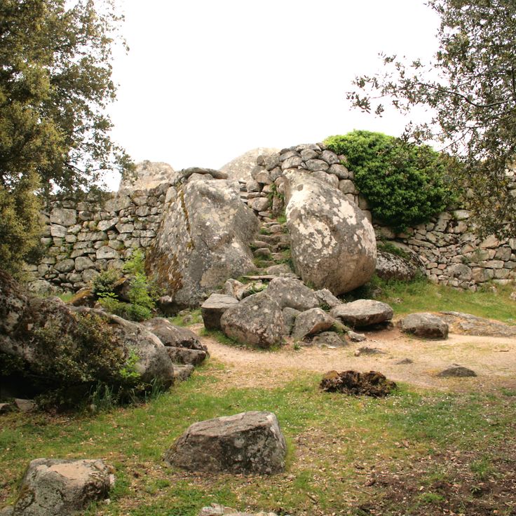
This Bronze Age fortress stands among natural granite boulders in the mountains south of Levie. The site shows walls made of uncut stones that fit between the rocks. Narrow passages lead through the complex. Cucuruzzu was a center of Torrean culture in Corsica. The structures date from a time when communities used elevated places for protection and daily life. The location lies away from coastal routes and connects with other prehistoric sites on the island.
These natural pools lie in a rocky gorge in southeastern Corsica, where a stream has carved through granite. The water is cool and clear, flowing over smooth stone into several small basins. Shores of rock and low vegetation line the way. Access is by a path that crosses maquis and open ground. The pools offer shade under rock walls and are a place to bathe on warm days. The surroundings remain quiet and lightly visited, with views over rocky backcountry.
This remote beach stretches for about a kilometer along the northwestern coast, showing white sand and shallow turquoise water. Saleccia Beach sits far from any roads and can only be reached by boat or through hiking trails across dense maquis brush. The dunes behind the beach give way to low vegetation, while pine trees provide shade at the edges. The water stays clear and calm most of the day, and the few visitors usually arrive in the morning by small boats or after walking several hours.
These red granite cliffs rise along the western coast and offer views over the sea. The steep rock faces show shapes formed by wind and weather. Walking trails pass between the rocks, moving through peaks and ravines. The route connects this location with other remote areas of the island.
These granite peaks rise in the mountainous interior of Corsica and draw hikers through their sharp rock faces and deep gorges. The Aiguilles de Bavella form a chain of needle-like rock formations that stand above dense pine forests. The area belongs to the routes that open up the Corsican backcountry and connect prehistoric sites, Genoese towers and remote natural landscapes. Hiking paths lead through red granite rocks, past waterfalls and through mountain forests. On clear days, the view reaches the coast.
These limestone caves formed through sea erosion sit directly beneath the cliffs of Bonifacio. The water carved tunnels and chambers into the white rock over centuries. Visitors reach the caves by boat and can see the openings, narrow passages and rock formations that reflect the light of the Mediterranean in different shades of blue.
This glacial lake sits at 5612 feet (1711 meters) in the Restonica Valley, surrounded by granite rocks. The water reflects the mountains around it, while narrow trails follow the shore. Hikers reach the lake after a steep climb through pine forests and boulder fields, where the air grows cooler and the wind moves between the stones. In summer, families come here to rest by the water and dip their feet in the cold surface. The lake connects the mountain villages of Corsica with the higher peaks and serves as a stop on the way to remote mountain zones, where only rocks and patches of snow mark the land.
This site displays stone statues and menhirs from the Bronze Age, created between 1500 and 700 BC. Filitosa sits in a valley with old olive trees and low stone oaks. The statues carry engraved faces and weapons that you discover as you walk among the stones. The place connects prehistoric evidence with the landscape of Corsican mountains and forests, far from the coastal roads.
This red granite rock rises 330 meters (1,080 ft) above the sea and provides a view over the Gulf of Porto. Capu Rossu is part of the mountain landscape of Corsica, reachable from the coastal routes. The rock stands near the Genoese tower of Turghiu from the 16th century. Walking trails pass through low scrub and over smooth rock slabs. The color of the granite changes with the light of the day.
This beach runs for nearly a mile between dunes and the mouth of the Ostriconi River. The pale sand meets grassy hills in the background. Walking paths from the parking area lead through dune vegetation down to the water. At low tide, shallow pools form between sandbars. The river flows into the sea and creates a wide lagoon where birds land. In summer, families come to swim; in spring and fall, you see more walkers than bathers. Wind constantly reshapes the dunes. The color of the water shifts from green to turquoise depending on the light.
This Genoese tower from the 16th century rises from a rocky outcrop above the sea. The Tower of Senetosa served as a lookout against pirate raids and stands today as evidence of defensive architecture on the remote southwestern coast of Corsica. The path there crosses scrubland and cliffs, far from coastal roads, connecting the mountains and historical villages of the island.
This beach lies south of Sartène and is framed by granite rocks, including a formation that resembles a lion. The sand is fine, the water clear and reaches about 75°F (24°C) in summer. The rocks provide shade in the afternoon. Access is by footpath through the maquis. The bay opens to the south and shelters from the north wind. The granite blocks in the water invite snorkeling.
This bay sits on the western side of Corsica and shelters a small fishing village with about 15 year-round residents. The Gulf of Girolata can only be reached on foot by a hiking trail of roughly three hours or by boat, which gives it a remote character. Houses stand at the edge of the water, while a Genoese tower from the 16th century watches over the village from a rock. Fishermen pull their boats onto the beach, and during summer months, excursion boats bring visitors from coastal towns. The bay is surrounded by steep slopes covered in maquis, and the clear water reflects the surrounding rocks.
The Palaggiu stone alignments stand on the hills above Sartène. This prehistoric site displays 258 upright stones from the Bronze Age. The stones form parallel rows across the field. Varied in height, they create an ancient pattern in the open landscape. The site is part of a group of important finds in this region. Access is by a short path through low scrub and grassland. These alignments connect the route to other prehistoric locations across the interior.
This beach sits in a sheltered cove along the eastern shore and offers visitors calm turquoise water. Granite stones line the shore and pine trees grow close to the sea. The sand is pale and fine, the water stays shallow for several yards. People come here to swim and rest in the shade of the trees. Access is through a short path across the vegetation.
This bay lies west of Ajaccio along a coastal stretch lined with steep hills and low shrub. It divides into two beaches separated by a rocky ridge. The northern part faces open water and catches wind and waves, drawing surfers who ride swells over coarse sand and rounded stones. The southern section sits more sheltered, its water calmer and its entry gentle, making it easier for swimmers. Both beaches are reached by a dirt track that winds through scrubland. In summer, cars line the track. The sea shifts through shades of blue depending on depth and light. In late afternoon the water turns golden. Some visitors stay until sunset. The coast feels raw and exposed, with little shade.
This waterfall drops about 70 meters (230 feet) through several rock levels. A marked trail leads through a pine forest to the viewpoint, offering hikers in inland Corsica a chance to experience the mountainous nature of the island.
This mountain rises to 8878 feet (2706 meters), making it the highest peak in Corsica. The climb demands alpine experience and passes through rocky terrain. From the top, the whole island spreads out, from the sea to the inland valleys. The path follows stone ridges and steep slopes. In spring, snow often covers the upper sections. The final meters before the summit require sure footing and mountain navigation skills.
This granite formation shows a natural face profile in the mountains. A hiking trail leads up to the viewpoint at 1217 meters (3993 feet), where the Uomo di Cagna overlooks the valleys and forests of southern Corsica. The route connects prehistoric sites and remote places across the island.
This waterfall lies inland from Sari-Solenzara and consists of several granite basins fed by cold mountain water. The approach follows a steep path through pine forest. The natural basins offer cool swimming after the hike through the wooded slopes.
The Plage du Lotu sits on the northwestern coast of Corsica, far from paved roads and reachable only by boat or a long walking trail. This beach is among the remote places on the island, surrounded by forested hills and rocky cliffs that belong to the Désert des Agriates nature reserve. The water is clear and cold, the sand light and coarse. In summer, boats connect this beach with Saint-Florent, and during peak season the shore fills with visitors looking for quiet and untouched nature. Outside the season, the bay stays almost empty, and you hear only the sea and the wind in the maquis shrubs.
This tower from the 16th century stands on a rocky outcrop above the Gulf of Porto. The Genoese built it as part of their watch system along the Corsican coast. The cylindrical shape and thick stone walls served to protect against attacks from the sea. Signals were passed from here to other towers. The climb leads up a narrow stone staircase. At the top, a wide view opens over the cliffs and the water. The reddish color of the granite shows especially at sunset. Walking trails connect the tower with other historical sites in the mountains and valleys of the surrounding area.
This saltwater lagoon provides a complete Mediterranean wetland with typical plants. The lagoon sits away from the main roads along the coast and attracts many bird species that nest or rest in the shallow waters and reed zones. The area connects natural elements of the Corsican landscape with a quiet habitat for migratory and water birds. Visitors find a secluded environment here where water, vegetation and wildlife weave together.
This river valley cuts through one of the wildest regions in western Corsica, with dense Mediterranean forest and gray granite boulders. The Fango flows through deep gorges, forming natural pools of clear water between the rocks. Walking trails follow the river through the nature reserve, where pigs roam freely and birds circle above the treetops. The vegetation shifts between maquis, oak and pine. Large round stones line the banks, good for resting or swimming on hot days.
This Genoese tower from the 16th century stands on a dark slate cliff above the sea. The coastline drops steeply, and the village sits on a narrow ledge above it. From here you can see far across the water and into the inland mountains. The tower was part of the coastal defense system and is now a landmark for hikers and visitors.
This marine protected area sits on Corsica's western coast and consists of red porphyry cliffs rising from the sea. The rocks and caves provide habitat for cormorants and other seabirds. Underwater, Posidonia seagrass meadows grow, and groupers, lobsters and octopuses move between them. The stone formed through volcanic activity and gets its color from iron oxide. You can only reach the reserve by boat, as roads do not extend this far.
This cylindrical watchtower from the 16th century stands on a rock outcrop along the coast and once protected the area against pirates. The tower belongs to a network of Genoese fortifications on Corsica and still shows the thick stone walls and the high position that gave guards a clear view of the sea. From here, signal fires were lit to warn neighboring towers of approaching danger. The setting is quiet and the sea lies directly below the rock.
This granite headland near Ajaccio holds a lighthouse on the shore. From here you can see the red rock formations of the Sanguinaires Islands across the water. The route through Corsica's mountain terrain also leads to this spot with direct views of the Mediterranean and the offshore islands. The path crosses the cape and lets you watch the coast and open sea.
This necropolis sits on a hillside near Tavera and preserves stone tombs from the Bronze Age. The site dates to around 1500 BCE and shows how early inhabitants of Corsica buried their dead. You find burial chambers built from shaped stone blocks set into the ground. Some graves remain clearly visible while others have weathered through vegetation and erosion. Excavations uncovered pottery fragments, weapons and ornaments. The location lies away from the coastal roads in a quiet area surrounded by maquis and low trees. Those exploring the prehistoric sites of Corsica will find traces here of a community that lived in these mountains three and a half thousand years ago.
This lake sits at 4300 feet (1310 meters) among old pine trees. The water mirrors the trees and the steep slopes around it. A hiking trail leads through the forest up to the shore, where light filters through the branches and hits the surface. In summer, visitors come to sit by the edge or enjoy the quiet. The air stays cool even on warm days. Some walk on to other peaks, others stay here and watch the dark green of the pines reflected in the water.
This Genoese tower from the 16th century rises on a cliff along the western coast of Corsica. The tower was built to spot enemy ships from a distance and served as part of a communication network with neighboring watchtowers along the coast. From here, crews could observe the approach of pirates and invaders and relay warning signals by fire or smoke to other fortifications. The walls are thick and tall, typical of this kind of defensive structure. The location offers a wide view over the sea and the surrounding coves. Vegetation around the tower consists of maquis and low shrubs that withstand the wind and salty climate. On clear days, you can see far into the distance and follow the contours of the coastline.
This abandoned mountain hamlet from the 13th century sits above Lumio at 377 meters (1237 feet) with open views toward the sea. Stone walls and foundations of old houses stand quietly among wild greenery that slowly reclaims the ruins. Narrow paths lead through the remains of buildings where families once lived and worked. The site lies away from the coastal roads in a quiet part of the island, where few hikers pass by. The silence and the slow return of nature give the place a particular feeling that recalls earlier times.
This Bronze Age fortress stands among natural granite boulders in the mountains south of Levie. The site shows walls made of uncut stones that fit between the rocks. Narrow passages lead through the complex. Cucuruzzu was a center of Torrean culture in Corsica. The structures date from a time when communities used elevated places for protection and daily life. The location lies away from coastal routes and connects with other prehistoric sites on the island.
These natural pools lie in a rocky gorge in southeastern Corsica, where a stream has carved through granite. The water is cool and clear, flowing over smooth stone into several small basins. Shores of rock and low vegetation line the way. Access is by a path that crosses maquis and open ground. The pools offer shade under rock walls and are a place to bathe on warm days. The surroundings remain quiet and lightly visited, with views over rocky backcountry.
This remote beach stretches for about a kilometer along the northwestern coast, showing white sand and shallow turquoise water. Saleccia Beach sits far from any roads and can only be reached by boat or through hiking trails across dense maquis brush. The dunes behind the beach give way to low vegetation, while pine trees provide shade at the edges. The water stays clear and calm most of the day, and the few visitors usually arrive in the morning by small boats or after walking several hours.
These red granite cliffs rise along the western coast and offer views over the sea. The steep rock faces show shapes formed by wind and weather. Walking trails pass between the rocks, moving through peaks and ravines. The route connects this location with other remote areas of the island.
These granite peaks rise in the mountainous interior of Corsica and draw hikers through their sharp rock faces and deep gorges. The Aiguilles de Bavella form a chain of needle-like rock formations that stand above dense pine forests. The area belongs to the routes that open up the Corsican backcountry and connect prehistoric sites, Genoese towers and remote natural landscapes. Hiking paths lead through red granite rocks, past waterfalls and through mountain forests. On clear days, the view reaches the coast.
These limestone caves formed through sea erosion sit directly beneath the cliffs of Bonifacio. The water carved tunnels and chambers into the white rock over centuries. Visitors reach the caves by boat and can see the openings, narrow passages and rock formations that reflect the light of the Mediterranean in different shades of blue.
This glacial lake sits at 5612 feet (1711 meters) in the Restonica Valley, surrounded by granite rocks. The water reflects the mountains around it, while narrow trails follow the shore. Hikers reach the lake after a steep climb through pine forests and boulder fields, where the air grows cooler and the wind moves between the stones. In summer, families come here to rest by the water and dip their feet in the cold surface. The lake connects the mountain villages of Corsica with the higher peaks and serves as a stop on the way to remote mountain zones, where only rocks and patches of snow mark the land.
This site displays stone statues and menhirs from the Bronze Age, created between 1500 and 700 BC. Filitosa sits in a valley with old olive trees and low stone oaks. The statues carry engraved faces and weapons that you discover as you walk among the stones. The place connects prehistoric evidence with the landscape of Corsican mountains and forests, far from the coastal roads.
This red granite rock rises 330 meters (1,080 ft) above the sea and provides a view over the Gulf of Porto. Capu Rossu is part of the mountain landscape of Corsica, reachable from the coastal routes. The rock stands near the Genoese tower of Turghiu from the 16th century. Walking trails pass through low scrub and over smooth rock slabs. The color of the granite changes with the light of the day.
This beach runs for nearly a mile between dunes and the mouth of the Ostriconi River. The pale sand meets grassy hills in the background. Walking paths from the parking area lead through dune vegetation down to the water. At low tide, shallow pools form between sandbars. The river flows into the sea and creates a wide lagoon where birds land. In summer, families come to swim; in spring and fall, you see more walkers than bathers. Wind constantly reshapes the dunes. The color of the water shifts from green to turquoise depending on the light.
This Genoese tower from the 16th century rises from a rocky outcrop above the sea. The Tower of Senetosa served as a lookout against pirate raids and stands today as evidence of defensive architecture on the remote southwestern coast of Corsica. The path there crosses scrubland and cliffs, far from coastal roads, connecting the mountains and historical villages of the island.
This beach lies south of Sartène and is framed by granite rocks, including a formation that resembles a lion. The sand is fine, the water clear and reaches about 75°F (24°C) in summer. The rocks provide shade in the afternoon. Access is by footpath through the maquis. The bay opens to the south and shelters from the north wind. The granite blocks in the water invite snorkeling.
This bay sits on the western side of Corsica and shelters a small fishing village with about 15 year-round residents. The Gulf of Girolata can only be reached on foot by a hiking trail of roughly three hours or by boat, which gives it a remote character. Houses stand at the edge of the water, while a Genoese tower from the 16th century watches over the village from a rock. Fishermen pull their boats onto the beach, and during summer months, excursion boats bring visitors from coastal towns. The bay is surrounded by steep slopes covered in maquis, and the clear water reflects the surrounding rocks.
The Palaggiu stone alignments stand on the hills above Sartène. This prehistoric site displays 258 upright stones from the Bronze Age. The stones form parallel rows across the field. Varied in height, they create an ancient pattern in the open landscape. The site is part of a group of important finds in this region. Access is by a short path through low scrub and grassland. These alignments connect the route to other prehistoric locations across the interior.
This beach sits in a sheltered cove along the eastern shore and offers visitors calm turquoise water. Granite stones line the shore and pine trees grow close to the sea. The sand is pale and fine, the water stays shallow for several yards. People come here to swim and rest in the shade of the trees. Access is through a short path across the vegetation.
This bay lies west of Ajaccio along a coastal stretch lined with steep hills and low shrub. It divides into two beaches separated by a rocky ridge. The northern part faces open water and catches wind and waves, drawing surfers who ride swells over coarse sand and rounded stones. The southern section sits more sheltered, its water calmer and its entry gentle, making it easier for swimmers. Both beaches are reached by a dirt track that winds through scrubland. In summer, cars line the track. The sea shifts through shades of blue depending on depth and light. In late afternoon the water turns golden. Some visitors stay until sunset. The coast feels raw and exposed, with little shade.
This waterfall drops about 70 meters (230 feet) through several rock levels. A marked trail leads through a pine forest to the viewpoint, offering hikers in inland Corsica a chance to experience the mountainous nature of the island.
This mountain rises to 8878 feet (2706 meters), making it the highest peak in Corsica. The climb demands alpine experience and passes through rocky terrain. From the top, the whole island spreads out, from the sea to the inland valleys. The path follows stone ridges and steep slopes. In spring, snow often covers the upper sections. The final meters before the summit require sure footing and mountain navigation skills.
This granite formation shows a natural face profile in the mountains. A hiking trail leads up to the viewpoint at 1217 meters (3993 feet), where the Uomo di Cagna overlooks the valleys and forests of southern Corsica. The route connects prehistoric sites and remote places across the island.
This waterfall lies inland from Sari-Solenzara and consists of several granite basins fed by cold mountain water. The approach follows a steep path through pine forest. The natural basins offer cool swimming after the hike through the wooded slopes.
The Plage du Lotu sits on the northwestern coast of Corsica, far from paved roads and reachable only by boat or a long walking trail. This beach is among the remote places on the island, surrounded by forested hills and rocky cliffs that belong to the Désert des Agriates nature reserve. The water is clear and cold, the sand light and coarse. In summer, boats connect this beach with Saint-Florent, and during peak season the shore fills with visitors looking for quiet and untouched nature. Outside the season, the bay stays almost empty, and you hear only the sea and the wind in the maquis shrubs.
This tower from the 16th century stands on a rocky outcrop above the Gulf of Porto. The Genoese built it as part of their watch system along the Corsican coast. The cylindrical shape and thick stone walls served to protect against attacks from the sea. Signals were passed from here to other towers. The climb leads up a narrow stone staircase. At the top, a wide view opens over the cliffs and the water. The reddish color of the granite shows especially at sunset. Walking trails connect the tower with other historical sites in the mountains and valleys of the surrounding area.
This saltwater lagoon provides a complete Mediterranean wetland with typical plants. The lagoon sits away from the main roads along the coast and attracts many bird species that nest or rest in the shallow waters and reed zones. The area connects natural elements of the Corsican landscape with a quiet habitat for migratory and water birds. Visitors find a secluded environment here where water, vegetation and wildlife weave together.
This river valley cuts through one of the wildest regions in western Corsica, with dense Mediterranean forest and gray granite boulders. The Fango flows through deep gorges, forming natural pools of clear water between the rocks. Walking trails follow the river through the nature reserve, where pigs roam freely and birds circle above the treetops. The vegetation shifts between maquis, oak and pine. Large round stones line the banks, good for resting or swimming on hot days.
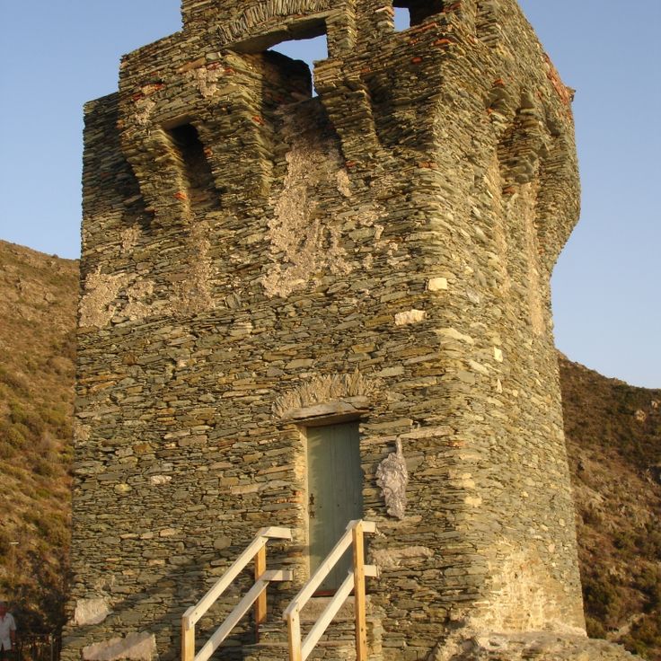
This Genoese tower from the 16th century stands on a dark slate cliff above the sea. The coastline drops steeply, and the village sits on a narrow ledge above it. From here you can see far across the water and into the inland mountains. The tower was part of the coastal defense system and is now a landmark for hikers and visitors.
This marine protected area sits on Corsica's western coast and consists of red porphyry cliffs rising from the sea. The rocks and caves provide habitat for cormorants and other seabirds. Underwater, Posidonia seagrass meadows grow, and groupers, lobsters and octopuses move between them. The stone formed through volcanic activity and gets its color from iron oxide. You can only reach the reserve by boat, as roads do not extend this far.
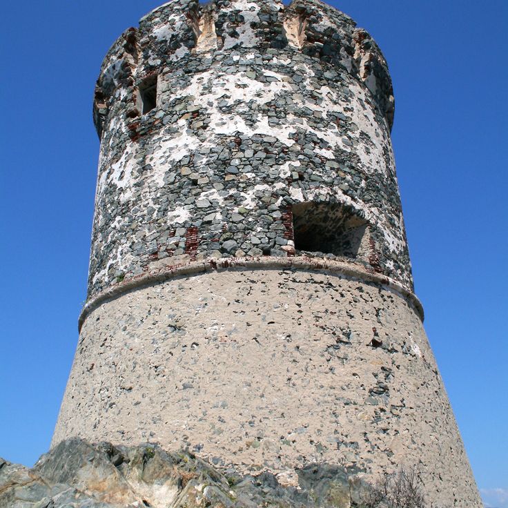
This cylindrical watchtower from the 16th century stands on a rock outcrop along the coast and once protected the area against pirates. The tower belongs to a network of Genoese fortifications on Corsica and still shows the thick stone walls and the high position that gave guards a clear view of the sea. From here, signal fires were lit to warn neighboring towers of approaching danger. The setting is quiet and the sea lies directly below the rock.
This granite headland near Ajaccio holds a lighthouse on the shore. From here you can see the red rock formations of the Sanguinaires Islands across the water. The route through Corsica's mountain terrain also leads to this spot with direct views of the Mediterranean and the offshore islands. The path crosses the cape and lets you watch the coast and open sea.
This necropolis sits on a hillside near Tavera and preserves stone tombs from the Bronze Age. The site dates to around 1500 BCE and shows how early inhabitants of Corsica buried their dead. You find burial chambers built from shaped stone blocks set into the ground. Some graves remain clearly visible while others have weathered through vegetation and erosion. Excavations uncovered pottery fragments, weapons and ornaments. The location lies away from the coastal roads in a quiet area surrounded by maquis and low trees. Those exploring the prehistoric sites of Corsica will find traces here of a community that lived in these mountains three and a half thousand years ago.
This lake sits at 4300 feet (1310 meters) among old pine trees. The water mirrors the trees and the steep slopes around it. A hiking trail leads through the forest up to the shore, where light filters through the branches and hits the surface. In summer, visitors come to sit by the edge or enjoy the quiet. The air stays cool even on warm days. Some walk on to other peaks, others stay here and watch the dark green of the pines reflected in the water.
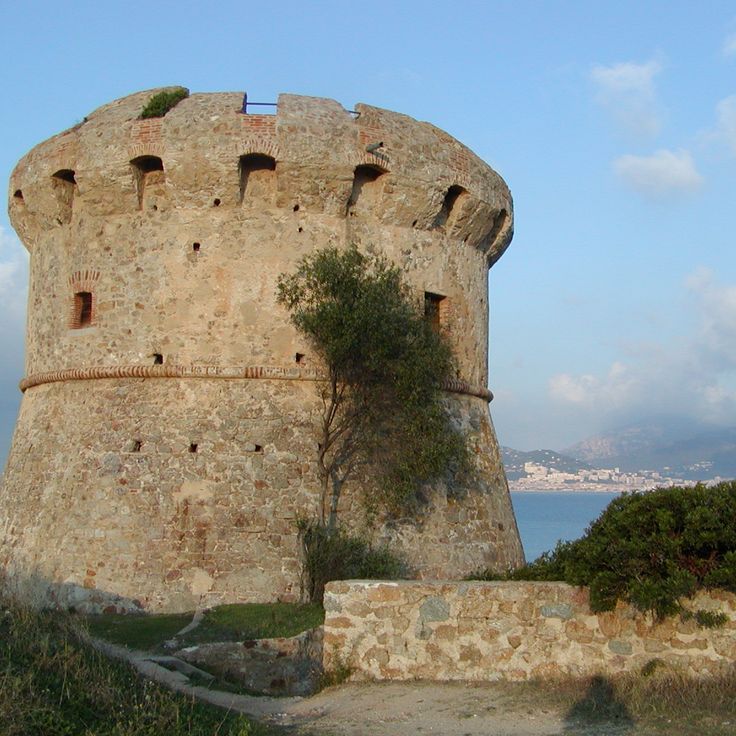
This Genoese tower from the 16th century rises on a cliff along the western coast of Corsica. The tower was built to spot enemy ships from a distance and served as part of a communication network with neighboring watchtowers along the coast. From here, crews could observe the approach of pirates and invaders and relay warning signals by fire or smoke to other fortifications. The walls are thick and tall, typical of this kind of defensive structure. The location offers a wide view over the sea and the surrounding coves. Vegetation around the tower consists of maquis and low shrubs that withstand the wind and salty climate. On clear days, you can see far into the distance and follow the contours of the coastline.
This abandoned mountain hamlet from the 13th century sits above Lumio at 377 meters (1237 feet) with open views toward the sea. Stone walls and foundations of old houses stand quietly among wild greenery that slowly reclaims the ruins. Narrow paths lead through the remains of buildings where families once lived and worked. The site lies away from the coastal roads in a quiet part of the island, where few hikers pass by. The silence and the slow return of nature give the place a particular feeling that recalls earlier times.
This Bronze Age fortress stands among natural granite boulders in the mountains south of Levie. The site shows walls made of uncut stones that fit between the rocks. Narrow passages lead through the complex. Cucuruzzu was a center of Torrean culture in Corsica. The structures date from a time when communities used elevated places for protection and daily life. The location lies away from coastal routes and connects with other prehistoric sites on the island.