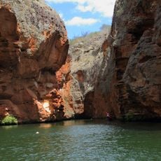
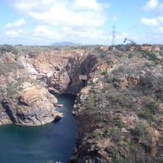
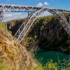
Canyon of Xingo, Canyon and water formation in Sergipe, Brazil
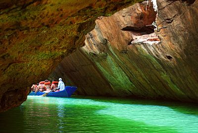
The Xingo Canyon is a river gorge along the São Francisco with steep rock walls rising above emerald-colored water. The formation stretches across a long span and narrows significantly at certain points along its course.
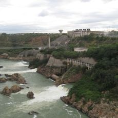
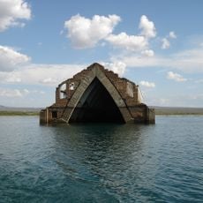
The landscape changed dramatically in 1994 when the Xingo Hydroelectric Dam was built, raising the water level significantly. This project reshaped the river valley and transformed the region for decades to come.
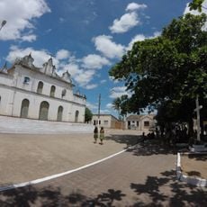
Indigenous peoples live in the areas surrounding the canyon and maintain their ways of life along the São Francisco River. Visitors can observe today how these communities remain connected to the water and the land around them.
Visitors depart by boat from the port at Caninde de São Francisco, with typical outings lasting several hours and including swimming breaks. It helps to arrive early and bring sun protection for comfort on the water.
The gorge ranks among the world's largest navigable river canyons and has points where the rock walls close in dramatically. These narrow passages create an intense feeling of being surrounded by near-vertical stone faces.
Location: Sergipe
GPS coordinates: -9.52880,-37.97540
Latest update: December 6, 2025 17:43
Brazilian architectural heritage reflects centuries of history, from colonial fortifications to contemporary structures. In São Paulo, the Flag Monument pays tribute to colonial expeditions, while in Belém, the Peace Theater recalls the prosperity of the rubber era. In Curitiba, the Oscar Niemeyer...
Catimbau National Park
136.2 km
Paulo Afonso Hydroelectric Complex
28.9 km
Bendegó meteorite
155.5 km
Paulo Afonso Falls
28.8 km
Serra de Itabaiana National Park
155.2 km
Rio São Francisco Natural Monument
3.5 km
Usina Hidrelétrica de Angiquinho
28.5 km
Parque dos Falcões
150.7 km
Canudos State Park
130.9 km
Igreja de Nossa Senhora do Rosário
122.1 km
Museu do Sertão
26.5 km
Chapel of the Nossa Senhora da Penha Sugar Plantation
154.5 km
Casa de Graciliano Ramos
148.5 km
Serra Branca / Raso da Catarina Environmental Protection Area
80.4 km
Igreja Matriz do Santuário Nossa Senhora Divina Pastora
156.9 km
Igreja Santo Antônio de Pádua
72 km
Capela do Engenho Nossa Senhora da Penha
154.5 km
Igreja de Nossa Senhora da Conceição dos Pardos (Laranjeiras)
167.2 km
Teatro São Pedro
167.1 km
Grupo Escolar Coronel João Fernandes de Brito
146.4 km
Igreja Matriz do Senhor da Ascensão
144.8 km
Cine Laser Itabaiana
145.4 km
Parish Church of Divina Pastora
156.9 km
Mother Church of Nossa Senhora da Boa Hora and São Roque (Campo do Brito/SE)
145.6 km
Former Police Station of Laranjeiras
167.1 km
Old Petrolandia Church
64.8 km
Igreja Matriz de Senhora Santana
135.9 km
Ponte Metálica Dom Pedro II
27.3 kmVisited this place? Tap the stars to rate it and share your experience / photos with the community! Try now! You can cancel it anytime.
Discover hidden gems everywhere you go!
From secret cafés to breathtaking viewpoints, skip the crowded tourist spots and find places that match your style. Our app makes it easy with voice search, smart filtering, route optimization, and insider tips from travelers worldwide. Download now for the complete mobile experience.
A unique approach to discovering new places❞
— Le Figaro
All the places worth exploring❞
— France Info
A tailor-made excursion in just a few clicks❞
— 20 Minutes