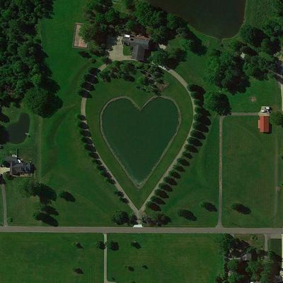
Heart-Shaped pond, Artificial pond in Columbia Township, United States
The Heart-Shaped Pond is an artificial water body in Columbia Township with a distinctive heart configuration created through engineered design. Pathways run along the perimeter, allowing visitors to view the water from multiple vantage points and see how the shape forms the entire water's edge.
The pond was created in the early 1900s as a designed project within the township. The heart shape was intentional from the start, giving the location a distinctive identity that residents and visitors could recognize.
The heart shape of the water draws couples and visitors seeking a meaningful setting, making it a gathering spot for romantic occasions. People visit to spend time together at the water's edge and capture moments that reflect what the place represents to them.
The site is open during standard park hours, and marked paths guide visitors around the water's edge. The relatively flat terrain makes it easy to walk the perimeter and find good spots for viewing and taking photos from different angles.
From above, the water reveals its complete heart pattern in a way that ground-level views cannot fully capture, making it especially rewarding for aerial photography. The geometric precision of the design becomes much more apparent when seen from this higher perspective.
Location: Columbia Township
GPS coordinates: 41.30393,-81.90170
Latest update: December 6, 2025 19:10
Heart-shaped geographic formations result from natural processes including erosion, coral growth, and tectonic activity. These features appear in various landscape types, from islands and atolls to lakes and coastlines. The distinctive shape typically becomes apparent only from aerial perspectives, making these locations popular destinations for scenic flights and aerial photography. Examples occur worldwide: the Heart Reef within Australia's Great Barrier Reef, Galešnjak Island in Croatia's Adriatic Sea, and Lake Toyoni on Japan's Hokkaido Island. Additional formations exist in the waters of French Polynesia and along North American coastlines. These sites combine geological interest with their symbolic shape, attracting visitors who seek both natural environments and the opportunity to witness these formations from above.
Crocker Park
17.8 km
Zero Gravity Research Facility
12.5 km
Rocket Engine Test Facility
11.5 km
Westlake Porter Public Library
16.1 km
Grand Pacific Junction
7.8 km
John and Maria Adams House
8.8 km
Gardenview Horticultural Park
5.9 km
John Wheeler House
7.5 km
Baldwin–Wallace College South Campus Historic District
8.3 km
St. Martin's Catholic Church
9.9 km
John M. Annis House
15.4 km
First Universalist Church of Olmsted
12.7 km
Burrell Memorial Observatory
9 km
Old District 10 Schoolhouse
11.9 km
Baldwin-Wallace College North Campus Historic District
8.9 km
Buehl House
8.2 km
Walter F. Ehrnfelt Bridge
6.9 km
Olmsted Falls Depot and Model Railroad Museum
7.9 km
The Berea Triangle
8 km
Frostville Museum
11.4 km
Berea Union Depot
9.4 km
Woodvale Union Cemetery historical marker
8.9 km
Astronaut Robert Franklyn Overmyer
18.1 km
The Ark
9.1 km
Harding Memorial Bridge
8.2 km
Old District 10 Schoolhouse
11.9 km
Baldwin University
8.7 km
Columbia Township
2.4 kmVisited this place? Tap the stars to rate it and share your experience / photos with the community! Try now! You can cancel it anytime.
Discover hidden gems everywhere you go!
From secret cafés to breathtaking viewpoints, skip the crowded tourist spots and find places that match your style. Our app makes it easy with voice search, smart filtering, route optimization, and insider tips from travelers worldwide. Download now for the complete mobile experience.
A unique approach to discovering new places❞
— Le Figaro
All the places worth exploring❞
— France Info
A tailor-made excursion in just a few clicks❞
— 20 Minutes