Enable Location

We need your location to show you interesting places around you

Discover nearby places

Find interesting locations and hidden gems around you

Precise directions

Get accurate directions and distances to places

Your location is never shared with other users. It's only used when you tap the location button.

Beede Falls

Log in to your account

Start exploring — it's free

Trusted by 62,984 travelers worldwide

Continue with Google
Continue with Apple
or

We will send you a code to connect

By continuing, you accept our Terms and Conditions and our Privacy Policy

Check your inbox

We've sent a pincode in your inbox. Please enter the code below.

Beede Falls
Discussion Reviews 1 Photos 1 Collections
10+ Popularity

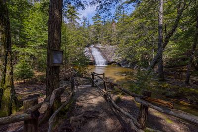
Beede Falls, Waterfall in Sandwich, New Hampshire.

Beede Falls is a waterfall in Sandwich, New Hampshire, featuring two distinct sections of cascading water. The upper section forms a strong vertical drop, while the lower area contains several smaller slides that pool before flowing downstream.

The falls gained recognition through its documentation in New England hiking guides and regional waterfall records. Over time, it became established as a known destination within the broader Sandwich Notch area.

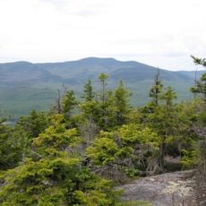
The falls draw visitors year-round, especially those seeking natural swimming spots in the area. People come to experience the waterfall as part of their outdoor adventures in the White Mountains region.

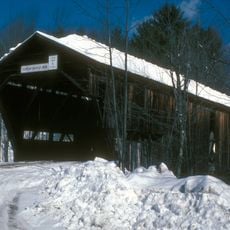
A marked trail of less than 1 mile reaches the falls and is accessible year-round from Diamond Ledge Road. Water flow varies by season, so plan your visit knowing that spring and early summer bring the most powerful cascades.

During high water periods, whitewater kayakers paddle through the falls seeking an adrenaline rush from the rapids. A small wooden bridge near the cascade provides photographers with a vantage point for capturing the water in motion.

The community of curious travelers

AroundUs brings together thousands of curated places, local tips, and hidden gems, enriched daily by 60,000 contributors worldwide.

Start exploring
Location
GPS coordinates
43.82742,-71.49268
Latest update
December 6, 2025 19:09
Hidden sites in New Hampshire between white mountains and ancient forests

New Hampshire reveals a land where the White Mountains have shaped the skyline for millennia. Between northern coniferous forests and southeastern Atlantic coasts, this New England state features waterfalls cascading over granite, glacial passes carved 15,000 years ago, and industrial villages...

Around this place
United States of America

Mount Tecumseh

16.3 km
Sandwich Mountain
United States of America

Sandwich Mountain

8.1 km
Swallow Boathouse
United States of America

Swallow Boathouse

16.2 km
Mount Roberts
United States of America

Mount Roberts

15.6 km
Blair Bridge
United States of America

Blair Bridge

14 km
Rockywold-Deephaven Camps
United States of America

Rockywold-Deephaven Camps

7 km
Burleigh Brae and Webster Boathouse
United States of America

Burleigh Brae and Webster Boathouse

9.1 km
Webster Estate
United States of America

Webster Estate

9.2 km
Durgin Bridge
United States of America

Durgin Bridge

10.8 km
True Farm
United States of America

True Farm

9.2 km
Camp Carnes
United States of America

Camp Carnes

8.9 km
Chapel of the Holy Cross
United States of America

Chapel of the Holy Cross

16.6 km
Holderness Free Library
United States of America

Holderness Free Library

13.1 km
Camp Ossipee
United States of America

Camp Ossipee

10.3 km
Boulderwood
United States of America

Boulderwood

10 km
Town Hall
United States of America

Town Hall

4.9 km
Beede Farm
United States of America

Beede Farm

3.9 km
North Sandwich Meeting House
United States of America

North Sandwich Meeting House

10.8 km
Moultonborough Town House
United States of America

Moultonborough Town House

11.2 km
Shepard Hill Historic District
United States of America

Shepard Hill Historic District

13 km
Centre Harbor Village Historic District
United States of America

Centre Harbor Village Historic District

13.4 km
High, Church and Gould Streets Historic District
United States of America

High, Church and Gould Streets Historic District

8.6 km
North Holderness Freewill Baptist Church-Holderness Historical Society Building
United States of America

North Holderness Freewill Baptist Church-Holderness Historical Society Building

13.2 km
Bradbury Jewell House
United States of America

Bradbury Jewell House

14 km
Pointfield
United States of America

Pointfield

5.6 km
Hansen's Annex
United States of America

Hansen's Annex

4.9 km
Lower Corner Historic District
United States of America

Lower Corner Historic District

7.5 km
Center Sandwich Historic District
United States of America

Center Sandwich Historic District

4.8 km
Show the full map
Reviews
Share your experience

No review yet

Discussions
Start a discussion...

No discussion yet

« Beede Falls - Waterfall in Sandwich, New Hampshire » is provided by Around Us (aroundus.com). Images and texts are derived from Wikimedia project under a Creative Commons license. You are allowed to copy, distribute, and modify copies of this page, under the conditions set by the license, as long as this note is clearly visible.

Discover hidden gems everywhere you go!

From secret cafés to breathtaking viewpoints, skip the crowded tourist spots and find places that match your style. Our app makes it easy with voice search, smart filtering, route optimization, and insider tips from travelers worldwide. Download now for the complete mobile experience.

Around Us App Screenshot

A unique approach to discovering new places

Le Figaro

All the places worth exploring

France Info

A tailor-made excursion in just a few clicks

20 Minutes

Around Us
Travel Guide & Maps
Download

Send to your phone

QR Code
1

Open the camera app on your mobile.

2

Point at the QR code with your camera. A notification will appear.

3

Tap the notification to open the link.