Enable Location

We need your location to show you interesting places around you

Discover nearby places

Find interesting locations and hidden gems around you

Precise directions

Get accurate directions and distances to places

Your location is never shared with other users. It's only used when you tap the location button.

Blair Bridge

Log in to your account

Start exploring — it's free

Trusted by 62,992 travelers worldwide

Continue with Google
Continue with Apple
or

We will send you a code to connect

By continuing, you accept our Terms and Conditions and our Privacy Policy

Check your inbox

We've sent a pincode in your inbox. Please enter the code below.

Blair Bridge
Discussion Reviews 1 Photos
1.8k Popularity

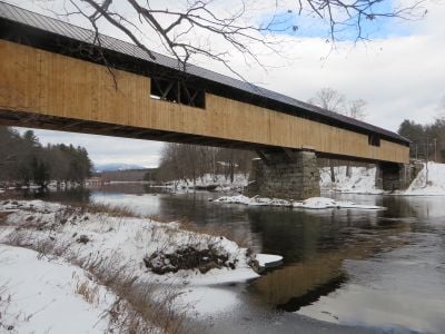
Blair Bridge, Covered bridge in Campton, United States

Blair Bridge is a covered wooden structure spanning the Pemigewasset River with a single arch design and traditional New England construction. The interior features a high wooden roof and an open roadway typical of bridges built in this era.

The structure was built in 1829 and has served the region since its construction. Following major damage from Tropical Storm Irene in 2011, it received extensive repairs and reopened in 2015 with improved load capacity.

The bridge represents traditional New England craftsmanship and shows construction methods that locals have valued for generations. Visitors can observe the handmade details and sturdy wood construction that define bridges from this region.

The crossing accommodates only one vehicle at a time due to its narrow single-lane design. Drivers should proceed slowly and be prepared to stop if meeting another vehicle coming from the opposite direction.

The structure connects two significant state and federal routes while holding historical marker number 196 in the state registry. This strategic location makes it a notable transition point for travelers moving between different landscapes in the region.

The community of curious travelers

AroundUs brings together thousands of curated places, local tips, and hidden gems, enriched daily by 60,000 contributors worldwide.

Start exploring
Location
GPS coordinates
43.81000,-71.66530
Latest update
December 14, 2025 11:20
Around this place
Hubbard Brook Experimental Forest
United States of America

Hubbard Brook Experimental Forest

15.3 km
Sandwich Mountain
United States of America

Sandwich Mountain

16.8 km
Rockywold-Deephaven Camps
United States of America

Rockywold-Deephaven Camps

10.5 km
Burleigh Brae and Webster Boathouse
United States of America

Burleigh Brae and Webster Boathouse

9.9 km
Webster Estate
United States of America

Webster Estate

10.2 km
Whipple House
United States of America

Whipple House

13.1 km
True Farm
United States of America

True Farm

9.7 km
First Free Will Baptist Church and Vestry
United States of America

First Free Will Baptist Church and Vestry

13.1 km
Camp Carnes
United States of America

Camp Carnes

10.2 km
Chapel of the Holy Cross
United States of America

Chapel of the Holy Cross

5.8 km
Holderness Free Library
United States of America

Holderness Free Library

10.8 km
Camp Ossipee
United States of America

Camp Ossipee

11.9 km
Ashland Gristmill and Dam
United States of America

Ashland Gristmill and Dam

13 km
Old Grafton County Courthouse
United States of America

Old Grafton County Courthouse

6.1 km
Boulderwood
United States of America

Boulderwood

12 km
Beede Farm
United States of America

Beede Farm

15.2 km
Norman and Marion Perry House
United States of America

Norman and Marion Perry House

5.6 km
Ashland Town Hall
United States of America

Ashland Town Hall

12.9 km
Shepard Hill Historic District
United States of America

Shepard Hill Historic District

12.1 km
Plymouth Historic District
United States of America

Plymouth Historic District

6.2 km
North Holderness Freewill Baptist Church-Holderness Historical Society Building
United States of America

North Holderness Freewill Baptist Church-Holderness Historical Society Building

7.8 km
Hebron Village Historic District
United States of America

Hebron Village Historic District

17.2 km
Pointfield
United States of America

Pointfield

15.5 km
Owls Head
United States of America

Owls Head

17.7 km
Hansen's Annex
United States of America

Hansen's Annex

18.2 km
Ashland
United States of America

Ashland

13.6 km
Center Sandwich Historic District
United States of America

Center Sandwich Historic District

18.1 km
Beede Falls
United States of America

Beede Falls

14 km
Show the full map
Reviews
Share your experience

No review yet

Discussions
Start a discussion...

No discussion yet

« Blair Bridge - Covered bridge in Campton, United States » is provided by Around Us (aroundus.com). Images and texts are derived from Wikimedia project under a Creative Commons license. You are allowed to copy, distribute, and modify copies of this page, under the conditions set by the license, as long as this note is clearly visible.

Discover hidden gems everywhere you go!

From secret cafés to breathtaking viewpoints, skip the crowded tourist spots and find places that match your style. Our app makes it easy with voice search, smart filtering, route optimization, and insider tips from travelers worldwide. Download now for the complete mobile experience.

Around Us App Screenshot

A unique approach to discovering new places

Le Figaro

All the places worth exploring

France Info

A tailor-made excursion in just a few clicks

20 Minutes

Around Us
Travel Guide & Maps
Download

Send to your phone

QR Code
1

Open the camera app on your mobile.

2

Point at the QR code with your camera. A notification will appear.

3

Tap the notification to open the link.