Enable Location

We need your location to show you interesting places around you

Discover nearby places

Find interesting locations and hidden gems around you

Precise directions

Get accurate directions and distances to places

Your location is never shared with other users. It's only used when you tap the location button.

Makapuʻu Point Lighthouse Trail

Log in to your account

Start exploring — it's free

Trusted by 62,186 travelers worldwide

Continue with Google
Continue with Apple
or

We will send you a code to connect

By continuing, you accept our Terms and Conditions and our Privacy Policy

Check your inbox

We've sent a pincode in your inbox. Please enter the code below.

Makapuʻu Point Lighthouse Trail

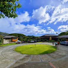
Makapuʻu Point Lighthouse Trail, Coastal hiking trail at Kaiwi State Scenic Shoreline, Hawaii, US

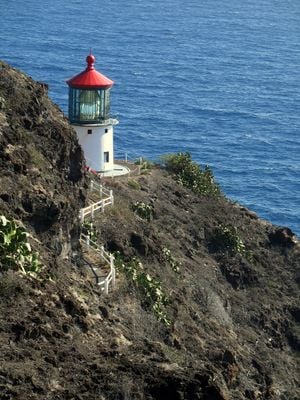
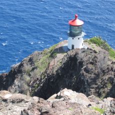
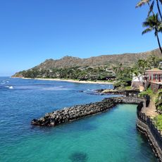
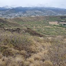
The Makapuʻu Point Lighthouse Trail is a coastal route with a paved surface that climbs steadily toward a white lighthouse structure overlooking Oahu's southeastern shore. The path includes multiple viewpoints where you can look out toward the ocean and surrounding cliffs.

The lighthouse was built in 1909 to guide ships navigating the waters off Oahu's eastern point. The structure has remained in place for over a century as a steady navigation marker on the coastline.

The name Makapuʻu comes from Hawaiian and refers to the distinctive cliff formations that rise above the Pacific Ocean. You can see how these natural features shape the entire landscape as you walk the trail.

The trail is open daily from sunrise to sunset and you should bring water, sun protection, and sturdy shoes since the path is very exposed. Wind can be strong and variable, so be prepared for changing conditions.

Between December and April, visitors can spot humpback whales migrating through the waters below from several viewing areas along the trail. These sightings are not guaranteed, but many hikers time their visit during these months hoping to witness the whales passing by.

The community of curious travelers

AroundUs brings together thousands of curated places, local tips, and hidden gems, enriched daily by 60,000 contributors worldwide.

Start exploring
Location
GPS coordinates
21.30933,-157.65067
Latest update
December 6, 2025 19:08
Hawaii: natural sites, beaches and historical places

The Hawaiian Islands offer beaches with white, black, and red sand, formed through volcanic activity and coral erosion. Coastal areas display tide pools, sea caves, and lava formations. Inland, hiking trails lead through rainforest valleys to waterfalls and historic Heiau temples, which served as...

Around this place
Lanikai Beach
United States of America

Lanikai Beach

11.4 km
Interstate H-3
United States of America

Interstate H-3

16.4 km
Manoa Falls
United States of America

Manoa Falls

15.8 km
Plantation Estate
United States of America

Plantation Estate

15.9 km
Shangri La Museum
United States of America

Shangri La Museum

16.1 km
Sandy Beach
United States of America

Sandy Beach

3.5 km
Lyon Arboretum
United States of America

Lyon Arboretum

16.1 km
Koko Crater
United States of America

Koko Crater

4.3 km
Koko Crater Botanical Garden
United States of America

Koko Crater Botanical Garden

4 km
Makapuu Point Light
United States of America

Makapuu Point Light

630 m
Ulupo Heiau State Historic Site
United States of America

Ulupo Heiau State Historic Site

13.6 km
Boettcher Estate
United States of America

Boettcher Estate

14 km
Bellows Field Beach Park
United States of America

Bellows Field Beach Park

8.1 km
Charles Montague Cooke, Jr., House and Kūkaʻōʻō Heiau
United States of America

Charles Montague Cooke, Jr., House and Kūkaʻōʻō Heiau

17.2 km
Holy Trinity Catholic Church
United States of America

Holy Trinity Catholic Church

8.7 km
Kaneohe Ranch Building
United States of America

Kaneohe Ranch Building

15.8 km
Lemon Wond Holt House
United States of America

Lemon Wond Holt House

15.2 km
Manoa Heritage Center
United States of America

Manoa Heritage Center

17 km
Jessie Eyman–Wilma Judson House
United States of America

Jessie Eyman–Wilma Judson House

15.8 km
Shangri La Museum of Islamic Art, Culture & Design
United States of America

Shangri La Museum of Islamic Art, Culture & Design

16.1 km
Pele's Chair
United States of America

Pele's Chair

1.3 km
Island Sound Studios
United States of America

Island Sound Studios

6.5 km
Saint Louis School
United States of America

Saint Louis School

16.4 km
Bartlett Cooper House
United States of America

Bartlett Cooper House

14 km
Kuilei Cliffs
United States of America

Kuilei Cliffs

17.1 km
Nuʻuanu Pali Lookout
United States of America

Nuʻuanu Pali Lookout

16.1 km
Fort Ruger Park
United States of America

Fort Ruger Park

16.1 km
Makapuʻu Lookout
United States of America

Makapuʻu Lookout

640 m
Show the full map
« Makapuʻu Point Lighthouse Trail - Coastal hiking trail at Kaiwi State Scenic Shoreline, Hawaii, US » is provided by Around Us (aroundus.com). Images and texts are derived from Wikimedia project under a Creative Commons license. You are allowed to copy, distribute, and modify copies of this page, under the conditions set by the license, as long as this note is clearly visible.

Discover hidden gems everywhere you go!

From secret cafés to breathtaking viewpoints, skip the crowded tourist spots and find places that match your style. Our app makes it easy with voice search, smart filtering, route optimization, and insider tips from travelers worldwide. Download now for the complete mobile experience.

Around Us App Screenshot

A unique approach to discovering new places

Le Figaro

All the places worth exploring

France Info

A tailor-made excursion in just a few clicks

20 Minutes

Around Us
Travel Guide & Maps
Download

Send to your phone

QR Code
1

Open the camera app on your mobile.

2

Point at the QR code with your camera. A notification will appear.

3

Tap the notification to open the link.