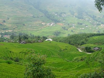
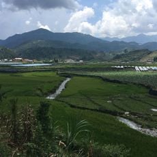
Muong Hoa Valley, Rice terrace valley in Sa Pa, Vietnam.
Muong Hoa Valley is a river valley in Sa Pa characterized by stepped rice paddies covering the mountainsides and a stream running through its center. The terrain spans across multiple villages and combines natural mountain slopes with agricultural terracing.
An archaeological site containing nearly 200 carved stone blocks was discovered in 1925, revealing traces of earlier human settlement in the region. These findings show that the valley has been inhabited and used by people for a considerable time.
The H'mong, Dao, and Giay people live throughout the valley and practice traditional crafts that have been passed down for generations. You can see intricate embroidery, batik work, and handmade jewelry in the villages as part of everyday life.
The best time to visit is from March to May and September to November, when weather conditions are clear and temperatures remain moderate. These months allow for comfortable exploration without dealing with heavy rain or excessive heat.
A funicular railway system connects Sa Pa town to a mountain station, offering views of the entire valley from above. This modern infrastructure lets you see the landscape from a completely different vantage point.
Location: Sa Pa
GPS coordinates: 22.31450,103.87737
Latest update: December 6, 2025 19:08
Vietnam extends more than 1,000 miles (1,600 kilometers) from mountain regions in the north to the Mekong Delta in the south, offering travelers a wide range of natural and historical sites beyond urban centers. The country includes Buddhist temples like Bai Dinh and Thien Mu Pagoda, cave systems such as Son Doong and Hang En, and rice terraces at Y Ty and Hoang Su Phi. Geographic features span from limestone formations in Ninh Binh to coastal areas at Phu Quoc and Ly Son islands, and waterfalls at Ban Gioc along the Chinese border. Historical sites document different periods of Vietnamese history. The Imperial Citadel of Thang Long in Hanoi preserves royal palace remains, while Po Nagar Cham Towers in Nha Trang date to the 7th century. My Son Sanctuary in Quang Nam holds temple ruins from the Champa civilization, and Cu Chi Tunnels near Ho Chi Minh City served as an underground network during the Vietnam War. The Mekong Delta in the south consists of waterways, floating markets and traditional villages, while Mui Ne sand dunes and Lang Co Beach present different coastal landscapes.
Fansipan
10.6 km
Bao Ha Temple
51.5 km
Hoang Lien National Park
10.6 km
Zhou's House
127.2 km
Pa Uon Bridge
74.1 km
南湖瀛洲亭
126.7 km
Former Mengzi Customs House
126.7 km
Cốc Lếu Bridge
23 km
Bisezhai Railway Station
136.7 km
Faux Namti Bridge
101.5 km
Phu Si Lung
117.3 km
Cát Cát waterfall
5.2 km
Pho Lu Bridge
31.3 km
Thác Bà Lake
134.9 km
Datunhai reservoir
137.1 km
河口海关旧址
23.4 km
Datunhai reservoir
137.2 km
Đồi D1
135.6 km
Duoyishu Viewpoint
140.9 km
蒙自玉皇阁
127.3 km
大王岩岩画
124.2 km
Ha Giang provincial museum
127.5 km
同盟会河口起义纪念馆
23.4 km
保兴桥
126.6 km
Hoang Su Phi Terraced Rice Fields
90.8 km
Honghe Hani and Yi Autonomous Prefecture Museum
128.3 km
牛羊太平桥
127 km
Terrace rice fields shin chai
10.6 kmReviews
Visited this place? Tap the stars to rate it and share your experience / photos with the community! Try now! You can cancel it anytime.
Discover hidden gems everywhere you go!
From secret cafés to breathtaking viewpoints, skip the crowded tourist spots and find places that match your style. Our app makes it easy with voice search, smart filtering, route optimization, and insider tips from travelers worldwide. Download now for the complete mobile experience.
A unique approach to discovering new places❞
— Le Figaro
All the places worth exploring❞
— France Info
A tailor-made excursion in just a few clicks❞
— 20 Minutes