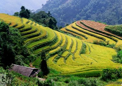
Hoang Su Phi Terraced Rice Fields, Agricultural terraces in Hoàng Su Phì, Vietnam
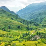
The Hoang Su Phi Terraced Rice Fields are agricultural terraces in the mountains that descend in stepped rows across multiple communes. The terraces follow the natural contours of the landscape from higher elevations down to valley areas, covering approximately 3,000 hectares.
Local ethnic communities developed these terraces over generations using traditional techniques to transform steep mountain slopes into farmland. This gradual shaping of the landscape demonstrates how people and mountains have worked together across centuries.
Twelve ethnic groups, including H'mong, Dao, and Tay peoples, farm these terraces and maintain distinct traditions visible in their daily practices and village life. Walking through the settlements, you can observe how different communities approach their work and organize their time around the agricultural calendar.
The best time to visit is September and October when the rice ripens and turns the terraces into golden steps against the mountain backdrop. During these months, walking conditions are pleasant and the light creates excellent views for photography.
The irrigation system flows naturally from upper to lower terraces without requiring pumps or modern technology. This simple method reveals how mountain farmers engineered water efficiency while respecting the natural flow of the landscape.
Location: Hoàng Su Phì
GPS coordinates: 22.69941,104.65564
Latest update: December 6, 2025 19:07
Vietnam extends more than 1,000 miles (1,600 kilometers) from mountain regions in the north to the Mekong Delta in the south, offering travelers a wide range of natural and historical sites beyond urban centers. The country includes Buddhist temples like Bai Dinh and Thien Mu Pagoda, cave systems such as Son Doong and Hang En, and rice terraces at Y Ty and Hoang Su Phi. Geographic features span from limestone formations in Ninh Binh to coastal areas at Phu Quoc and Ly Son islands, and waterfalls at Ban Gioc along the Chinese border. Historical sites document different periods of Vietnamese history. The Imperial Citadel of Thang Long in Hanoi preserves royal palace remains, while Po Nagar Cham Towers in Nha Trang date to the 7th century. My Son Sanctuary in Quang Nam holds temple ruins from the Champa civilization, and Cu Chi Tunnels near Ho Chi Minh City served as an underground network during the Vietnam War. The Mekong Delta in the south consists of waterways, floating markets and traditional villages, while Mui Ne sand dunes and Lang Co Beach present different coastal landscapes.
Fansipan
100.7 km
Bao Ha Temple
66.6 km
Ba Bể National Park
103.9 km
Hoang Lien National Park
100.7 km
Thanh Thuy border checkpoint
33.1 km
Zhou's House
148.7 km
牡宜遗址
122.8 km
Pa Uon Bridge
154.9 km
马鹿塘口岸
153.5 km
南湖瀛洲亭
148.2 km
Former Mengzi Customs House
148 km
Cốc Lếu Bridge
73.9 km
Bisezhai Railway Station
153.3 km
Faux Namti Bridge
108.9 km
Tianbao Port
33.1 km
Cát Cát waterfall
94.4 km
Pho Lu Bridge
64.6 km
Kim Thanh Bridge
75.9 km
Thác Bà Lake
114.6 km
河口海关旧址
74.2 km
蒙自玉皇阁
148.7 km
大王岩岩画
47.8 km
Ha Giang provincial museum
36.8 km
同盟会河口起义纪念馆
74.2 km
保兴桥
60.6 km
Honghe Hani and Yi Autonomous Prefecture Museum
151.1 km
Muong Hoa Valley
90.8 km
牛羊太平桥
59.2 kmVisited this place? Tap the stars to rate it and share your experience / photos with the community! Try now! You can cancel it anytime.
Discover hidden gems everywhere you go!
From secret cafés to breathtaking viewpoints, skip the crowded tourist spots and find places that match your style. Our app makes it easy with voice search, smart filtering, route optimization, and insider tips from travelers worldwide. Download now for the complete mobile experience.
A unique approach to discovering new places❞
— Le Figaro
All the places worth exploring❞
— France Info
A tailor-made excursion in just a few clicks❞
— 20 Minutes