Enable Location

We need your location to show you interesting places around you

Discover nearby places

Find interesting locations and hidden gems around you

Precise directions

Get accurate directions and distances to places

Your location is never shared with other users. It's only used when you tap the location button.

Magsapad Rock Formation

Log in to your account

Start exploring — it's free

Trusted by 62,071 travelers worldwide

Continue with Google
Continue with Apple
or

We will send you a code to connect

By continuing, you accept our Terms and Conditions and our Privacy Policy

Check your inbox

We've sent a pincode in your inbox. Please enter the code below.

Magsapad Rock Formation

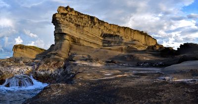
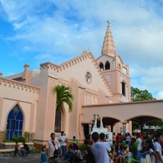
Magsapad Rock Formation, Limestone rock formation in Biri Island, Philippines.

Magsapad Rock Formation is a limestone structure along the northeastern edge of Biri Island, shaped by constant ocean wave action and wind over time. The landscape features jagged cliffs with crevices and natural basins created through the slow erosion of the stone.

The rock formation developed over thousands of years as ocean waves and wind slowly wore away layers of limestone. This ongoing process continues to reshape the structure today.

The formation is woven into the daily life of local fishing communities who use its sheltered areas and natural resources as part of their work. Residents have adapted their maritime traditions around this landscape for generations.

The best time to visit is during low tide when more of the formation is exposed and tidal pools are easier to access safely. Wear sturdy shoes since the ground is uneven and slippery, especially after rain or tidal shifts.

When high tide arrives, natural crevices and basins fill with seawater and harbor small fish and other sea creatures that visitors can watch. These temporary pools offer a rare glimpse into marine life in an isolated setting.

The community of curious travelers

AroundUs brings together thousands of curated places, local tips, and hidden gems, enriched daily by 60,000 contributors worldwide.

Start exploring
Location
Address
M9WC+63H, Biri, Northern Samar, Philippines
GPS coordinates
12.69532,124.37051
Latest update
December 6, 2025 19:07
Natural landmarks of the Philippines for photography

The Philippines display rice terraces in Ifugao mountains, coral reefs in Tubbataha National Park, and cave systems in Samar. Mayon Volcano shows its geometric shape, while Chocolate Hills of Bohol extend across the landscape. White sand beaches line the coasts of Boracay and Palawan.

« Magsapad Rock Formation - Limestone rock formation in Biri Island, Philippines » is provided by Around Us (aroundus.com). Images and texts are derived from Wikimedia project under a Creative Commons license. You are allowed to copy, distribute, and modify copies of this page, under the conditions set by the license, as long as this note is clearly visible.

Discover hidden gems everywhere you go!

From secret cafés to breathtaking viewpoints, skip the crowded tourist spots and find places that match your style. Our app makes it easy with voice search, smart filtering, route optimization, and insider tips from travelers worldwide. Download now for the complete mobile experience.

Around Us App Screenshot

A unique approach to discovering new places

Le Figaro

All the places worth exploring

France Info

A tailor-made excursion in just a few clicks

20 Minutes

Around Us
Travel Guide & Maps
Download

Send to your phone

QR Code
1

Open the camera app on your mobile.

2

Point at the QR code with your camera. A notification will appear.

3

Tap the notification to open the link.