Magasang Rock Formation

Log in to your account

AroundUs is a community-driven map of interesting places, built by curious explorers like you. It grows with every review, story, and photo you share.
Connect to save your favorite spots, contribute locations, and create personalized routes.
By continuing, you accept our Terms and Conditions and our Privacy Policy

Magasang Rock Formation

Add to collection
Map
Suggest a change
Share

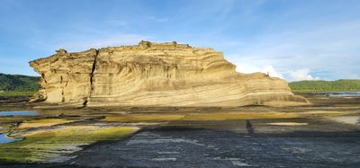
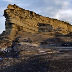
Magasang Rock Formation, Natural rock formation on Biri Island, Philippines.

Magasang Rock Formation on Biri Island consists of tall limestone cliffs marked by grooves and patterns shaped by constant wave action and wind exposure. The structure varies in height and texture, creating different sections that reveal layers of geological development along the shoreline.

The formation developed over millions of years through geological processes driven by tectonic shifts and continuous water erosion that sculpted the rock surfaces. This slow transformation represents part of the broader geological history that shaped the entire Northern Samar coastline.

Local communities view this formation as a landmark connected to their relationship with the sea and incorporate it into stories passed down through generations. The rock shapes how people navigate and understand the coastal landscape around them.

Visitors should plan their visit around low tide conditions, when more of the formation becomes accessible and safer to explore along the base. Local guides or boat operators know the best times and routes to visit and can help time your trip to the tidal cycle.

During specific tidal conditions, water collects in depressions across the rock surface, creating temporary pools nestled among the eroded stone. These fleeting water features shift and disappear with the tide cycles, offering an element many visitors overlook.

Location: Biri

GPS coordinates: 12.69676,124.36817

Latest update: December 6, 2025 19:02

Natural landmarks of the Philippines for photography

The Philippines display rice terraces in Ifugao mountains, coral reefs in Tubbataha National Park, and cave systems in Samar. Mayon Volcano shows its geometric shape, while Chocolate Hills of Bohol extend across the landscape. White sand beaches line the coasts of Boracay and Palawan.

Reviews

Visited this place? Tap the stars to rate it and share your experience / photos with the community! Try now! You can cancel it anytime.

« Magasang Rock Formation - Natural rock formation on Biri Island, Philippines » is provided by Around Us (aroundus.com). Images and texts are derived from Wikimedia project under a Creative Commons license. You are allowed to copy, distribute, and modify copies of this page, under the conditions set by the license, as long as this note is clearly visible.

Discover hidden gems everywhere you go!

From secret cafés to breathtaking viewpoints, skip the crowded tourist spots and find places that match your style. Our app makes it easy with voice search, smart filtering, route optimization, and insider tips from travelers worldwide. Download now for the complete mobile experience.

Around Us App Screenshot

A unique approach to discovering new places

Le Figaro

All the places worth exploring

France Info

A tailor-made excursion in just a few clicks

20 Minutes