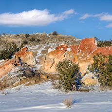
Natural Bridge
Location: Sandoval County
Operator: BLM
GPS coordinates: 35.49760,-107.18229
Latest update: November 20, 2025 13:20
Ojito Wilderness
25.9 km
Guadalupe Outlier
5.6 km
Big Bead Mesa
3.1 km
Tamayameh Kah Sta Mah
15 km
Rincon del Oso
22.8 km
Standing Rock
36.4 km
Lagunita
20.9 km
Puerto Grande
25.6 km
Laguna Techillas
44.3 km
Dos Amigos
35.7 km
Moon Rocks
36.4 km
Petroglyphs
24.6 km
(Little) Snoopy Rock
36.9 km
Crystal Hill
36.4 km
Hoodoos
23.3 km
Dragon's Back/(Big) Snoopy
36.9 km
Fossil Hill
36.3 km
Hoodoos
31.4 km
Hoodoos
23.1 km
Needalocker Hill/Bart's Rock
37 km
Rio Puerco Rock Formations
34.1 km
The Canyon
36.6 km
The Wall
35.4 km
White Mesa
31.5 km
Ojito Wilderness Overlook
23 km
Mesa Overlook
37.1 km
Rio Rancho Badlands Overlook
28.4 km
Thunderdome
32.9 kmReviews
Visited this place? Tap the stars to rate it and share your experience / photos with the community! Try now! You can cancel it anytime.
Discover hidden gems everywhere you go!
From secret cafés to breathtaking viewpoints, skip the crowded tourist spots and find places that match your style. Our app makes it easy with voice search, smart filtering, route optimization, and insider tips from travelers worldwide. Download now for the complete mobile experience.

A unique approach to discovering new places❞
— Le Figaro
All the places worth exploring❞
— France Info
A tailor-made excursion in just a few clicks❞
— 20 Minutes