Chest opened
+${chestReward.xp} XP
Explorer
NOUVEAU ×${chestReward.collectible.quantity}
tapez pour fermer
Chest locked

Open chests in the app

Around Us is built for your phone — chests unlock when you walk, explore and capture nearby places.

Enable Location

We need your location to show you interesting places around you

Discover nearby places

Find interesting locations and hidden gems around you

Precise directions

Get accurate directions and distances to places

Your location is never shared with other users. It's only used when you tap the location button.

Little Missouri Falls

Log in to your account

Start exploring — it's free

Trusted by 73,038 travelers worldwide

Continue with Google
Continue with Apple
or

We will send you a code to connect

By continuing, you accept our Terms and Conditions and our Privacy Policy

Check your inbox

We've sent a pincode in your inbox. Please enter the code below.

Little Missouri Falls
Discussion Reviews 1 Photos
600+ Popularity

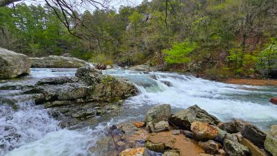
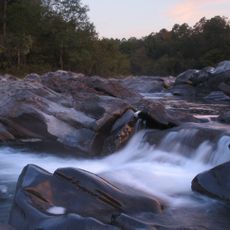
Little Missouri Falls, Waterfall in Montgomery County, Arkansas, United States.

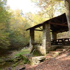
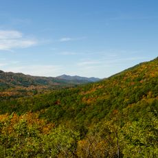
Little Missouri Falls features multiple cascading waterfalls that descend into small pools along the Little Missouri River within the Ouachita National Forest, creating natural swimming areas surrounded by forested terrain and rocky formations.

Archaeological excavations at Little Missouri Falls have revealed a campsite dating back approximately 7,000 years to the Archaic period, where prehistoric hunter-gatherers crafted tools from novaculite and established temporary camps for hunting and resource gathering.

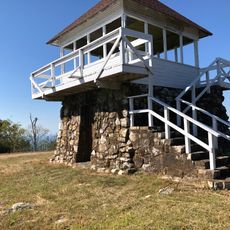
The falls serve as part of Arkansas's network of natural attractions within the National Wild and Scenic River system, promoting outdoor recreation traditions including hiking, swimming, fishing, and wildlife observation in the Ouachita Mountains region.

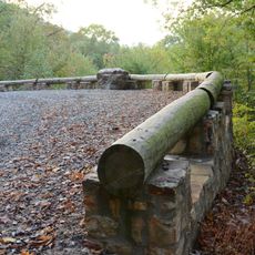
Access to Little Missouri Falls requires driving from Norman, Arkansas via Highway 8 West followed by approximately three miles on gravel roads FR# 43 and Crooked Creek Road, with facilities including picnic tables, BBQ grills, and vault toilets.

The site contains novaculite quarries that are geologically distinctive to the south Ouachita Mountains, providing raw materials that prehistoric inhabitants used to create specialized stone tools and spear points found nowhere else in the region.

The community of curious travelers

AroundUs brings together thousands of curated places, local tips, and hidden gems, enriched daily by 60,000 contributors worldwide.

Start exploring
Address
AR-369, Langley, AR 71952, USA
Phone
GPS coordinates
34.42138,-93.91864
Latest update
October 7, 2025 08:28
Around this place
Cossatot River State Park-Natural Area
United States of America

Cossatot River State Park-Natural Area

26.9 km
Shady Lake Recreation Area
United States of America

Shady Lake Recreation Area

12.3 km
Ebenezer Campground
United States of America

Ebenezer Campground

40.9 km
Huddleston Store and McKinzie Store
United States of America

Huddleston Store and McKinzie Store

18.1 km
Mountain Fork Bridge
United States of America

Mountain Fork Bridge

45.7 km
Ebenezer Monument
United States of America

Ebenezer Monument

34.8 km
Bard Springs Bathhouse
United States of America

Bard Springs Bathhouse

9.1 km
Mena City Hall
United States of America

Mena City Hall

34.5 km
Tall Peak Fire Tower
United States of America

Tall Peak Fire Tower

12 km
Janssen Park
United States of America

Janssen Park

34.6 km
Old Bank of Amity
United States of America

Old Bank of Amity

45.5 km
Collier Springs Picnic Area
United States of America

Collier Springs Picnic Area

30.7 km
Old Corinth Cemetery
United States of America

Old Corinth Cemetery

42.6 km
Hale Creek Bridge
United States of America

Hale Creek Bridge

45.3 km
Montgomery County Courthouse
United States of America

Montgomery County Courthouse

30.4 km
Crystal Campground
United States of America

Crystal Campground

26.6 km
Polk County Courthouse
United States of America

Polk County Courthouse

34.7 km
Conway Hotel
United States of America

Conway Hotel

45.7 km
Self Creek Bridge
United States of America

Self Creek Bridge

25.4 km
Judge Benjamin Shaver House
United States of America

Judge Benjamin Shaver House

34.9 km
Caddo Valley Academy Complex
United States of America

Caddo Valley Academy Complex

22.3 km
Elks Lodge
United States of America

Elks Lodge

34.5 km
Buckeye Vista Overlook
United States of America

Buckeye Vista Overlook

10.6 km
Mena Commercial Historic District
United States of America

Mena Commercial Historic District

34.2 km
Sugar Creek Vista Overlook
United States of America

Sugar Creek Vista Overlook

12.6 km
Parks School
United States of America

Parks School

42.7 km
Norman Town Square
United States of America

Norman Town Square

22.2 km
Pike County Courthouse
United States of America

Pike County Courthouse

45.2 km
Show the full map
Reviews
Share your experience

No review yet

Discussions
Start a discussion...

No discussion yet

« Little Missouri Falls - Waterfall in Montgomery County, Arkansas, United States » is provided by Around Us (aroundus.com). Images and texts are derived from Wikimedia project under a Creative Commons license. You are allowed to copy, distribute, and modify copies of this page, under the conditions set by the license, as long as this note is clearly visible.

Discover hidden gems everywhere you go!

From secret cafés to breathtaking viewpoints, skip the crowded tourist spots and find places that match your style. Our app makes it easy with voice search, smart filtering, route optimization, and insider tips from travelers worldwide. Download now for the complete mobile experience.

Around Us App Screenshot

A unique approach to discovering new places

Le Figaro

All the places worth exploring

France Info

A tailor-made excursion in just a few clicks

20 Minutes

Around Us
Travel Guide & Maps
Download

Send to your phone

QR Code
1

Open the camera app on your mobile.

2

Point at the QR code with your camera. A notification will appear.

3

Tap the notification to open the link.