Enable Location

We need your location to show you interesting places around you

Discover nearby places

Find interesting locations and hidden gems around you

Precise directions

Get accurate directions and distances to places

Your location is never shared with other users. It's only used when you tap the location button.

Hooker Valley Track

Log in to your account

Start exploring — it's free

Trusted by 61,409 travelers worldwide

Continue with Google
Continue with Apple
or

We will send you a code to connect

By continuing, you accept our Terms and Conditions and our Privacy Policy

Check your inbox

We've sent a pincode in your inbox. Please enter the code below.

Hooker Valley Track

Hooker Valley Track

Description

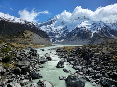
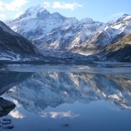
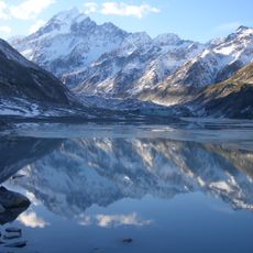
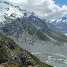
The Hooker Valley Track is a walking route in the Mackenzie District that runs through a flat valley with mountain views and covers about 10 kilometers round trip. The path follows firm clay and gravel surfaces and crosses three swing bridges spanning rivers and glacial streams before reaching a viewpoint overlooking the glacier lake.

History

The route was created to give visitors safe and easy access to the glaciers and mountain landscape around Mount Cook, which has been a climbing destination for over a century. The valley itself was carved by glaciers over millions of years, shaping the landscape visible today.

Culture

The Hooker Valley Track provides access to a protected landscape where visitors encounter native plants and wildlife in their natural setting. The valley draws people from many countries seeking to connect with the mountain environment, and encounters with curious kea birds at the lake are a common highlight.

Practical

The starting point is the White Horse Hill Campground with parking at the valley entrance, where parking fees apply from mid-December through June. The trail has partial wheelchair accessibility with firm surfaces suitable for wheelchairs and strollers in early sections, but visitors should prepare for rapidly changing mountain weather and bring appropriate clothing.

Did you know?

The bridges crossing the valley are currently being rebuilt after water damage to older structures, limiting visitors to a specific viewpoint for now. This ongoing construction offers a rare glimpse into the maintenance work needed to preserve access to this alpine environment.

Address
Hooker Valley Track, Mt Cook National Park 7999, New Zealand
GPS coordinates
-43.71100,170.09525
Latest update
January 30, 2026 12:22

AroundUs brings together thousands of curated places, local tips, and hidden gems, enriched daily by 60,000 contributors worldwide. Discover all places nearby (Mackenzie District).

South Island New Zealand: fjords, glaciers, vineyards

New Zealand's South Island has many places that show the variety of this region in the South Pacific. The landscapes range from the deep fjords of Milford Sound to the glaciers of Fox and Franz Josef, from the snowy peaks of Aoraki/Mount Cook to the golden beaches of Abel Tasman. Towns like...

« Hooker Valley Track » is provided by Around Us (aroundus.com). Images and texts are derived from Wikimedia project under a Creative Commons license. You are allowed to copy, distribute, and modify copies of this page, under the conditions set by the license, as long as this note is clearly visible.

Discover hidden gems everywhere you go!

From secret cafés to breathtaking viewpoints, skip the crowded tourist spots and find places that match your style. Our app makes it easy with voice search, smart filtering, route optimization, and insider tips from travelers worldwide. Download now for the complete mobile experience.

Around Us App Screenshot

A unique approach to discovering new places

Le Figaro

All the places worth exploring

France Info

A tailor-made excursion in just a few clicks

20 Minutes

Around Us
Travel Guide & Maps
Download

Send to your phone

QR Code
1

Open the camera app on your mobile.

2

Point at the QR code with your camera. A notification will appear.

3

Tap the notification to open the link.