See the monuments around you in AROpen chests in the app
Around Us is built for your phone — point your camera at the streets and discover the monuments and places around you in augmented reality.Around Us is built for your phone — chests unlock when you walk, explore and capture nearby places.
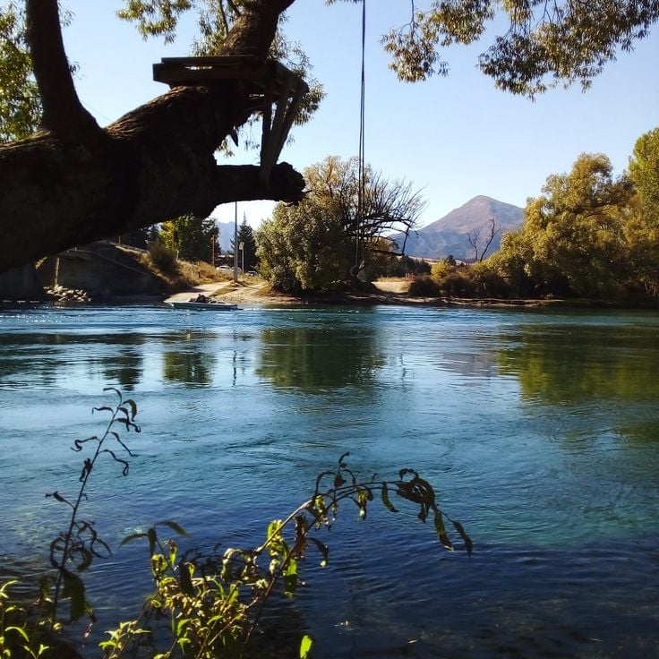
Fjords, glaciers, and wine regions shape New Zealand's South Island into a land of dramatic contrasts and endless exploration.
New Zealand's South Island is a place where you can move from one kind of landscape to another within hours. You might wake up looking at deep fjords with water so dark it mirrors the sky, then drive to glaciers where ice flows down from mountains, then climb to the snowy peaks of Aoraki/Mount Cook, or walk along the golden beaches of Abel Tasman. Towns like Queenstown, Christchurch, and Dunedin sit at the edge of these natural areas and work as good starting points for exploring. The vineyards around Central Otago grow grapes that wine drinkers recognize worldwide.
In the southwest, four national parks sit within the UNESCO World Heritage area called Te Wahipounamu. When you walk through these parks, you pass through old forests, see high mountain lakes, walk past waterfalls, and follow paths that cut through valleys carved long ago by glaciers. Maori cultural sites mark the land and tell you about the tangata whenua, the first people to make their homes here. Whether you stand alone on a quiet mountain lake or walk through a busy city center, each place shows you something different about what the South Island holds.
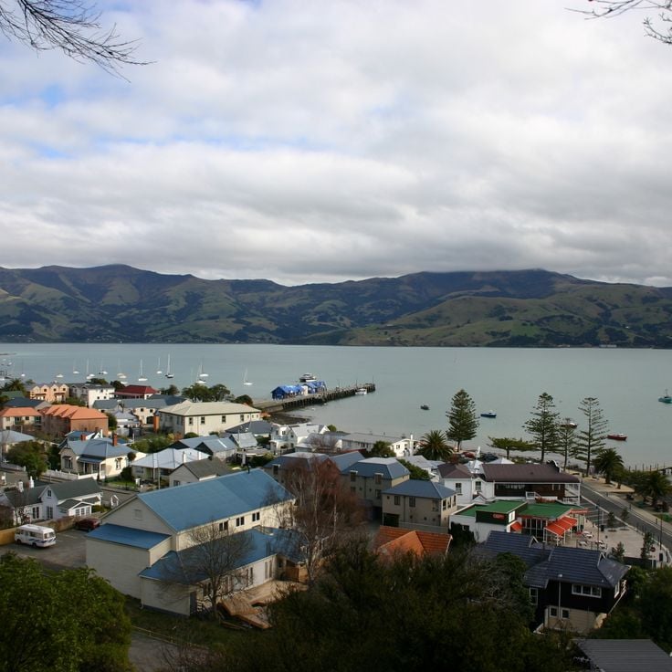
Akaroa is a small coastal village on Banks Peninsula, shaped by its French past. Colorful wooden houses, narrow streets, and restaurants overlooking the harbor still carry the memory of the first European settlers. Walking through the village gives a sense of a different side of New Zealand, far from the busy city centers. The surrounding peninsula offers rugged cliffs, green hills, and sheltered bays.
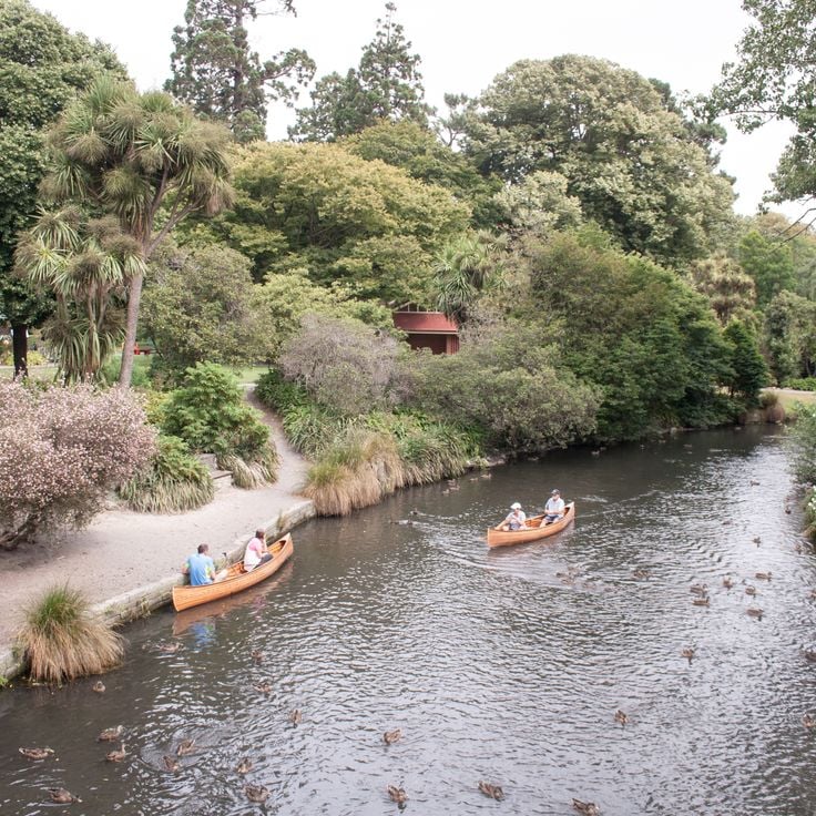
The Christchurch Botanic Gardens sit inside Hagley Park, a large green space at the heart of the city. Plants from New Zealand and from many parts of the world grow side by side here. Walking paths lead through formal gardens, open meadows, and wooded sections. The seasons show clearly as flowers bloom and trees change throughout the year, making each visit feel a little different from the last.
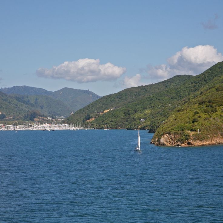
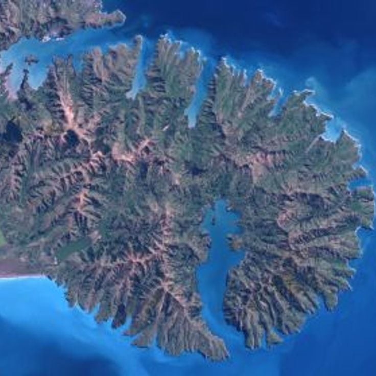
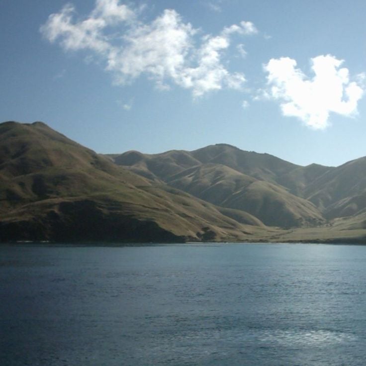
Queen Charlotte Sound is a winding network of bays, islands, and coastal waterways in the Marlborough region at the northern tip of New Zealand's South Island. The Sounds formed when river valleys sank into the sea, creating a mix of calm water and forested hills. Visitors come to kayak, sail, or walk the Queen Charlotte Track, a coastal trail that follows the water's edge with open views across the Sound. Small harbors, mussel-farming boats, and the slow rhythm of life on the water define the feel of this place. It sits apart from the busier towns of the South Island, offering a different pace.
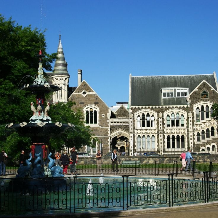
Christchurch sits on the east coast of the South Island and is a city in the middle of change. After a major earthquake, much of the center was rebuilt, and today modern buildings stand next to older structures that still carry the memory of what came before. The streets are easy to walk, with art galleries, museums, and open spaces that reflect daily city life. For those exploring the South Island, Christchurch makes a natural starting point for journeys further south or west.
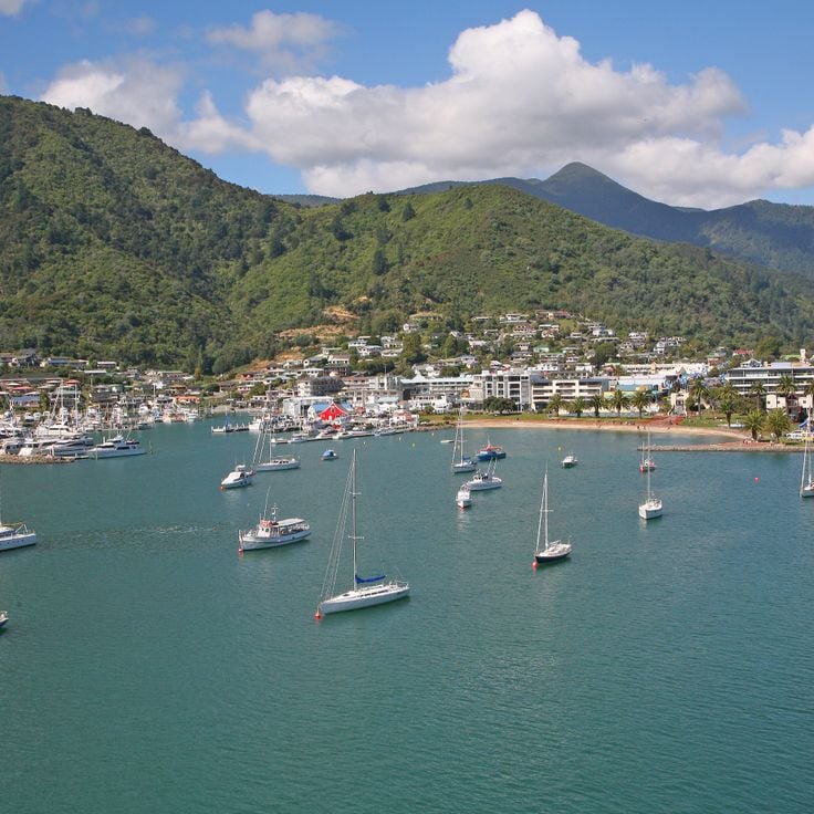
Picton is a harbor town on the northern coast of the South Island and the main starting point for the Marlborough Sounds. Regular ferries connect it to the North Island, making it a natural crossing point. From here, travelers can explore the winding waterways, dense forests, and sheltered bays of the Marlborough Sounds. The town has restaurants, shops, and places to stay for those passing through or preparing for longer trips.
Banks Peninsula is a volcanic headland east of Christchurch, shaped by old eruptions that formed deep harbors and rolling green hills. Along the South Island's east coast, it stands apart from the glaciers and fjords further west. Small villages like Akaroa sit tucked into sheltered bays. Walking trails cross the hills above the sea. The waters around the peninsula are home to dolphins and seals, which can be seen on short boat trips from the shore.
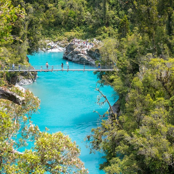
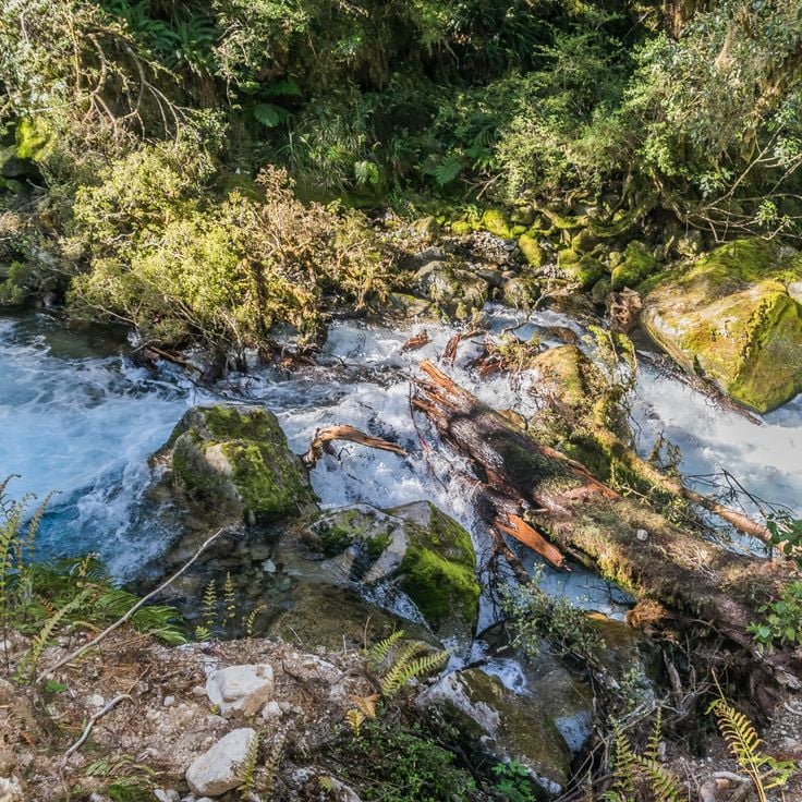
Hokitika Gorge cuts through the West Coast of New Zealand's South Island, where a river runs between tall rock walls over bright blue-green water. A swing bridge crosses the gorge and gives a close view of the river below. The surrounding forest is dense and the rock faces drop steeply into the water. This spot fits naturally into a journey across the South Island, sitting between the glaciers to the north and the fjords further south.
The Marlborough District sits in the northern part of the South Island and is known around the world for its Sauvignon Blanc. Rolling hills and flat valleys are covered with grapevines as far as the eye can see. Blenheim, the main town, is a good base for visiting the many wineries and trying local food. Walking or driving through the vineyards gives a real sense of why this corner of the South Island draws so many wine lovers.
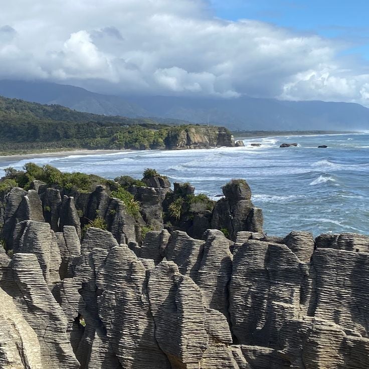
The Punakaiki Pancake Rocks and Blowholes Walk takes you along the west coast of the South Island to a formation of layered rock that looks like stacked pancakes. At high tide, seawater pushes into underground caverns and shoots upward through cracks in the rock. The path runs along the clifftops, with open views over the Tasman Sea. The best time to visit is when the tide is high and the water jets are in full force.
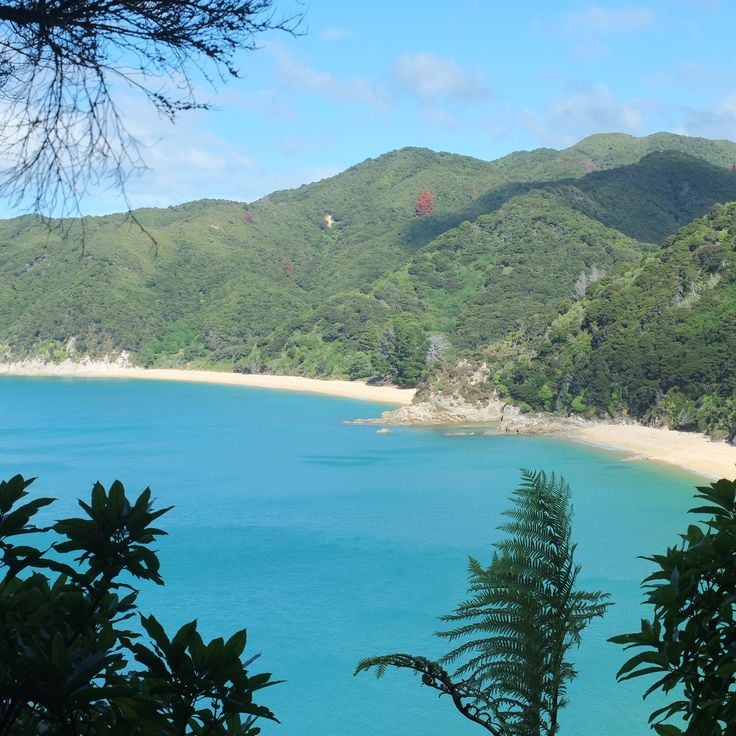
Abel Tasman National Park sits on the northwest coast of New Zealand's South Island and stands out as one of the most inviting stops in this collection. Golden beaches meet dense forest, and the water shifts through many shades of blue. Visitors can paddle by kayak along the shoreline, weaving between islands and stopping in sheltered bays. Walking trails wind through rainforest past tall trees and ferns. Seals and seabirds are common here. Small villages nearby offer places to stay and eat.
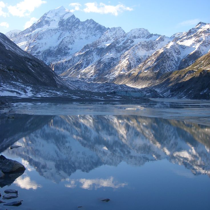
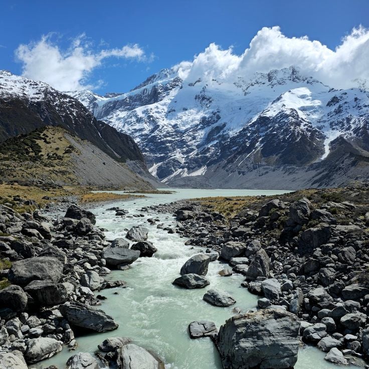
The Hooker Valley Track runs through the heart of Aoraki/Mount Cook National Park in the Canterbury region. The path follows glacial lakes and offers direct views of New Zealand's highest peak. The landscape shows how glaciers have shaped the valley over thousands of years. Swing bridges cross rivers fed by milky blue glacial water. This track is one of the most visited walking routes on the South Island, and it gives a strong sense of the mountain forces that define this part of New Zealand.
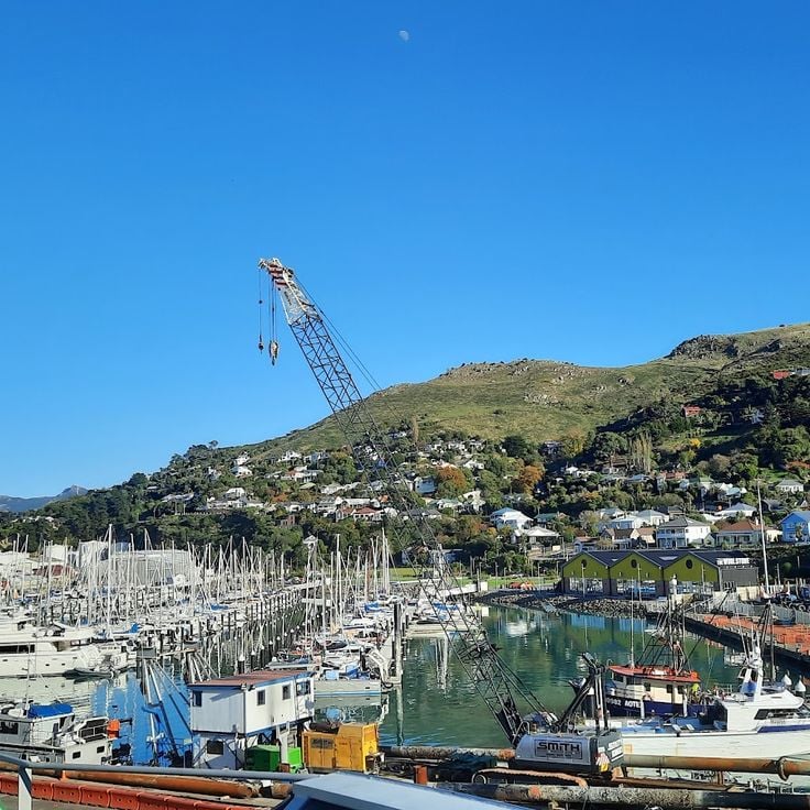
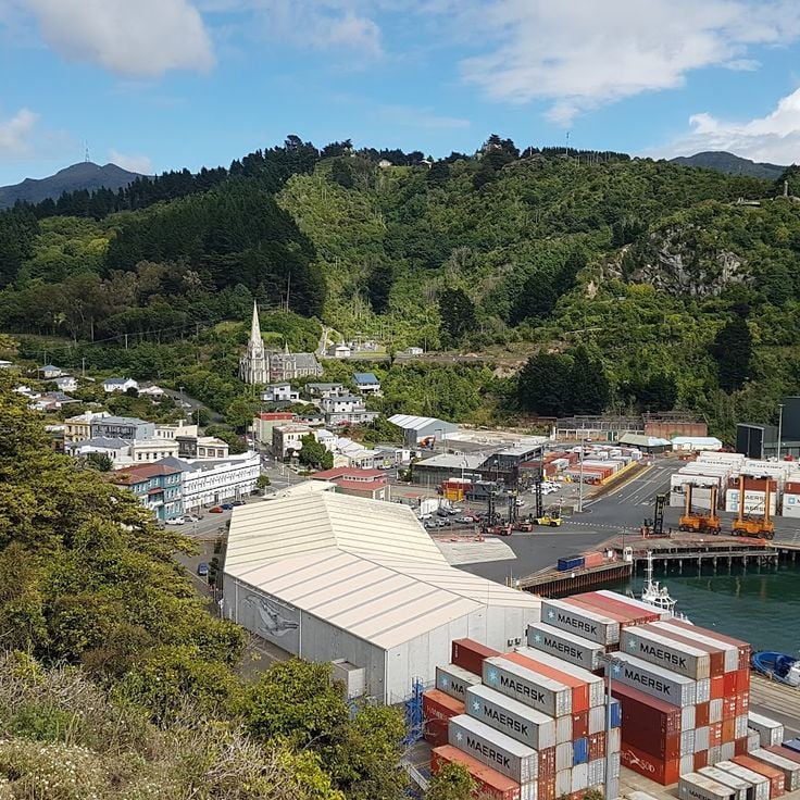
Lyttelton Port sits inside a deep natural harbour in the hills just outside Christchurch. This is where the city has long met the sea. Along the waterfront, you can watch cargo ships come and go, follow small boats out toward the bay, and walk through an old port neighborhood that still carries the feel of working maritime life. The port gives a clear sense of how Christchurch has depended on the sea for generations, and it makes a natural stop when exploring the South Island's coast.
Nelson Lakes National Park sits in the Nelson Mountains in the northern part of the South Island, away from the busier spots further south. Two large alpine lakes, Lake Rotoiti and Lake Rotoroa, sit at the heart of the park, surrounded by forested hillsides. The forests are home to trees found only in New Zealand. Trails lead up into the mountains and out to remote huts. Birds like the kea and the fantail are easy to spot along the paths. For travelers exploring the South Island, the park offers a chance to walk through native bush and spend time beside still mountain water.
Kaikōura sits on the east coast of the South Island, squeezed between the ocean and a mountain range. The town is known above all for its marine mammals: sperm whales surface regularly offshore, and boat trips bring visitors close to dolphins and sea lions. For those who prefer to stay on land, coastal walking tracks run along the water's edge. Kaikōura makes a good base for anyone wanting to experience the marine life along this stretch of New Zealand's South Island.
Nelson sits at the northwest tip of the South Island and enjoys more sunny days than almost anywhere else in New Zealand. The town has drawn artists and craftspeople over the years, and their galleries and studios are scattered throughout the streets. A local market brings together fresh regional produce and handmade goods. From Nelson, it is easy to reach Abel Tasman National Park, with its sheltered bays and sandy beaches. The town works well as a base for hiking and kayaking into the natural areas that surround it.
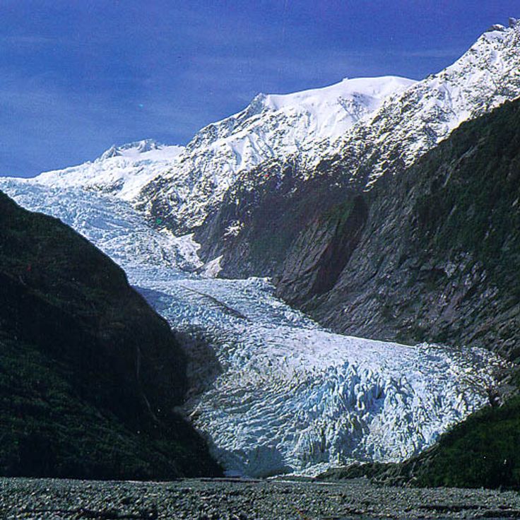
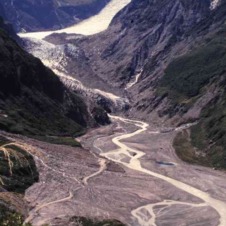
Franz Josef Glacier sits on the west coast of the South Island and is one of New Zealand's most visited glaciers. The ice flows down from the mountains into a valley framed by steep rock walls, which have been shaped over thousands of years by the movement of the ice. Visitors can walk through the glacier valley on several trails, from short and easy paths to longer and more demanding hikes. On clear days, the surrounding mountain peaks come into full view.
Fox Glacier sits on the west coast of the South Island and is one of New Zealand's most active glaciers. The ice moves slowly and changes shape as it goes. Visitors can walk on the glacier itself and look out at the snow-covered peaks nearby. The surrounding forests receive frequent rain, which feeds the ice, and create a sharp contrast with the frozen mass above.
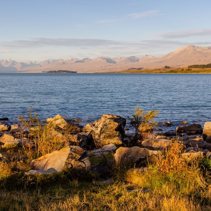
Lake Tekapo is an alpine lake in the Canterbury region of New Zealand's South Island. Its water takes on a milky blue color from glacial silt carried down from the surrounding mountains. The skies above this lake are among the darkest in the country, making it a popular stop for stargazing. Walking paths run along the shore, and a small village sits nearby. Many travelers pause here on their way to the glaciers and mountain ranges that define this part of the South Island.
Lake Pukaki is an alpine lake in the Canterbury region, sitting at the foot of Aoraki/Mount Cook, New Zealand's tallest mountain. The water carries a deep turquoise color from glacial meltwater, which makes the views from the shore easy to remember. Many travelers stop here on their way toward the glaciers and mountain trails further south. Standing at the lake's edge, you can take in the full scale of the peaks rising above and understand why this part of the South Island draws so many visitors.
Wānaka sits on the shore of a large lake in the Otago region, offering a relaxed starting point for walks into the surrounding mountains and glacier-carved valleys. The town is noticeably quieter than other centers on the South Island, such as Queenstown, making it a good base for those who want to explore the lakes, forests, and high country trails of this part of New Zealand.
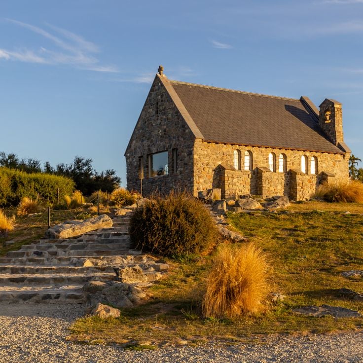
The Church of the Good Shepherd is a small chapel sitting on the shore of Lake Tekapo in Canterbury. It was built to honor the shepherds who once worked across this part of the South Island. Looking through its stone windows, you see the snow-covered peaks and the blue-green waters of the lake. A cemetery sits beside the chapel. The place connects the history of early European settlement in New Zealand with the open sky and mountain scenery of the Mackenzie Basin.
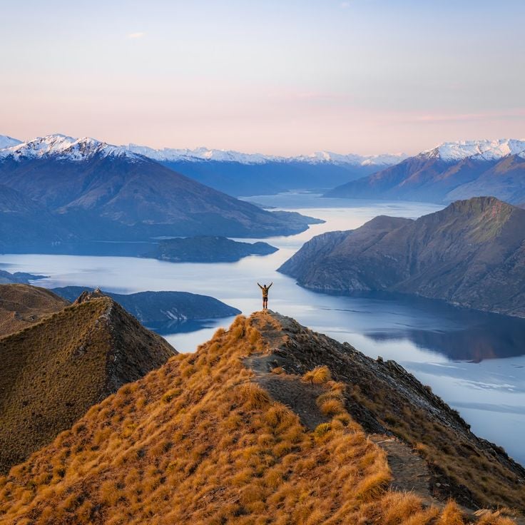
Roys Peak Track is a hiking route in Otago that climbs to a high summit above Lake Wanaka. From the top, you can see the lake spread out below and the mountains rising around it. The walk is long and steep, but it gives a strong sense of how the South Island looks from above.
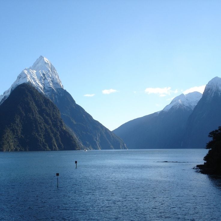
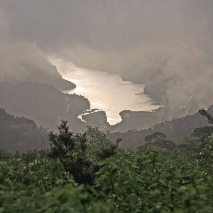
Milford Sound / Piopiotahi is a fjord in Southland where steep cliffs rise directly from deep water. Visitors travel by boat through the fjord and pass several waterfalls that fall down the rock faces into the water below. Rainforests cover the slopes, and the mountains drop sharply into the water. This fjord is part of the UNESCO World Heritage site Te Wahipounamu and shows the raw power of New Zealand's South Island.
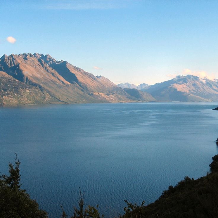
The Queenstown-Lakes District sits on the shores of Lake Wakatipu and is the adventure hub of New Zealand's South Island. Hiking in the mountains, river rafting, paragliding over the hills, and jetboat rides on the lake are part of everyday life here. In the evening, the town's restaurants, bars, and clubs fill with people. This district is also a natural base for trips to the fjords of Milford Sound and other places across the South Island.
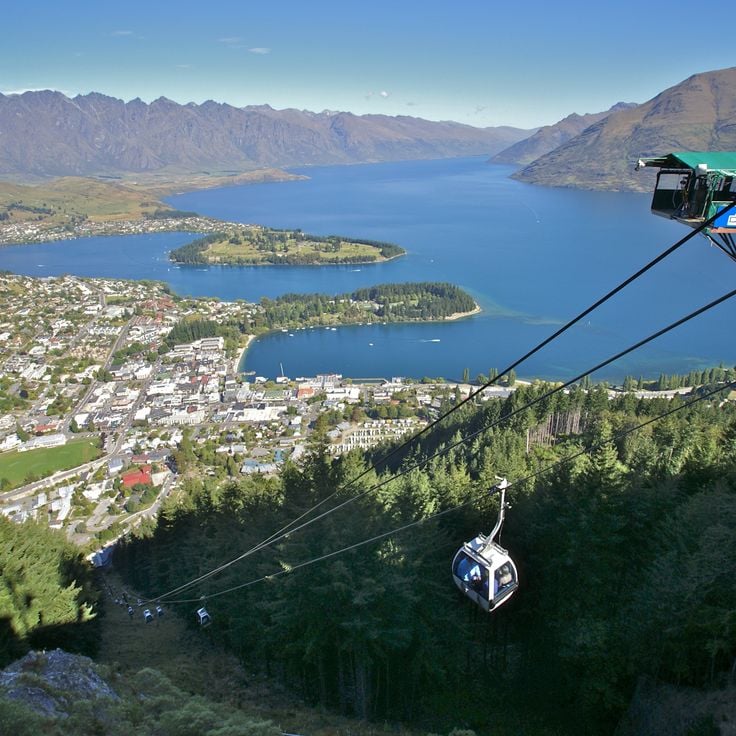
Skyline Queenstown is a gondola that carries you from the city center up to a mountain above the town. From the top, you see Queenstown spread below, the waters of Lake Wakatipu, and the Remarkables mountains rising in the distance. The summit has restaurants, a café, and walking paths. You can also ride down on bobsled tracks or simply take in the view. In the evening, when the city lights come on, the view takes on a whole new feel.
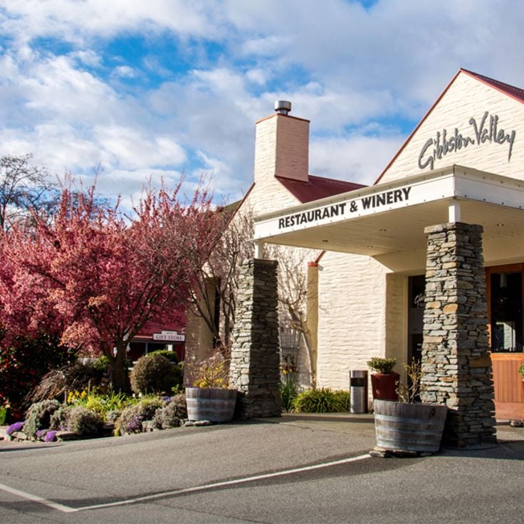
Gibbston Valley Wines sits in the heart of Central Otago, one of the southernmost wine regions in the world. The vines grow in a narrow valley framed by rocky slopes and dry grassland, giving the wines a character tied to the local soil and climate. Visitors can walk through the vineyards, join tastings, and learn how winemaking works in this high-country setting. The Pinot Noir produced here is recognized well beyond New Zealand.
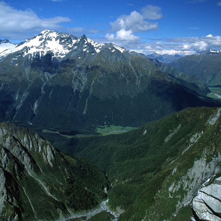
Mount Aspiring National Park sits in western Otago and is part of the UNESCO World Heritage site Te Wahipounamu. The park covers alpine valleys, mountain ridges, and deep gorges carved by rivers and glaciers. Walking tracks cross old forests and open highland areas where rare birds such as the kea make their home. For travelers exploring the South Island's interior, this park is a natural gateway into the heart of the region.
Doubtful Sound / Patea is a fjord in Southland that takes more effort to reach than Milford Sound. You cross Lake Manapouri by boat, then travel over a mountain pass before arriving at the water. The fjord runs deep and dark, with steep rock walls dropping straight into the sea on both sides. Waterfalls pour down from the cliffs after rain. Dolphins, seals, and penguins live here year-round. The whole area is part of Te Wahipounamu, a UNESCO World Heritage site that covers much of the southwest of the South Island.
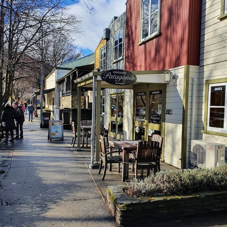
Arrowtown is a small historic village in the Otago region, shaped by the gold rush of the 19th century. The main street is lined with old buildings, many of which still house shops and restaurants. In autumn, the surrounding mountains turn warm shades of red and gold. Sitting in a valley close to Queenstown, Arrowtown offers a window into the lives of the gold seekers who once settled here, making it a natural stop on any South Island journey.
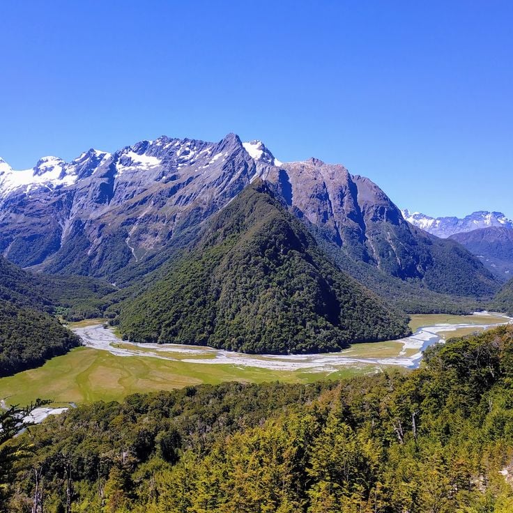
Fiordland National Park sits at the heart of Te Wahipounamu, a UNESCO World Heritage Site on New Zealand's South Island. The park is home to Milford Sound and Doubtful Sound, where steep rock faces drop straight into dark water and waterfalls run down the cliffs after rain. Old forests cover the valley floors, and mountain lakes sit quietly between the peaks. The terrain was shaped by glaciers over thousands of years. The climate here is wet and raw, which keeps the fjords looking the way they do. Walkers can follow trails deep into valleys that few people reach.
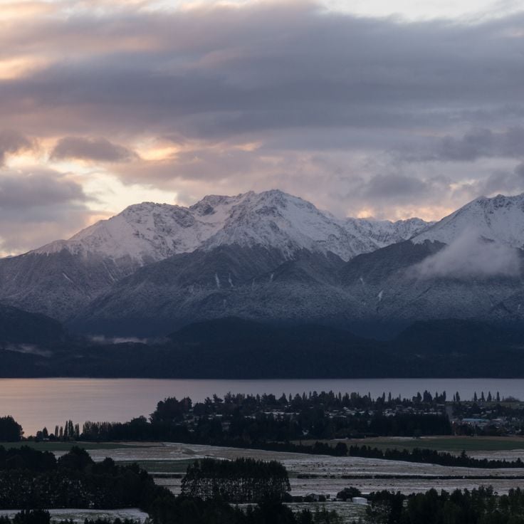
Te Anau sits on the shore of a large lake in the Southland region and is the main base for visiting Fiordland National Park. The village is close to Milford Sound and other fjords, which are among the most visited destinations on the South Island. From here, day trips head into the surrounding mountains, forests, and lakes shaped by glaciers. Nearby, the Glowworm Caves draw visitors to their glowing underground chambers. Te Anau itself has restaurants, lodging, and information centers for travelers who want to explore the wild landscape of southwestern New Zealand.
Dunedin sits on the east coast of the South Island and is known for its Victorian buildings that shape the city center. Wide streets pass museums, galleries, and old pubs. The city sits close to a stretch of coastline where penguins and seals can be spotted in the wild. For those exploring the South Island, Dunedin offers a slower pace and the feel of a working harbor town with real character.
The Routeburn Nature Walk follows one of New Zealand's most recognized hiking routes, connecting the Queenstown area with Fiordland. The track moves through alpine terrain with sharp peaks, deep lakes, waterfalls, and rainforests. Walkers cross open ridges with wide views over valleys carved by glaciers over time. This trail is part of the UNESCO World Heritage site Te Wahipounamu, central to exploring the South Island.
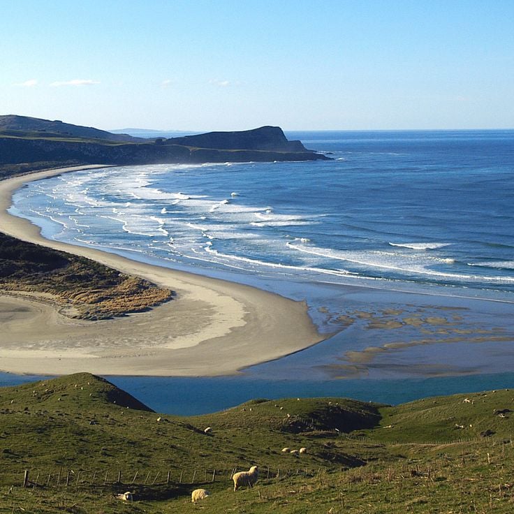
The Otago Peninsula juts out east of Dunedin into the Pacific and is one of the few places in the world where royal albatrosses nest on a mainland. Yellow-eyed penguins and New Zealand sea lions also live along this coast, on beaches sheltered by high cliffs and rocky headlands. Walking paths cross open grassland and follow cliff edges with wide views of the sea. For anyone traveling the South Island, this peninsula offers a close look at wildlife that is rarely seen anywhere else.
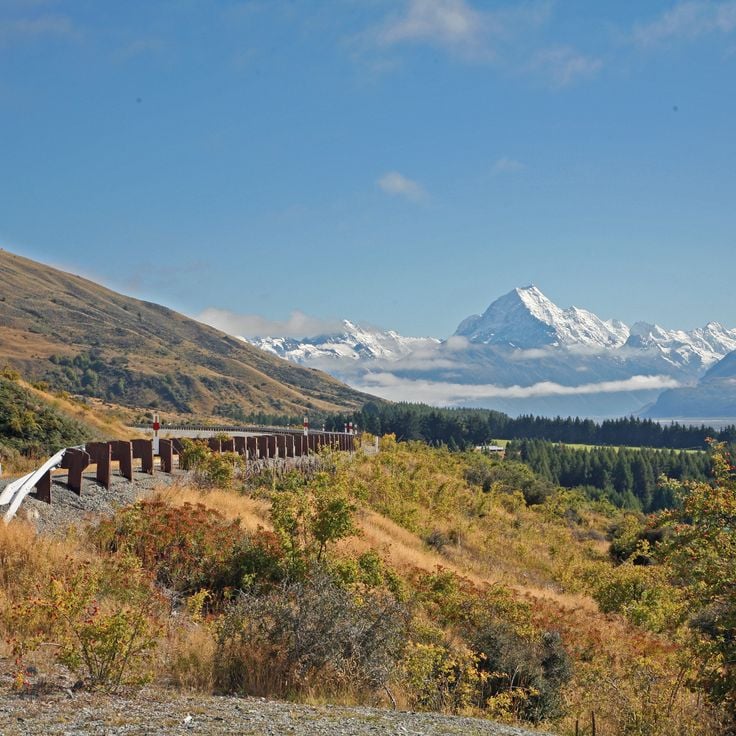
Aoraki/Mount Cook National Park sits in the Southern Alps, in the heart of New Zealand's South Island. The country's highest peak rises above a world of glaciers, rocky valleys, and mountain lakes. The Tasman Glacier runs through the park and shapes much of the terrain. Walking tracks range from short paths near the village to long routes that take several days. The park is part of the UNESCO World Heritage site Te Wahipounamu, shared with other protected areas in the southwest.
Akaroa is a small coastal village on Banks Peninsula, shaped by its French past. Colorful wooden houses, narrow streets, and restaurants overlooking the harbor still carry the memory of the first European settlers. Walking through the village gives a sense of a different side of New Zealand, far from the busy city centers. The surrounding peninsula offers rugged cliffs, green hills, and sheltered bays.
The Christchurch Botanic Gardens sit inside Hagley Park, a large green space at the heart of the city. Plants from New Zealand and from many parts of the world grow side by side here. Walking paths lead through formal gardens, open meadows, and wooded sections. The seasons show clearly as flowers bloom and trees change throughout the year, making each visit feel a little different from the last.
Queen Charlotte Sound is a winding network of bays, islands, and coastal waterways in the Marlborough region at the northern tip of New Zealand's South Island. The Sounds formed when river valleys sank into the sea, creating a mix of calm water and forested hills. Visitors come to kayak, sail, or walk the Queen Charlotte Track, a coastal trail that follows the water's edge with open views across the Sound. Small harbors, mussel-farming boats, and the slow rhythm of life on the water define the feel of this place. It sits apart from the busier towns of the South Island, offering a different pace.
Christchurch sits on the east coast of the South Island and is a city in the middle of change. After a major earthquake, much of the center was rebuilt, and today modern buildings stand next to older structures that still carry the memory of what came before. The streets are easy to walk, with art galleries, museums, and open spaces that reflect daily city life. For those exploring the South Island, Christchurch makes a natural starting point for journeys further south or west.
Picton is a harbor town on the northern coast of the South Island and the main starting point for the Marlborough Sounds. Regular ferries connect it to the North Island, making it a natural crossing point. From here, travelers can explore the winding waterways, dense forests, and sheltered bays of the Marlborough Sounds. The town has restaurants, shops, and places to stay for those passing through or preparing for longer trips.
Banks Peninsula is a volcanic headland east of Christchurch, shaped by old eruptions that formed deep harbors and rolling green hills. Along the South Island's east coast, it stands apart from the glaciers and fjords further west. Small villages like Akaroa sit tucked into sheltered bays. Walking trails cross the hills above the sea. The waters around the peninsula are home to dolphins and seals, which can be seen on short boat trips from the shore.
Hokitika Gorge cuts through the West Coast of New Zealand's South Island, where a river runs between tall rock walls over bright blue-green water. A swing bridge crosses the gorge and gives a close view of the river below. The surrounding forest is dense and the rock faces drop steeply into the water. This spot fits naturally into a journey across the South Island, sitting between the glaciers to the north and the fjords further south.
The Marlborough District sits in the northern part of the South Island and is known around the world for its Sauvignon Blanc. Rolling hills and flat valleys are covered with grapevines as far as the eye can see. Blenheim, the main town, is a good base for visiting the many wineries and trying local food. Walking or driving through the vineyards gives a real sense of why this corner of the South Island draws so many wine lovers.
The Punakaiki Pancake Rocks and Blowholes Walk takes you along the west coast of the South Island to a formation of layered rock that looks like stacked pancakes. At high tide, seawater pushes into underground caverns and shoots upward through cracks in the rock. The path runs along the clifftops, with open views over the Tasman Sea. The best time to visit is when the tide is high and the water jets are in full force.
Abel Tasman National Park sits on the northwest coast of New Zealand's South Island and stands out as one of the most inviting stops in this collection. Golden beaches meet dense forest, and the water shifts through many shades of blue. Visitors can paddle by kayak along the shoreline, weaving between islands and stopping in sheltered bays. Walking trails wind through rainforest past tall trees and ferns. Seals and seabirds are common here. Small villages nearby offer places to stay and eat.
The Hooker Valley Track runs through the heart of Aoraki/Mount Cook National Park in the Canterbury region. The path follows glacial lakes and offers direct views of New Zealand's highest peak. The landscape shows how glaciers have shaped the valley over thousands of years. Swing bridges cross rivers fed by milky blue glacial water. This track is one of the most visited walking routes on the South Island, and it gives a strong sense of the mountain forces that define this part of New Zealand.
Lyttelton Port sits inside a deep natural harbour in the hills just outside Christchurch. This is where the city has long met the sea. Along the waterfront, you can watch cargo ships come and go, follow small boats out toward the bay, and walk through an old port neighborhood that still carries the feel of working maritime life. The port gives a clear sense of how Christchurch has depended on the sea for generations, and it makes a natural stop when exploring the South Island's coast.
Nelson Lakes National Park sits in the Nelson Mountains in the northern part of the South Island, away from the busier spots further south. Two large alpine lakes, Lake Rotoiti and Lake Rotoroa, sit at the heart of the park, surrounded by forested hillsides. The forests are home to trees found only in New Zealand. Trails lead up into the mountains and out to remote huts. Birds like the kea and the fantail are easy to spot along the paths. For travelers exploring the South Island, the park offers a chance to walk through native bush and spend time beside still mountain water.
Kaikōura sits on the east coast of the South Island, squeezed between the ocean and a mountain range. The town is known above all for its marine mammals: sperm whales surface regularly offshore, and boat trips bring visitors close to dolphins and sea lions. For those who prefer to stay on land, coastal walking tracks run along the water's edge. Kaikōura makes a good base for anyone wanting to experience the marine life along this stretch of New Zealand's South Island.
Nelson sits at the northwest tip of the South Island and enjoys more sunny days than almost anywhere else in New Zealand. The town has drawn artists and craftspeople over the years, and their galleries and studios are scattered throughout the streets. A local market brings together fresh regional produce and handmade goods. From Nelson, it is easy to reach Abel Tasman National Park, with its sheltered bays and sandy beaches. The town works well as a base for hiking and kayaking into the natural areas that surround it.
Franz Josef Glacier sits on the west coast of the South Island and is one of New Zealand's most visited glaciers. The ice flows down from the mountains into a valley framed by steep rock walls, which have been shaped over thousands of years by the movement of the ice. Visitors can walk through the glacier valley on several trails, from short and easy paths to longer and more demanding hikes. On clear days, the surrounding mountain peaks come into full view.
Fox Glacier sits on the west coast of the South Island and is one of New Zealand's most active glaciers. The ice moves slowly and changes shape as it goes. Visitors can walk on the glacier itself and look out at the snow-covered peaks nearby. The surrounding forests receive frequent rain, which feeds the ice, and create a sharp contrast with the frozen mass above.
Lake Tekapo is an alpine lake in the Canterbury region of New Zealand's South Island. Its water takes on a milky blue color from glacial silt carried down from the surrounding mountains. The skies above this lake are among the darkest in the country, making it a popular stop for stargazing. Walking paths run along the shore, and a small village sits nearby. Many travelers pause here on their way to the glaciers and mountain ranges that define this part of the South Island.
Lake Pukaki is an alpine lake in the Canterbury region, sitting at the foot of Aoraki/Mount Cook, New Zealand's tallest mountain. The water carries a deep turquoise color from glacial meltwater, which makes the views from the shore easy to remember. Many travelers stop here on their way toward the glaciers and mountain trails further south. Standing at the lake's edge, you can take in the full scale of the peaks rising above and understand why this part of the South Island draws so many visitors.
Wānaka sits on the shore of a large lake in the Otago region, offering a relaxed starting point for walks into the surrounding mountains and glacier-carved valleys. The town is noticeably quieter than other centers on the South Island, such as Queenstown, making it a good base for those who want to explore the lakes, forests, and high country trails of this part of New Zealand.
The Church of the Good Shepherd is a small chapel sitting on the shore of Lake Tekapo in Canterbury. It was built to honor the shepherds who once worked across this part of the South Island. Looking through its stone windows, you see the snow-covered peaks and the blue-green waters of the lake. A cemetery sits beside the chapel. The place connects the history of early European settlement in New Zealand with the open sky and mountain scenery of the Mackenzie Basin.
Roys Peak Track is a hiking route in Otago that climbs to a high summit above Lake Wanaka. From the top, you can see the lake spread out below and the mountains rising around it. The walk is long and steep, but it gives a strong sense of how the South Island looks from above.
Milford Sound / Piopiotahi is a fjord in Southland where steep cliffs rise directly from deep water. Visitors travel by boat through the fjord and pass several waterfalls that fall down the rock faces into the water below. Rainforests cover the slopes, and the mountains drop sharply into the water. This fjord is part of the UNESCO World Heritage site Te Wahipounamu and shows the raw power of New Zealand's South Island.
The Queenstown-Lakes District sits on the shores of Lake Wakatipu and is the adventure hub of New Zealand's South Island. Hiking in the mountains, river rafting, paragliding over the hills, and jetboat rides on the lake are part of everyday life here. In the evening, the town's restaurants, bars, and clubs fill with people. This district is also a natural base for trips to the fjords of Milford Sound and other places across the South Island.
Skyline Queenstown is a gondola that carries you from the city center up to a mountain above the town. From the top, you see Queenstown spread below, the waters of Lake Wakatipu, and the Remarkables mountains rising in the distance. The summit has restaurants, a café, and walking paths. You can also ride down on bobsled tracks or simply take in the view. In the evening, when the city lights come on, the view takes on a whole new feel.
Gibbston Valley Wines sits in the heart of Central Otago, one of the southernmost wine regions in the world. The vines grow in a narrow valley framed by rocky slopes and dry grassland, giving the wines a character tied to the local soil and climate. Visitors can walk through the vineyards, join tastings, and learn how winemaking works in this high-country setting. The Pinot Noir produced here is recognized well beyond New Zealand.
Mount Aspiring National Park sits in western Otago and is part of the UNESCO World Heritage site Te Wahipounamu. The park covers alpine valleys, mountain ridges, and deep gorges carved by rivers and glaciers. Walking tracks cross old forests and open highland areas where rare birds such as the kea make their home. For travelers exploring the South Island's interior, this park is a natural gateway into the heart of the region.
Doubtful Sound / Patea is a fjord in Southland that takes more effort to reach than Milford Sound. You cross Lake Manapouri by boat, then travel over a mountain pass before arriving at the water. The fjord runs deep and dark, with steep rock walls dropping straight into the sea on both sides. Waterfalls pour down from the cliffs after rain. Dolphins, seals, and penguins live here year-round. The whole area is part of Te Wahipounamu, a UNESCO World Heritage site that covers much of the southwest of the South Island.
Arrowtown is a small historic village in the Otago region, shaped by the gold rush of the 19th century. The main street is lined with old buildings, many of which still house shops and restaurants. In autumn, the surrounding mountains turn warm shades of red and gold. Sitting in a valley close to Queenstown, Arrowtown offers a window into the lives of the gold seekers who once settled here, making it a natural stop on any South Island journey.
Fiordland National Park sits at the heart of Te Wahipounamu, a UNESCO World Heritage Site on New Zealand's South Island. The park is home to Milford Sound and Doubtful Sound, where steep rock faces drop straight into dark water and waterfalls run down the cliffs after rain. Old forests cover the valley floors, and mountain lakes sit quietly between the peaks. The terrain was shaped by glaciers over thousands of years. The climate here is wet and raw, which keeps the fjords looking the way they do. Walkers can follow trails deep into valleys that few people reach.
Te Anau sits on the shore of a large lake in the Southland region and is the main base for visiting Fiordland National Park. The village is close to Milford Sound and other fjords, which are among the most visited destinations on the South Island. From here, day trips head into the surrounding mountains, forests, and lakes shaped by glaciers. Nearby, the Glowworm Caves draw visitors to their glowing underground chambers. Te Anau itself has restaurants, lodging, and information centers for travelers who want to explore the wild landscape of southwestern New Zealand.
Dunedin sits on the east coast of the South Island and is known for its Victorian buildings that shape the city center. Wide streets pass museums, galleries, and old pubs. The city sits close to a stretch of coastline where penguins and seals can be spotted in the wild. For those exploring the South Island, Dunedin offers a slower pace and the feel of a working harbor town with real character.
The Routeburn Nature Walk follows one of New Zealand's most recognized hiking routes, connecting the Queenstown area with Fiordland. The track moves through alpine terrain with sharp peaks, deep lakes, waterfalls, and rainforests. Walkers cross open ridges with wide views over valleys carved by glaciers over time. This trail is part of the UNESCO World Heritage site Te Wahipounamu, central to exploring the South Island.
The Otago Peninsula juts out east of Dunedin into the Pacific and is one of the few places in the world where royal albatrosses nest on a mainland. Yellow-eyed penguins and New Zealand sea lions also live along this coast, on beaches sheltered by high cliffs and rocky headlands. Walking paths cross open grassland and follow cliff edges with wide views of the sea. For anyone traveling the South Island, this peninsula offers a close look at wildlife that is rarely seen anywhere else.
Aoraki/Mount Cook National Park sits in the Southern Alps, in the heart of New Zealand's South Island. The country's highest peak rises above a world of glaciers, rocky valleys, and mountain lakes. The Tasman Glacier runs through the park and shapes much of the terrain. Walking tracks range from short paths near the village to long routes that take several days. The park is part of the UNESCO World Heritage site Te Wahipounamu, shared with other protected areas in the southwest.
When you visit, bring layers of clothing even in summer - the South Island's weather changes quickly and mountain areas can be cold year-round. Pack waterproof gear for the west coast, where rain is frequent. Many walking tracks require good boots and planning ahead, especially in winter when some close due to snow.