Enable Location

We need your location to show you interesting places around you

Discover nearby places

Find interesting locations and hidden gems around you

Precise directions

Get accurate directions and distances to places

Your location is never shared with other users. It's only used when you tap the location button.

Kralupy nad Vltavou

Log in to your account

Start exploring — it's free

Trusted by 62,903 travelers worldwide

Continue with Google
Continue with Apple
or

We will send you a code to connect

By continuing, you accept our Terms and Conditions and our Privacy Policy

Check your inbox

We've sent a pincode in your inbox. Please enter the code below.

Discussion Reviews 3 Photos
22.2k Popularity

Kralupy nad Vltavou, Municipal center in Central Bohemia Region, Czech Republic.

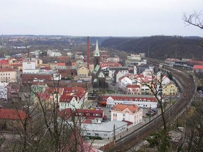
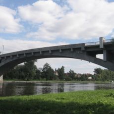
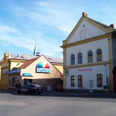
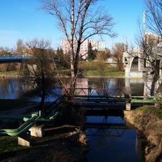
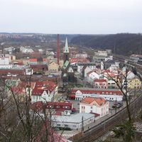
Kralupy nad Vltavou is a town in Central Bohemia situated along both banks of the Vltava River. The settlement includes a historic core with administrative buildings, residential areas, and local shops that serve the community.

The town was first documented in 1253 as a small settlement in the region. The construction of the Prague-Dresden railway in 1851 brought rapid growth and transformed it into an industrial center.

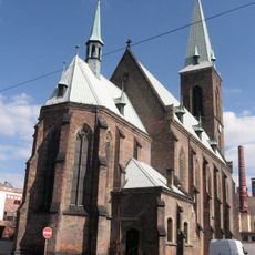
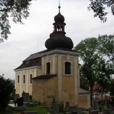
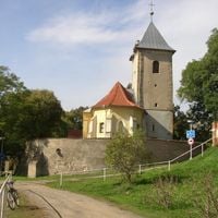
The Church of the Assumption and Saint Wenceslaus dominates the town center with its detailed stone carvings and pointed arches. Walking through the streets, you notice buildings from different periods that reflect how the town has grown and changed over time.

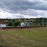
The railway station is the main transportation hub with regular connections to Prague and surrounding towns. The town center is easily accessible on foot from the station, making it simple to explore different areas.

A large petrochemical complex has operated in the town for decades and remains a major employer. This industrial facility is among the largest of its kind in the country.

The community of curious travelers

AroundUs brings together thousands of curated places, local tips, and hidden gems, enriched daily by 60,000 contributors worldwide.

Start exploring
Elevation above the sea
179 m
Reference
CZ0206534951
Shares border with
Dolany nad Vltavou, Olovnice, Nelahozeves, Veltrusy, Otvovice, Velvary, Holubice, Chvatěruby
GPS coordinates
50.24115,14.31157
Latest update
December 22, 2025 14:30
Around this place
Nelahozeves Chateau
Czech Republic

Nelahozeves Chateau

2.3 km
Birth house of Antonín Dvořák
Czech Republic

Birth house of Antonín Dvořák

2.5 km
Cemetery chapel in Kralupy nad Vltavou
Czech Republic

Cemetery chapel in Kralupy nad Vltavou

947 m
Hostibejk
Czech Republic

Hostibejk

462 m
Sprašová rokle u Zeměch
Czech Republic

Sprašová rokle u Zeměch

3.6 km
Dvořákova stezka
Czech Republic

Dvořákova stezka

1.1 km
Church of the Assumption of the Virgin Mary and of Saint Wenceslaus
Czech Republic

Church of the Assumption of the Virgin Mary and of Saint Wenceslaus

94 m
Church of Saint James the Greater
Czech Republic

Church of Saint James the Greater

2 km
Most T. G. Masaryka
Czech Republic

Most T. G. Masaryka

385 m
Church of Saint Andrew in Nelahozeves
Czech Republic

Church of Saint Andrew in Nelahozeves

2.5 km
Czech Republic

Roudnice Lobkowicz Library

2.3 km
Synagogue in Kralupy nad Vltavou
Czech Republic

Synagogue in Kralupy nad Vltavou

276 m
Minice
Czech Republic

Minice

3.3 km
Otvovická skála
Czech Republic

Otvovická skála

3.7 km
Minická skála
Czech Republic

Minická skála

3 km
Church of the Nativity of Saint John the Baptist
Czech Republic

Church of the Nativity of Saint John the Baptist

3.3 km
Lobečská skála
Czech Republic

Lobečská skála

826 m
Dub u Zeměch
Czech Republic

Dub u Zeměch

4.4 km
Klenutý most přes Zákolanský potok před ústím
Czech Republic

Klenutý most přes Zákolanský potok před ústím

280 m
Most ulice 9. května přes Knovízský potok v Kralupech nad Vltavou
Czech Republic

Most ulice 9. května přes Knovízský potok v Kralupech nad Vltavou

3.3 km
Lávka přes ústí Zákolanského potoka
Czech Republic

Lávka přes ústí Zákolanského potoka

341 m
Czech Republic

Lávka přes Zákolanský potok proti podchodu pod Mostní ulicí

249 m
Pomník Georga Karse v Žižkově ulici v Kralupech nad Vltavou
Czech Republic

Pomník Georga Karse v Žižkově ulici v Kralupech nad Vltavou

87 m
Socha sv. Jana Nepomuckého, Kralupy nad Vltavou, ul. V Růžovém údolí
Czech Republic

Socha sv. Jana Nepomuckého, Kralupy nad Vltavou, ul. V Růžovém údolí

2.4 km
Central cross at the cemetery in Kralupy nad Vltavou
Czech Republic

Central cross at the cemetery in Kralupy nad Vltavou

1.1 km
Maria column in Mikovice
Czech Republic

Maria column in Mikovice

1.8 km
House No 5 in Minice
Czech Republic

House No 5 in Minice

2.1 km
Usedlost čp. 3
Czech Republic

Usedlost čp. 3

2.8 km
Show the full map
Reviews
Share your experience

No review yet

Discussions
Start a discussion...

No discussion yet

« Kralupy nad Vltavou - Municipal center in Central Bohemia Region, Czech Republic » is provided by Around Us (aroundus.com). Images and texts are derived from Wikimedia project under a Creative Commons license. You are allowed to copy, distribute, and modify copies of this page, under the conditions set by the license, as long as this note is clearly visible.

Discover hidden gems everywhere you go!

From secret cafés to breathtaking viewpoints, skip the crowded tourist spots and find places that match your style. Our app makes it easy with voice search, smart filtering, route optimization, and insider tips from travelers worldwide. Download now for the complete mobile experience.

Around Us App Screenshot

A unique approach to discovering new places

Le Figaro

All the places worth exploring

France Info

A tailor-made excursion in just a few clicks

20 Minutes

Around Us
Travel Guide & Maps
Download

Send to your phone

QR Code
1

Open the camera app on your mobile.

2

Point at the QR code with your camera. A notification will appear.

3

Tap the notification to open the link.