Cheshire Bridge

Log in to your account

AroundUs is a community-driven map of interesting places, built by curious explorers like you. It grows with every review, story, and photo you share.
Connect to save your favorite spots, contribute locations, and create personalized routes.
Continue with Google
Continue with Apple
Continue with X
Continue with Facebook
Continue with email
By continuing, you accept our Terms and Conditions and our Privacy Policy
Create an account
Add to collection
Map
Suggest a change
Share

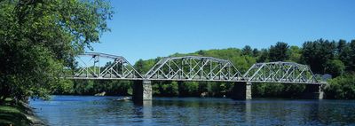
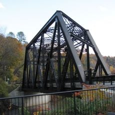
Cheshire Bridge, Railway and road bridge in Sullivan County and Windsor County, United States

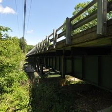
Cheshire Bridge is a road and railway crossing over the Connecticut River between Charlestown, New Hampshire, and Springfield, Vermont. The structure features three Pennsylvania truss spans and measures approximately 489 feet in length.

A wooden toll bridge stood at this location from 1806 before being replaced by the current steel structure built in 1930. The McClintic-Marshall Company constructed this new bridge to handle growing traffic between the two states for decades to come.

The bridge serves as a daily crossing point linking New Hampshire and Vermont residents, forming a tangible connection between two communities. For people on both sides, it represents a familiar threshold in their regular travel patterns.

The bridge is easily accessible from public roads on both sides of the Connecticut River and provides direct passage for vehicles. Access is straightforward from Charlestown on the New Hampshire side and from Springfield on the Vermont side.

The bridge was one of the few places in the region where trains and cars shared the same structure until railway operations stopped in 1984. This dual function made it a rare example of combined transportation infrastructure in New England during much of the 20th century.
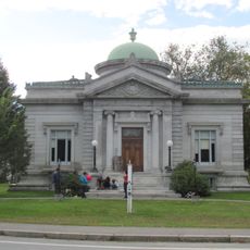
Location: Sullivan County

Location: Windsor County

Official opening: 1930

GPS coordinates: 43.26050,-72.42730

Latest update: December 13, 2025 11:42

Photos
Around this place
Fort at Number 4
United States of America

Fort at Number 4

730 m
Stellafane Observatory
United States of America

Stellafane Observatory

7.7 km
Bartonsville Covered Bridge
United States of America

Bartonsville Covered Bridge

9.8 km
Rockingham Meeting House
United States of America

Rockingham Meeting House

9.4 km
Hartness House
United States of America

Hartness House

6.1 km
Eureka Schoolhouse
United States of America

Eureka Schoolhouse

2.3 km
Worrall Covered Bridge
United States of America

Worrall Covered Bridge

10.3 km
Greenwood House
United States of America

Greenwood House

13 km
Cold River Bridge
United States of America

Cold River Bridge

12.1 km
Acworth Silsby Library
United States of America

Acworth Silsby Library

11.9 km
Prentiss Bridge
United States of America

Prentiss Bridge

12.3 km
United States of America

Park Street School

6.4 km
Parker Hill Rural Historic District
United States of America

Parker Hill Rural Historic District

5.9 km
Shedd-Porter Memorial Library
United States of America

Shedd-Porter Memorial Library

13.5 km
Charlestown Town Hall
United States of America

Charlestown Town Hall

3.4 km
Gould's Mill Bridge
United States of America

Gould's Mill Bridge

2.6 km
Rockingham Village Historic District
United States of America

Rockingham Village Historic District

9.5 km
Southview Housing Historic District
United States of America

Southview Housing Historic District

4.8 km
Charlestown Main Street Historic District
United States of America

Charlestown Main Street Historic District

2.7 km
Farwell School
United States of America

Farwell School

6.3 km
North Charlestown Historic District
United States of America

North Charlestown Historic District

6.4 km
Spencer Hollow School
United States of America

Spencer Hollow School

4.1 km
Gen. Lewis R. Morris House
United States of America

Gen. Lewis R. Morris House

3.5 km
Williams River Route 5 Bridge
United States of America

Williams River Route 5 Bridge

9.1 km
Lockwood-Boynton House
United States of America

Lockwood-Boynton House

11.4 km
Augustus and Laura Blaisdell House
United States of America

Augustus and Laura Blaisdell House

13.2 km
Springfield Downtown Historic District
United States of America

Springfield Downtown Historic District

6.5 km
Springfield Cinemas 3
United States of America

Springfield Cinemas 3

6.2 km
Show the full map
Reviews

Visited this place? Tap the stars to rate it and share your experience / photos with the community! Try now! You can cancel it anytime.

« Cheshire Bridge - Railway and road bridge in Sullivan County and Windsor County, United States » is provided by Around Us (aroundus.com). Images and texts are derived from Wikimedia project under a Creative Commons license. You are allowed to copy, distribute, and modify copies of this page, under the conditions set by the license, as long as this note is clearly visible.

Discover hidden gems everywhere you go!

From secret cafés to breathtaking viewpoints, skip the crowded tourist spots and find places that match your style. Our app makes it easy with voice search, smart filtering, route optimization, and insider tips from travelers worldwide. Download now for the complete mobile experience.

Around Us App Screenshot

A unique approach to discovering new places

Le Figaro

All the places worth exploring

France Info

A tailor-made excursion in just a few clicks

20 Minutes