Enable Location

We need your location to show you interesting places around you

Discover nearby places

Find interesting locations and hidden gems around you

Precise directions

Get accurate directions and distances to places

Your location is never shared with other users. It's only used when you tap the location button.

Bowling Ball Beach

Log in to your account

Start exploring — it's free

Trusted by 62,876 travelers worldwide

Continue with Google
Continue with Apple
or

We will send you a code to connect

By continuing, you accept our Terms and Conditions and our Privacy Policy

Check your inbox

We've sent a pincode in your inbox. Please enter the code below.

Bowling Ball Beach

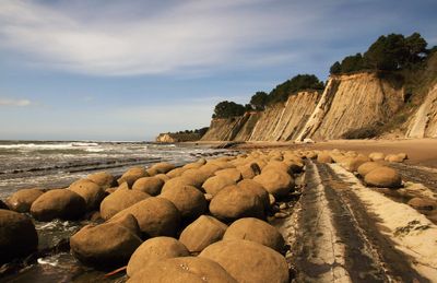
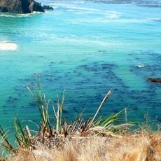
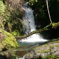
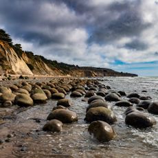
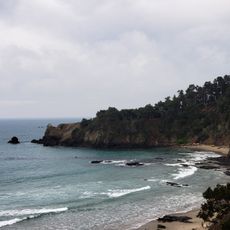
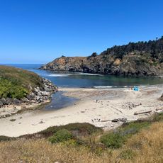
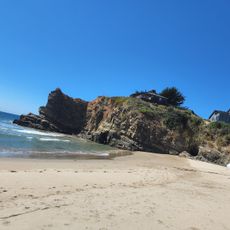
Bowling Ball Beach, Coastal beach with geological formations in Mendocino County, California.

Bowling Ball Beach is a coastal area in Mendocino County, California, where round sandstone blocks are scattered across the sand and shallow water. These spherical formations developed through natural erosion and create an unusual geological feature that sets this shoreline apart from typical California beaches.

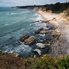
The spherical blocks formed over millions of years as ocean waves carved away softer rock layers around harder sandstone concretions. This natural erosion process continued over long periods and created the formations visible today.

Photographers and nature enthusiasts gather at this location to document the unusual geological structures during optimal lighting conditions.

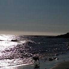
Visitors should plan their arrival according to tide tables and come during low tide to see the formations on the seafloor and in the sand. A visit in early morning or late afternoon hours offers the best light for taking photographs.

The spherical blocks did not form naturally in their rounded shape – each one was once embedded in the surrounding rock layer and was freed by millions of years of wave erosion. Many visitors mistakenly think the formations were intentionally placed, which makes this spot a popular mystery among nature observers.

The community of curious travelers

AroundUs brings together thousands of curated places, local tips, and hidden gems, enriched daily by 60,000 contributors worldwide.

Start exploring
Location
GPS coordinates
38.87074,-123.65835
Latest update
December 8, 2025 19:53
Around this place
Point Arena Light
United States of America

Point Arena Light

11.8 km
Salt Point State Park
United States of America

Salt Point State Park

43.9 km
Hendy Woods State Park
United States of America

Hendy Woods State Park

27.4 km
Navarro River Redwoods State Park
United States of America

Navarro River Redwoods State Park

33.9 km
Condominium 1
United States of America

Condominium 1

29.2 km
Manchester State Park
United States of America

Manchester State Park

13.5 km
Schooner Gulch State Beach
United States of America

Schooner Gulch State Beach

413 m
Greenwood State Beach
United States of America

Greenwood State Beach

29.4 km
Albion River Bridge
United States of America

Albion River Bridge

40.9 km
Gualala Point Regional Park
United States of America

Gualala Point Regional Park

17.1 km
Arena Cove Historic District
United States of America

Arena Cove Historic District

6.5 km
Galbreath Wildlands Preserve
United States of America

Galbreath Wildlands Preserve

34.2 km
Fensalden Inn
United States of America

Fensalden Inn

38.2 km
Baker House
United States of America

Baker House

28.7 km
St. Paul's Methodist Episcopal Church
United States of America

St. Paul's Methodist Episcopal Church

5.6 km
Main Street Historic Commercial District
United States of America

Main Street Historic Commercial District

5.2 km
Con Creek School
United States of America

Con Creek School

29.5 km
United States of America

Manchester Schoolhouse

11 km
Bowling Ball Beach
United States of America

Bowling Ball Beach

0 m
Pebble Beach
United States of America

Pebble Beach

27.1 km
Ohlson Beach
United States of America

Ohlson Beach

24.9 km
Hoyt–Scott House
United States of America

Hoyt–Scott House

5.3 km
Fish Rock Beach
United States of America

Fish Rock Beach

10 km
Stump Beach
United States of America

Stump Beach

42.7 km
Cooks Beach
United States of America

Cooks Beach

12.3 km
Schooner Gulch State Beach
United States of America

Schooner Gulch State Beach

407 m
Iverson House
United States of America

Iverson House

5.1 km
Billy Ketchum House
United States of America

Billy Ketchum House

5.4 km
Show the full map
« Bowling Ball Beach - Coastal beach with geological formations in Mendocino County, California » is provided by Around Us (aroundus.com). Images and texts are derived from Wikimedia project under a Creative Commons license. You are allowed to copy, distribute, and modify copies of this page, under the conditions set by the license, as long as this note is clearly visible.

Discover hidden gems everywhere you go!

From secret cafés to breathtaking viewpoints, skip the crowded tourist spots and find places that match your style. Our app makes it easy with voice search, smart filtering, route optimization, and insider tips from travelers worldwide. Download now for the complete mobile experience.

Around Us App Screenshot

A unique approach to discovering new places

Le Figaro

All the places worth exploring

France Info

A tailor-made excursion in just a few clicks

20 Minutes

Around Us
Travel Guide & Maps
Download

Send to your phone

QR Code
1

Open the camera app on your mobile.

2

Point at the QR code with your camera. A notification will appear.

3

Tap the notification to open the link.