Durazno Plantation

Log in to your account

AroundUs is a community-driven map of interesting places, built by curious explorers like you. It grows with every review, story, and photo you share.
Connect to save your favorite spots, contribute locations, and create personalized routes.
By continuing, you accept our Terms and Conditions and our Privacy Policy
Add to collection
Map
Suggest a change
Share

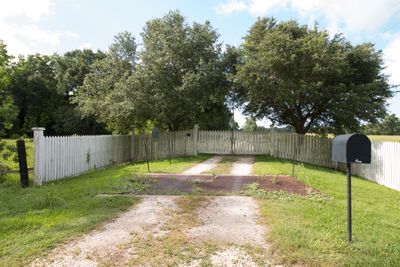
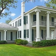
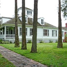
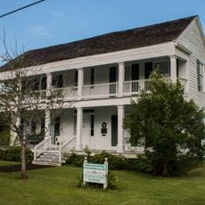
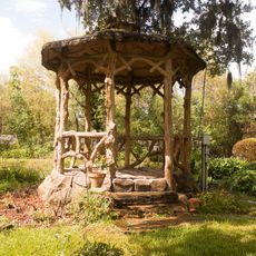
Durazno Plantation, Historic plantation in Jones Creek, Brazoria County, US
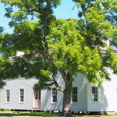
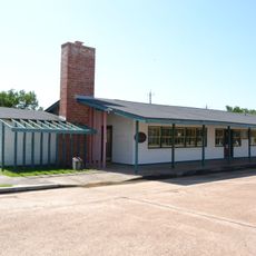
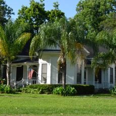
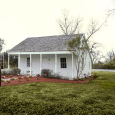
The Durazno Plantation spans 129 acres of land near Jones Creek, featuring period structures that reflect early Texas agricultural development.

William Joel Bryan established the plantation in 1840 after receiving it as a dowry upon his marriage to Lavinia Perry, using land from Peach Point Plantation.

The plantation's name translates to 'peach' in Spanish, reflecting the multicultural influences during Texas's transition from Mexican territory to American statehood.

Located at coordinates 28.9561, -95.4492, the plantation maintains its original boundaries and offers insights into 19th-century agricultural practices.

The Texas Historical Commission maintains detailed photographic records of Durazno Plantation, including black and white images measuring 4 x 5 inches.

Location: Brazoria County

Address: S of Jones Creek off TX 36

GPS coordinates: 28.95610,-95.44920

Latest update: March 6, 2025 03:10

Around this place
Show the full map
Moody Gardens
United States of America

Moody Gardens

68.1 km
Brazos Bend State Park
United States of America

Brazos Bend State Park

49.2 km
Lone Star Flight Museum
United States of America

Lone Star Flight Museum

67.7 km
Clemens Unit
United States of America

Clemens Unit

7.7 km
Fort Crockett
United States of America

Fort Crockett

70.7 km
Galveston Causeway
United States of America

Galveston Causeway

66.5 km
Galveston Island State Park
United States of America

Galveston Island State Park

54.8 km
Varner–Hogg Plantation State Historical Site
United States of America

Varner–Hogg Plantation State Historical Site

29.6 km
Great Texas Coastal Birding Trail
United States of America

Great Texas Coastal Birding Trail

53.9 km
Levi Jordan Plantation
United States of America

Levi Jordan Plantation

19.8 km
Michel B. Menard House
United States of America

Michel B. Menard House

73.2 km
Congregation B'nai Israel
United States of America

Congregation B'nai Israel

73.5 km
San Bernard National Wildlife Refuge
United States of America

San Bernard National Wildlife Refuge

12.9 km
Saints Constantine and Helen Serbian Orthodox Church
United States of America

Saints Constantine and Helen Serbian Orthodox Church

72.3 km
Samuel May Williams House
United States of America

Samuel May Williams House

72.8 km
Hopper Field
United States of America

Hopper Field

7.3 km
Matagorda Beach
United States of America

Matagorda Beach

65.2 km
Grace Episcopal Church
United States of America

Grace Episcopal Church

73 km
Alden B. Dow Office and Lake Jackson City Hall
United States of America

Alden B. Dow Office and Lake Jackson City Hall

9.5 km
Robinson Stadium
United States of America

Robinson Stadium

70.2 km
Hensley-Gusman House
United States of America

Hensley-Gusman House

50.3 km
The Settlement Historic District
United States of America

The Settlement Historic District

66 km
Ammon Underwood House
United States of America

Ammon Underwood House

26.2 km
Matagorda County Monument
United States of America

Matagorda County Monument

50.8 km
Lake Jackson Freeport Beach
United States of America

Lake Jackson Freeport Beach

7.8 km
Cedar Lawn Historic District
United States of America

Cedar Lawn Historic District

71.8 km
Gazebo for James Richard Marmion
United States of America

Gazebo for James Richard Marmion

21.2 km
Bay City USO Building
United States of America

Bay City USO Building

49.9 km
Show the full map

Reviews

Visited this place? Tap the stars to rate it and share your experience / photos with the community! Try now! You can cancel it anytime.

« Durazno Plantation - Historic plantation in Jones Creek, Brazoria County, US » is provided by Around Us (aroundus.com). Images and texts are derived from Wikimedia project under a Creative Commons license. You are allowed to copy, distribute, and modify copies of this page, under the conditions set by the license, as long as this note is clearly visible.

Discover hidden gems everywhere you go!

From secret cafés to breathtaking viewpoints, skip the crowded tourist spots and find places that match your style. Our app makes it easy with voice search, smart filtering, route optimization, and insider tips from travelers worldwide. Download now for the complete mobile experience.

Around Us App Screenshot

A unique approach to discovering new places

Le Figaro

All the places worth exploring

France Info

A tailor-made excursion in just a few clicks

20 Minutes