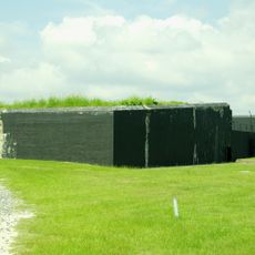
Enable Location

We need your location to show you interesting places around you

Discover nearby places

Find interesting locations and hidden gems around you

Precise directions

Get accurate directions and distances to places

Your location is never shared with other users. It's only used when you tap the location button.

Log in to your account

Start exploring — it's free

Trusted by 63,781 travelers worldwide

Continue with Google
Continue with Apple
or

We will send you a code to connect

By continuing, you accept our Terms and Conditions and our Privacy Policy

Check your inbox

We've sent a pincode in your inbox. Please enter the code below.

Discussion Reviews Photo
1.1k Popularity

Fort Palmetto

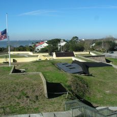
Fort Palmetto is a coastal earthwork fort in Charleston County built to protect against attacks from the sea. The structure has three gun batteries and measures about 160 feet long and 80 feet deep, with 15-foot-high walls and a powder magazine at 25 feet elevation.

The fort was built in late 1861 and was part of a defense line planned by General Robert E. Lee. It served during the war under soldiers from the 20th South Carolina Volunteer Infantry and was one of the few installations with full armament.

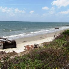
The name Palmetto comes from the palm trees that grow naturally in this region and shape the landscape. The earthwork structure still shows the simple, functional design that soldiers needed for their defensive duties.

The fort sits along a walking trail about a mile and a half long that is flat and easy to navigate. The path passes by freshwater ponds and marshland and ends at an elevated viewing platform overlooking Dewees Inlet.

The fort was one of the few installations along the defense line that had full armament, while most others remained unequipped. It was armed with one large nine-inch gun and two rifled cannons, representing rare firepower in this coastal section.

The community of curious travelers

AroundUs brings together thousands of curated places, local tips, and hidden gems, enriched daily by 60,000 contributors worldwide.

Start exploring
GPS coordinates
32.82310,-79.76560
Latest update
February 9, 2026 07:42
Around this place
Fort Moultrie
United States of America

Fort Moultrie

11.1 km
Fort Sumter and Fort Moultrie National Historical Park
United States of America

Fort Sumter and Fort Moultrie National Historical Park

11.5 km
Ben Sawyer Bridge
United States of America

Ben Sawyer Bridge

9.1 km
Boone Hall Plantation
United States of America

Boone Hall Plantation

6.6 km
Charleston Light
United States of America

Charleston Light

10.3 km
Oakland Plantation House
United States of America

Oakland Plantation House

4.6 km
Mount Pleasant Historic District
United States of America

Mount Pleasant Historic District

11.1 km
Christ Church
United States of America

Christ Church

5.1 km
Battery Thomson
United States of America

Battery Thomson

10 km
Battery Gadsden
United States of America

Battery Gadsden

9.9 km
U.S. Coast Guard Historic District
United States of America

U.S. Coast Guard Historic District

10.3 km
Old Berkeley County Courthouse
United States of America

Old Berkeley County Courthouse

10.1 km
Battery Jasper
United States of America

Battery Jasper

11 km
Moultrieville Historic District
United States of America

Moultrieville Historic District

11.2 km
Sullivan's Island Range Lights
United States of America

Sullivan's Island Range Lights

11 km
Charleston Fun Park
United States of America

Charleston Fun Park

5.2 km
Dr. John B. Patrick House
United States of America

Dr. John B. Patrick House

10.1 km
Sullivan's Island Historic District
United States of America

Sullivan's Island Historic District

10.3 km
Snee Farm House
United States of America

Snee Farm House

6.1 km
Splash Island Water Park
United States of America

Splash Island Water Park

8 km
Osceola's tomb
United States of America

Osceola's tomb

11.1 km
Fort Moultrie Visitor Center
United States of America

Fort Moultrie Visitor Center

11.1 km
Smokehouse
United States of America

Smokehouse

6.7 km
Fort Moultrie Quartermaster and Support Facilities Historic District
United States of America

Fort Moultrie Quartermaster and Support Facilities Historic District

10.8 km
Stella Maris Catholic Church
United States of America

Stella Maris Catholic Church

11.1 km
Patapsco Monument
United States of America

Patapsco Monument

11.1 km
1809 Powder Magazine
United States of America

1809 Powder Magazine

11.2 km
Sullivan's Island Beach
United States of America

Sullivan's Island Beach

10.3 km
Show the full map
Reviews
Share your experience

No review yet

Discussions
Start a discussion...

No discussion yet

« Fort Palmetto » is provided by Around Us (aroundus.com). Images and texts are derived from Wikimedia project under a Creative Commons license. You are allowed to copy, distribute, and modify copies of this page, under the conditions set by the license, as long as this note is clearly visible.

Discover hidden gems everywhere you go!

From secret cafés to breathtaking viewpoints, skip the crowded tourist spots and find places that match your style. Our app makes it easy with voice search, smart filtering, route optimization, and insider tips from travelers worldwide. Download now for the complete mobile experience.

Around Us App Screenshot

A unique approach to discovering new places

Le Figaro

All the places worth exploring

France Info

A tailor-made excursion in just a few clicks

20 Minutes

Around Us
Travel Guide & Maps
Download

Send to your phone

QR Code
1

Open the camera app on your mobile.

2

Point at the QR code with your camera. A notification will appear.

3

Tap the notification to open the link.