Enable Location

We need your location to show you interesting places around you

Discover nearby places

Find interesting locations and hidden gems around you

Precise directions

Get accurate directions and distances to places

Your location is never shared with other users. It's only used when you tap the location button.

Mount Pleasant Historic District

Log in to your account

Start exploring — it's free

Trusted by 61,749 travelers worldwide

Continue with Google
Continue with Apple
or

We will send you a code to connect

By continuing, you accept our Terms and Conditions and our Privacy Policy

Check your inbox

We've sent a pincode in your inbox. Please enter the code below.

Mount Pleasant Historic District, Historic district in Mount Pleasant, South Carolina, US.

Description

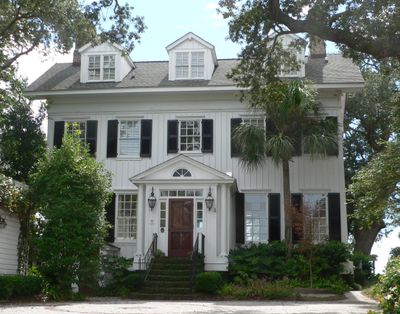
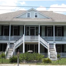
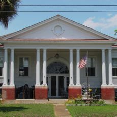
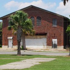
Mount Pleasant Historic District is a neighborhood with buildings from the colonial era through the early 1900s, showing Federal, Georgian, and Victorian styles side by side. Walking through, you see how the town developed over time, with older homes next to later additions.

History

The district was settled during colonial times and grew into a key residential area of Mount Pleasant. It gained National Register recognition because its buildings show how the town changed and developed over centuries.

Culture

The district connects to the Gullah/Geechee Cultural Heritage Corridor, reflecting the long history of African American communities in South Carolina. You can sense this heritage through the buildings and how people still use the spaces today.

Practical

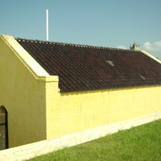
You can walk through the district at your own pace, with informational plaques on buildings explaining the history of specific structures and sites. The area is easy to navigate and works well for a leisurely stroll to take in the different buildings.

Did you know?

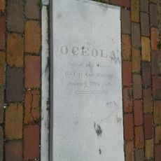
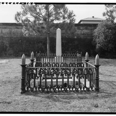
The Scanlonville Cemetery within the district holds burial sites of important figures who shaped Mount Pleasant across different eras. It is a quiet place that preserves the stories of people who influenced how the town developed.

Location
GPS coordinates
32.78610,-79.87580
Latest update
December 14, 2025 12:25

AroundUs brings together thousands of curated places, local tips, and hidden gems, enriched daily by 60,000 contributors worldwide. Discover all places nearby (Mount Pleasant).

Around this place
Fort Sumter
United States of America

Fort Sumter

3.7 km
USS Yorktown
United States of America

USS Yorktown

3.1 km
USS Laffey
United States of America

USS Laffey

3 km
Arthur Ravenel Jr. Bridge
United States of America

Arthur Ravenel Jr. Bridge

4.1 km
Fort Moultrie
United States of America

Fort Moultrie

3.3 km
Patriots Point
United States of America

Patriots Point

2.8 km
Castle Pinckney
United States of America

Castle Pinckney

3.6 km
Fort Sumter and Fort Moultrie National Historical Park
United States of America

Fort Sumter and Fort Moultrie National Historical Park

3.6 km
Ben Sawyer Bridge
United States of America

Ben Sawyer Bridge

3.5 km
Charleston Light
United States of America

Charleston Light

4.4 km
Fort Johnson
United States of America

Fort Johnson

4.3 km
Battery Thomson
United States of America

Battery Thomson

4.4 km
Fort Sumter Range Lights
United States of America

Fort Sumter Range Lights

3.8 km
Old Berkeley County Courthouse
United States of America

Old Berkeley County Courthouse

1.1 km
Battery Jasper
United States of America

Battery Jasper

3.6 km
Moultrieville Historic District
United States of America

Moultrieville Historic District

3.2 km
Sullivan's Island Range Lights
United States of America

Sullivan's Island Range Lights

4 km
Dr. John B. Patrick House
United States of America

Dr. John B. Patrick House

4.2 km
Sullivan's Island Historic District
United States of America

Sullivan's Island Historic District

4.1 km
Osceola's tomb
United States of America

Osceola's tomb

3.4 km
Battery Huger
United States of America

Battery Huger

3.8 km
Fort Moultrie Visitor Center
United States of America

Fort Moultrie Visitor Center

3.3 km
Flagpole Monument
United States of America

Flagpole Monument

3.8 km
Garrison Monument
United States of America

Garrison Monument

3.8 km
Stella Maris Catholic Church
United States of America

Stella Maris Catholic Church

3.3 km
Fort Moultrie Quartermaster and Support Facilities Historic District
United States of America

Fort Moultrie Quartermaster and Support Facilities Historic District

3.7 km
1809 Powder Magazine
United States of America

1809 Powder Magazine

3.4 km
Patapsco Monument
United States of America

Patapsco Monument

3.4 km
Show the full map
« Mount Pleasant Historic District - Historic district in Mount Pleasant, South Carolina, US » is provided by Around Us (aroundus.com). Images and texts are derived from Wikimedia project under a Creative Commons license. You are allowed to copy, distribute, and modify copies of this page, under the conditions set by the license, as long as this note is clearly visible.

Discover hidden gems everywhere you go!

From secret cafés to breathtaking viewpoints, skip the crowded tourist spots and find places that match your style. Our app makes it easy with voice search, smart filtering, route optimization, and insider tips from travelers worldwide. Download now for the complete mobile experience.

Around Us App Screenshot

A unique approach to discovering new places

Le Figaro

All the places worth exploring

France Info

A tailor-made excursion in just a few clicks

20 Minutes

Around Us
Travel Guide & Maps
Download

Send to your phone

QR Code
1

Open the camera app on your mobile.

2

Point at the QR code with your camera. A notification will appear.

3

Tap the notification to open the link.