Chest opened
+${chestReward.xp} XP
Explorer
NOUVEAU ×${chestReward.collectible.quantity}
tapez pour fermer
Chest locked

Open chests in the app

Around Us is built for your phone — chests unlock when you walk, explore and capture nearby places.

Enable Location

We need your location to show you interesting places around you

Discover nearby places

Find interesting locations and hidden gems around you

Precise directions

Get accurate directions and distances to places

Your location is never shared with other users. It's only used when you tap the location button.

Log in to your account

Start exploring — it's free

Trusted by 72,889 travelers worldwide

Continue with Google
Continue with Apple
or

We will send you a code to connect

By continuing, you accept our Terms and Conditions and our Privacy Policy

Check your inbox

We've sent a pincode in your inbox. Please enter the code below.

Redonda Formation
Discussion Reviews Photo
1.9k Popularity

Redonda Formation, Geological formation in northern New Mexico, US

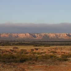
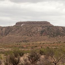
Redonda Formation is a rock unit in northern New Mexico made up of layers of red-brown sandstone and mudstone. These deposits formed during the Late Triassic and today spread across several counties, creating the exposed red-toned hills visible throughout the region.

Scientists first classified this rock unit as part of the Chinle Formation in 1947, then elevated it to its own formation status in 1959. That change in classification helped geologists better understand the Triassic rock sequences across the region.

The name comes from the Spanish word for round, referring to the landscape's shape in this area. Visitors today see reddish-toned hills and exposed rock faces that define the appearance of this high desert region.

The rock exposures spread across multiple counties and are best accessed via local roads and walking routes. Visitors should prepare for hot, dry conditions and bring plenty of water and sun protection when exploring the area.

The rocks preserve traces of an ancient lake system with many invertebrate fossils like seed shrimp and clam shrimp. These tiny fossils reveal clues about life in this prehistoric water body hundreds of millions of years ago.

The community of curious travelers

AroundUs brings together thousands of curated places, local tips, and hidden gems, enriched daily by 60,000 contributors worldwide.

Start exploring
GPS coordinates
34.96500,-103.70100
Latest update
March 18, 2026 09:39
Around this place
Caprock Escarpment
United States of America

Caprock Escarpment

34.1 km
Blue Swallow Motel
United States of America

Blue Swallow Motel

23.1 km
Tucumcari Mountain
United States of America

Tucumcari Mountain

18.8 km
United States of America

Ute Lake State Park

46 km
United States of America

Fort Bascom

39.3 km
Cactus Motor Lodge
United States of America

Cactus Motor Lodge

22.9 km
Richardson Store
United States of America

Richardson Store

36.2 km
Metropolitan Park Bathhouse and Pool Historic District
United States of America

Metropolitan Park Bathhouse and Pool Historic District

22.1 km
Odeon Theatre
United States of America

Odeon Theatre

24.1 km
Baca-Goodman House
United States of America

Baca-Goodman House

23.8 km
Arch Hurley Conservancy District Office Building
United States of America

Arch Hurley Conservancy District Office Building

23.6 km
Tucumcari Railroad Museum
United States of America

Tucumcari Railroad Museum

24.1 km
United States of America

The Caprock

19 km
United States of America

12 Shores

45.1 km
United States of America

Tee Pee Curios

23 km
United States of America

Baca-Goodman House Historic Site

23.1 km
United States of America

Quay County Courthouse Historic Site

23.1 km
United States of America

Rock Island-Southern Pacific Passenger Depot Historic Site

23.1 km
United States of America

Tucumcari Trading Post

23.2 km
United States of America

Tee pee curios (Tumtucari)

23 km
United States of America

Tucumcari Municipal Golf Course

23.2 km
United States of America

Tucumcari Trading Post

23.2 km
United States of America

ART City

30.6 km
United States of America

Caprock Amphitheatre

31.9 km
United States of America

The Legendary Road

23.2 km
United States of America

The Minds Eye

30.8 km
United States of America

San Jon Hill View

31.6 km
United States of America

Caprock View

31.4 km
Show the full map
Reviews
Share your experience

No review yet

Discussions
Start a discussion...

No discussion yet

« Redonda Formation - Geological formation in northern New Mexico, US » is provided by Around Us (aroundus.com). Images and texts are derived from Wikimedia project under a Creative Commons license. You are allowed to copy, distribute, and modify copies of this page, under the conditions set by the license, as long as this note is clearly visible.

Discover hidden gems everywhere you go!

From secret cafés to breathtaking viewpoints, skip the crowded tourist spots and find places that match your style. Our app makes it easy with voice search, smart filtering, route optimization, and insider tips from travelers worldwide. Download now for the complete mobile experience.

Around Us App Screenshot

A unique approach to discovering new places

Le Figaro

All the places worth exploring

France Info

A tailor-made excursion in just a few clicks

20 Minutes

Around Us
Travel Guide & Maps
Download

Send to your phone

QR Code
1

Open the camera app on your mobile.

2

Point at the QR code with your camera. A notification will appear.

3

Tap the notification to open the link.