Enable Location

We need your location to show you interesting places around you

Discover nearby places

Find interesting locations and hidden gems around you

Precise directions

Get accurate directions and distances to places

Your location is never shared with other users. It's only used when you tap the location button.

Caprock Escarpment

Log in to your account

Start exploring — it's free

Trusted by 62,056 travelers worldwide

Continue with Google
Continue with Apple
or

We will send you a code to connect

By continuing, you accept our Terms and Conditions and our Privacy Policy

Check your inbox

We've sent a pincode in your inbox. Please enter the code below.

Caprock Escarpment

Caprock Escarpment, Geological formation in Texas and New Mexico, United States.

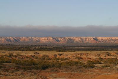
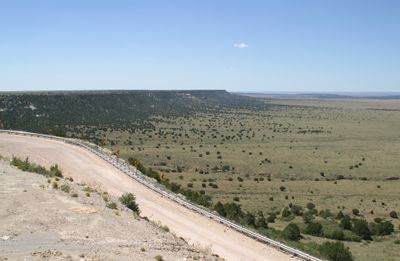
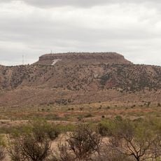
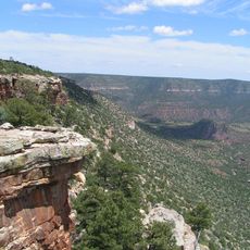
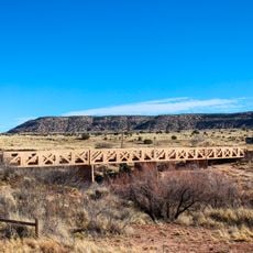
The Caprock Escarpment is a geological formation along the eastern edge of the Llano Estacado plateau, where limestone cliffs rise steeply above the surrounding terrain. The formation stretches across hundreds of kilometers and creates a dramatic boundary between the elevated plateau and the flat plains below.

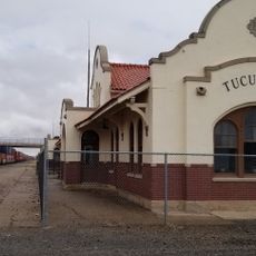
Indigenous peoples inhabited the region for thousands of years, using the natural caves and crevices of the cliffs for shelter and protection. These early inhabitants left behind archaeological evidence that documents their presence across long periods.

The escarpment shaped how local herders managed their livestock, using natural barriers to guide and protect their animals across the plains.

The formation can be viewed from several vantage points scattered across the region, with easy access from main roads. Early morning or late afternoon visits offer the best light for observing the rock formations and surrounding landscape.

Tunnels along the formation house massive bat colonies that gather during summer months. At dusk, thousands of bats emerge in coordinated waves, creating a remarkable natural display.

The community of curious travelers

AroundUs brings together thousands of curated places, local tips, and hidden gems, enriched daily by 60,000 contributors worldwide.

Start exploring
Location
GPS coordinates
34.90970,-104.06900
Latest update
December 20, 2025 15:59
Around this place
Fort Sumner
United States of America

Fort Sumner

57.7 km
Trementina Base
United States of America

Trementina Base

82.3 km
Blue Swallow Motel
United States of America

Blue Swallow Motel

43.4 km
Tucumcari Mountain
United States of America

Tucumcari Mountain

42 km
Conchas Lake
United States of America

Conchas Lake

54.4 km
Sabinoso Wilderness
United States of America

Sabinoso Wilderness

92.1 km
Santa Rosa Lake State Park
United States of America

Santa Rosa Lake State Park

56.7 km
Conchas Dam
United States of America

Conchas Dam

56 km
Cactus Motor Lodge
United States of America

Cactus Motor Lodge

43.7 km
Richardson Store
United States of America

Richardson Store

20.7 km
Metropolitan Park Bathhouse and Pool Historic District
United States of America

Metropolitan Park Bathhouse and Pool Historic District

35.9 km
Odeon Theatre
United States of America

Odeon Theatre

43.3 km
Baca-Goodman House
United States of America

Baca-Goodman House

43.1 km
De Baca County Courthouse
United States of America

De Baca County Courthouse

51.2 km
Curry County Courthouse
United States of America

Curry County Courthouse

97 km
Arch Hurley Conservancy District Office Building
United States of America

Arch Hurley Conservancy District Office Building

43.1 km
Fort Sumner Railroad Bridge
United States of America

Fort Sumner Railroad Bridge

50.4 km
Guadalupe County Courthouse in Santa Rosa
United States of America

Guadalupe County Courthouse in Santa Rosa

56.5 km
Alexander Grzelachowski House and Store
United States of America

Alexander Grzelachowski House and Store

51.4 km
J. Julian Moise House
United States of America

J. Julian Moise House

56.2 km
Jesus M. Casaus House
United States of America

Jesus M. Casaus House

55.9 km
Park Lake Historic District
United States of America

Park Lake Historic District

55.7 km
Fort Sumner Cemetery Wall and Entry
United States of America

Fort Sumner Cemetery Wall and Entry

50.3 km
Fort Sumner Community House
United States of America

Fort Sumner Community House

50.6 km
Tucumcari Railroad Museum
United States of America

Tucumcari Railroad Museum

43.4 km
Princess Theatre
United States of America

Princess Theatre

43.8 km
Billy The Kid Museum
United States of America

Billy The Kid Museum

51.5 km
Variadero Bridge
United States of America

Variadero Bridge

64.2 km
Show the full map
« Caprock Escarpment - Geological formation in Texas and New Mexico, United States » is provided by Around Us (aroundus.com). Images and texts are derived from Wikimedia project under a Creative Commons license. You are allowed to copy, distribute, and modify copies of this page, under the conditions set by the license, as long as this note is clearly visible.

Discover hidden gems everywhere you go!

From secret cafés to breathtaking viewpoints, skip the crowded tourist spots and find places that match your style. Our app makes it easy with voice search, smart filtering, route optimization, and insider tips from travelers worldwide. Download now for the complete mobile experience.

Around Us App Screenshot

A unique approach to discovering new places

Le Figaro

All the places worth exploring

France Info

A tailor-made excursion in just a few clicks

20 Minutes

Around Us
Travel Guide & Maps
Download

Send to your phone

QR Code
1

Open the camera app on your mobile.

2

Point at the QR code with your camera. A notification will appear.

3

Tap the notification to open the link.